
FCCInfo.com
A Service of Cavell, Mertz & Associates, Inc.
(855) FCC-INFO
|
|
W247BM from 08/02/2004 |
|
|
||||||||||||||||
|
|
W247BM Channel: 247D 97.3 MHz Cooperstown, New York Service: FX - A translator or application for a translator. Facility ID: 140147 Fac. Service: FX Programming Delivery Method: Unspecified Status: License Application Accepted: 01/08/2010 Application Granted: 01/22/2010 File Number: BLFT-20100108ABX License Expires: 00/00/0000 Prefix Type: This is a license for a translator Application Type: License To Cover FCC Website Links: LMS Facility Details This Application CDBS Application Other W247BM Applications Other W247BM Applications in CDBS Including Superseded Applications Mailing Address Correspondence for W247BM Correspondence related to application BLFT-20100108ABX Service Contour - Open Street Map or USGS Map (60 dBu) Service Contour - KML / Google Earth (60 dBu) Class: D, A Noncommercial educational operating with no more than 10W Site Location: 42-40-44.3 N 74-53-57.6 W (NAD 83) Site Location: 42-40-44.0 N 74-53-59.0 W (Converted to NAD 27) Effective Radiated Power: 0 kW Horiz. ; 0.01 kW Vert. Transmitter Output Power: 0.013 kW Antenna Center HAAT: 0 m Horiz.; 147.9 m Vert. Antenna Center AMSL: 0 m Horiz.; 631 m Vert. Antenna Center HAG: 0 m Horiz.; 46 m Vert. Site Elevation: 585 m. (1919 ft.) Height Overall*: 59 m (194 ft.) (* As Filed In This Application, may differ from ASR Data, Below.) Directional Antenna Antenna Make/Model: None Antenna ID: 61047 Polarization:
| ||||||||||||||||||
| Antenna Data for Antenna Id: 61047 W247BM FX File: BLFT-20100108ABX None - Service: FX Pattern and Field Values Include a 320° Clockwise Rotation | 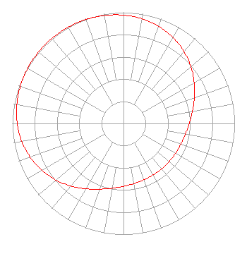 | ||||||||||||||||||
| Azimuth | Ratio | Azimuth | Ratio | Azimuth | Ratio | Azimuth | Ratio | ||||||||||||
| 0 | 0.975 | 10 | 0.956 | 20 | 0.929 | 30 | 0.892 | ||||||||||||
| 40 | 0.845 | 50 | 0.792 | 60 | 0.735 | 70 | 0.679 | ||||||||||||
| 80 | 0.630 | 90 | 0.592 | 100 | 0.566 | 110 | 0.549 | ||||||||||||
| 120 | 0.540 | 130 | 0.535 | 140 | 0.534 | 150 | 0.535 | ||||||||||||
| 160 | 0.540 | 170 | 0.549 | 180 | 0.566 | 190 | 0.592 | ||||||||||||
| 200 | 0.630 | 210 | 0.679 | 220 | 0.735 | 230 | 0.792 | ||||||||||||
| 240 | 0.845 | 250 | 0.892 | 260 | 0.929 | 270 | 0.956 | ||||||||||||
| 280 | 0.975 | 290 | 0.987 | 300 | 0.995 | 310 | 0.999 | ||||||||||||
| 320 | 1.000 | 330 | 0.999 | 340 | 0.995 | 350 | 0.987 | ||||||||||||
Structure Registration Number 1063193 Structure Type: TOWER Registered To: OTSEGO, COUNTY OF Structure Address: 2 Mi Se On Cornish Hill Cooperstown, NY County Name: Otsego County ASR Issued: 09/19/2012 Date Built: 01/01/1998 Site Elevation: 585.2 m (1920 ft.) Structure Height: 57.9 m (190 ft.) Height Overall: 59.1 m (194 ft.) Overall Height AMSL: 644.3 m (2114 ft.) Paint & Light FAA Chapters: None 42-40-44.0 N 74-53-58.0 W (NAD 83) 42-40-43.7 N 74-53-59.4 W (Converted to NAD 27) |
318 Central Avenue Albany, NY 12206 Phone: 518-465-5233 Not-for-Profit | Date: 01/08/2010 Application Certifier WAMC 318 Central Avenue Albany, NY 12206 Applicant CHARLES WILLIAMSON Digital Radio Engineering, Inc 2927 Us Route 6 Slate Hill, NY 10973 TECHNICAL CONSULTANT MARGARET L. MILLER Dow Lohnes Pllc 1200 New Hampshire Ave. Suite 800 Washington, DC 20036 | |||||||||||||||||