
FCCInfo.com
A Service of Cavell, Mertz & Associates, Inc.
(855) FCC-INFO
|
|
|
|
|
||||||||||||||||
|
|
W215BC Channel: 215D 90.9 MHz Steubenville, Ohio Service: FX - A translator or application for a translator. Facility ID: 91071 Fac. Service: FX Programming Delivery Method: Unspecified Status: License Application Accepted: 06/08/2000 Application Granted: 08/14/2000 File Number: BLFT-20000515ADD License Expires: 00/00/0000 Prefix Type: This is a license for a translator Application Type: License To Cover FCC Website Links: LMS Facility Details This Application CDBS Application Other W215BC Applications Other W215BC Applications in CDBS Including Superseded Applications Mailing Address Correspondence for W215BC Correspondence related to application BLFT-20000515ADD Service Contour - Open Street Map or USGS Map (60 dBu) Service Contour - KML / Google Earth (60 dBu) Class: D, A Noncommercial educational operating with no more than 10W Site Location: 40-21-06.2 N 80-39-22.3 W (NAD 83) Site Location: 40-21-06.0 N 80-39-23.0 W (Converted to NAD 27) Effective Radiated Power: 0 kW Horiz. ; 0.01 kW Vert. Transmitter Output Power: 0.004 kW Antenna Center HAAT: 0 m Horiz.; 159 m Vert. Antenna Center AMSL: 0 m Horiz.; 469 m Vert. Antenna Center HAG: 0 m Horiz.; 85 m Vert. Calculated Site Elevation: m. Height Overall*: 91 m (299 ft.) (* As Filed In This Application, may differ from ASR Data, Below.) Directional Antenna Antenna Make/Model: None Antenna ID: 16151 Polarization:
| ||||||||||||||||||
| Antenna Data for Antenna Id: 16151 W215BC FX File: BLFT-20000515ADD None - Service: FX | 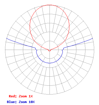 | ||||||||||||||||||
| Azimuth | Ratio | Azimuth | Ratio | Azimuth | Ratio | Azimuth | Ratio | ||||||||||||
| 0 | 1.000 | 10 | 0.980 | 20 | 0.916 | 30 | 0.817 | ||||||||||||
| 40 | 0.690 | 50 | 0.544 | 60 | 0.390 | 70 | 0.190 | ||||||||||||
| 80 | 0.050 | 90 | 0.030 | 100 | 0.030 | 110 | 0.030 | ||||||||||||
| 120 | 0.030 | 130 | 0.030 | 140 | 0.030 | 150 | 0.030 | ||||||||||||
| 160 | 0.030 | 170 | 0.030 | 180 | 0.030 | 190 | 0.030 | ||||||||||||
| 200 | 0.030 | 210 | 0.030 | 220 | 0.030 | 230 | 0.030 | ||||||||||||
| 240 | 0.030 | 250 | 0.030 | 260 | 0.030 | 270 | 0.030 | ||||||||||||
| 280 | 0.050 | 290 | 0.190 | 300 | 0.390 | 310 | 0.544 | ||||||||||||
| 320 | 0.690 | 330 | 0.817 | 340 | 0.916 | 350 | 0.980 | ||||||||||||
Structure Registration Number 1058417 [ASR Heights Differ from W215BC Application] Structure Type: TOWER Registered To: JEFFERSON, COUNTY OF Structure Address: 1 Km E Of Lovers Ln & Coal Hill Rd Steubenville, OH County Name: Jefferson County ASR Issued: 12/02/1998 Date Built: 06/01/1996 Site Elevation: 384 m (1260 ft.) Structure Height: 91 m (299 ft.) Height Overall: 91 m (299 ft.) Overall Height AMSL: 475 m (1558 ft.) FAA Determination: 04/03/1995 FAA Study #: 94-AGL-3885-OE FAA Circular #: 70/7460-1H Paint & Light FAA Chapters: 4, 6, 13 40-21-06.0 N 80-39-22.0 W (NAD 83) 40-21-05.8 N 80-39-22.7 W (Converted to NAD 27) |
2207 Concord Pike Box 269 Wilmington, DE 19803 Phone: 302-540-5690 | Date: 05/15/2000 Application Certifier PENSACOLA CHRISTIAN COLLEGE, INC. 250 Brent Lane Pensacola, FL 32503 Applicant PRESIDENT | |||||||||||||||||