
FCCInfo.com
A Service of Cavell, Mertz & Associates, Inc.
(855) FCC-INFO
|
|
W274BI from 03/04/2005 |
|
|
||||||||||||||||
|
|
W274BI Channel: 274D 102.7 MHz Malone, New York Service: FX - A translator or application for a translator. Facility ID: 152891 Fac. Service: FX Programming Delivery Method: Unspecified Status: License Application Accepted: 11/29/2011 Application Granted: 01/17/2012 File Number: BLFT-20111129AWZ License Expires: 00/00/0000 Prefix Type: This is a license for a translator Application Type: License To Cover FCC Website Links: LMS Facility Details This Application CDBS Application Other W274BI Applications Other W274BI Applications in CDBS Including Superseded Applications Mailing Address Correspondence for W274BI Correspondence related to application BLFT-20111129AWZ Service Contour - Open Street Map or USGS Map (60 dBu) Service Contour - KML / Google Earth (60 dBu) Class: D, A Noncommercial educational operating with no more than 10W Site Location: 44-49-39.2 N 74-22-42.6 W (NAD 83) Site Location: 44-49-39.0 N 74-22-44.0 W (Converted to NAD 27) Effective Radiated Power: 0.25 kW Transmitter Output Power: 0.278 kW Antenna Center HAAT: 121.9 m Horiz.; 0 m Vert. Antenna Center AMSL: 366 m (1201 ft.) Antenna Center HAG: 34 m (112 ft.) Site Elevation: 332 m. (1089 ft.) Height Overall*: 43 m (141 ft.) (* As Filed In This Application, may differ from ASR Data, Below.) Directional Antenna Antenna Make/Model: None Antenna ID: 97662 Polarization:
| ||||||||||||||||||
| Antenna Data for Antenna Id: 97662 W274BI FX File: BLFT-20111129AWZ None - Service: FX | 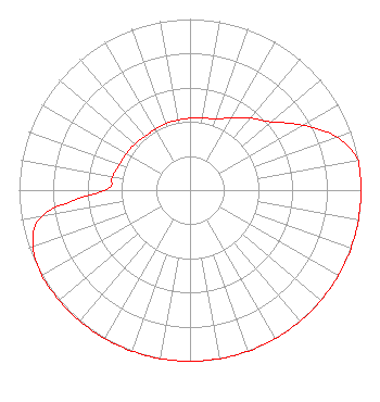 | ||||||||||||||||||
| Azimuth | Ratio | Azimuth | Ratio | Azimuth | Ratio | Azimuth | Ratio | ||||||||||||
| 0 | 0.420 | 10 | 0.430 | 20 | 0.440 | 30 | 0.490 | ||||||||||||
| 40 | 0.550 | 50 | 0.620 | 60 | 0.760 | 70 | 0.910 | ||||||||||||
| 80 | 1.000 | 90 | 1.000 | 100 | 1.000 | 110 | 1.000 | ||||||||||||
| 120 | 1.000 | 130 | 1.000 | 140 | 1.000 | 150 | 1.000 | ||||||||||||
| 160 | 1.000 | 170 | 1.000 | 180 | 1.000 | 190 | 1.000 | ||||||||||||
| 200 | 1.000 | 210 | 1.000 | 220 | 1.000 | 230 | 1.000 | ||||||||||||
| 240 | 1.000 | 250 | 0.975 | 260 | 0.875 | 270 | 0.500 | ||||||||||||
| 280 | 0.460 | 290 | 0.440 | 300 | 0.430 | 310 | 0.420 | ||||||||||||
| 320 | 0.410 | 330 | 0.410 | 340 | 0.415 | 350 | 0.415 | ||||||||||||
Structure Registration Number 1009976 Structure Type: TOWER Registered To: SVENDSEN, ERLING DBA = NORTH COUNTRY REPEATERS Structure Address: Summit Of Church Hill .25 N Of Perry Rd Bangor, NY County Name: Franklin County ASR Issued: 03/08/1997 Date Built: 04/01/1991 Site Elevation: 332 m (1089 ft.) Structure Height: 36.5 m (120 ft.) Height Overall: 43.3 m (142 ft.) Overall Height AMSL: 375.3 m (1231 ft.) FAA Determination: 01/31/1991 FAA Study #: 90-AEA-2039-OE Paint & Light FAA Chapters: NONE 44-49-39.0 N 74-22-43.0 W (NAD 83) 44-49-38.8 N 74-22-44.4 W (Converted to NAD 27) |
Martz Communications Group 3531 S. Logan St., # D-320 Englewood, CO 80113 Phone: 775-742-1312 Corporation | Date: 11/29/2011 Application Certifier CARTIER COMMUNICATIONS INC. 955 South Virginia Street Suite 222 Reno, NV 89502 Applicant R. STUART GRAHAM Graham Brock, Inc. P. O. Box 24466 St. Simons Island, GA 31522-7466 TECHNICAL CONSULTANT DAVID G. O'NEIL, ESQ. Rini Coran, Pc 1140 19th Street, Nw Suite 600 Washington, DC 20036 | |||||||||||||||||