
FCCInfo.com
A Service of Cavell, Mertz & Associates, Inc.
(855) FCC-INFO
|
|
W248BM from 10/07/2009 W248BM from 08/24/2004 |
|
|
||||||||||||||||
|
|
W248BM Channel: 248D 97.5 MHz Murfreesboro, Tennessee Service: FX - A translator or application for a translator. Facility ID: 140645 Fac. Service: FX Programming Delivery Method: Unspecified Status: License Application Accepted: 11/07/2014 Application Granted: 12/01/2014 File Number: BLFT-20141107AEC License Expires: 00/00/0000 Prefix Type: This is a license for a translator Application Type: License To Cover FCC Website Links: LMS Facility Details This Application CDBS Application Other W248BM Applications Other W248BM Applications in CDBS Including Superseded Applications Mailing Address Correspondence for W248BM Correspondence related to application BLFT-20141107AEC Service Contour - Open Street Map or USGS Map (60 dBu) Service Contour - KML / Google Earth (60 dBu) Class: D, A Noncommercial educational operating with no more than 10W Site Location: 35-50-56.2 N 86-21-11.0 W (NAD 83) Site Location: 35-50-56.0 N 86-21-11.0 W (Converted to NAD 27) Effective Radiated Power: 0.25 kW Transmitter Output Power: 0.224 kW Antenna Center HAAT: 0 m Antenna Center AMSL: 275 m (902 ft.) Antenna Center HAG: 83 m (272 ft.) Site Elevation: 192 m. (630 ft.) Height Overall*: 88 m (289 ft.) (* As Filed In This Application, may differ from ASR Data, Below.) Directional Antenna Antenna Make/Model: None Antenna ID: 119673 Polarization:
| ||||||||||||||||||
| Antenna Data for Antenna Id: 119673 W248BM FX File: BLFT-20141107AEC None - Service: FX | 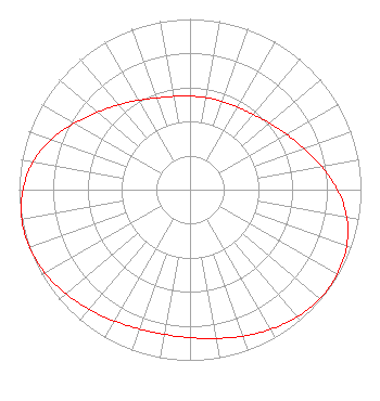 | ||||||||||||||||||
| Azimuth | Ratio | Azimuth | Ratio | Azimuth | Ratio | Azimuth | Ratio | ||||||||||||
| 0 | 0.548 | 10 | 0.547 | 20 | 0.550 | 30 | 0.558 | ||||||||||||
| 40 | 0.575 | 50 | 0.608 | 60 | 0.651 | 70 | 0.707 | ||||||||||||
| 80 | 0.781 | 90 | 0.862 | 100 | 0.931 | 110 | 0.974 | ||||||||||||
| 120 | 0.994 | 130 | 0.993 | 140 | 0.974 | 150 | 0.945 | ||||||||||||
| 160 | 0.913 | 170 | 0.885 | 180 | 0.867 | 190 | 0.861 | ||||||||||||
| 200 | 0.868 | 210 | 0.888 | 220 | 0.916 | 230 | 0.948 | ||||||||||||
| 240 | 0.978 | 250 | 0.997 | 260 | 0.999 | 270 | 0.977 | ||||||||||||
| 280 | 0.933 | 290 | 0.864 | 300 | 0.780 | 310 | 0.705 | ||||||||||||
| 320 | 0.649 | 330 | 0.604 | 340 | 0.572 | 350 | 0.555 | ||||||||||||
Structure Registration Number 1061283 [ASR Heights Differ from W248BM Application] Structure Type: TOWER Registered To: MIDDLE TENNESSEE STATE UNIVERSITY DBA = (C/O RADIO STATION WMTS) Structure Address: N. Rutherford Blvd. (at Mtsu 2nd St. Intersection) Murfreesboro, TN County Name: Rutherford County ASR Issued: 03/04/1999 Date Built: 12/01/1971 Site Elevation: 192 m (630 ft.) Structure Height: 87.2 m (286 ft.) Height Overall: 87.5 m (287 ft.) Overall Height AMSL: 279.5 m (917 ft.) FAA Determination: 09/28/1993 FAA Study #: 93-ASO-1751-OE FAA Circular #: 70/7460-1H Paint & Light FAA Chapters: 3, 4, 5, 13 RED LIGHTS/PAINT 35-50-56.0 N 86-21-11.0 W (NAD 83) 35-50-55.8 N 86-21-11.0 W (Converted to NAD 27) |
P.o. Box 150846 Nashville, TN 37215 Phone: 615-361-7560 Corporation | Date: 11/07/2014 Application Certifier MONTGOMERY BROADCASTING COMPANY P.o. Box 150846 Nashville, TN 37215 Applicant CHARLES M. ANDERSON Anderson Associates 1519 Euclid Avenue Bowling Green, KY 42103 CONSULTANT JOHN GARZIGLIA Womble Carlyle Sandridge & Rice, Llp 1200 19th Street, N.w., Suite 500 Washington, DC 20036 | |||||||||||||||||