
FCCInfo.com
A Service of Cavell, Mertz & Associates, Inc.
(855) FCC-INFO
|
|
K213DF from 10/30/1997 K213DF from 04/17/1997 |
|
|
||||||||||||||||
|
|
K213DF Channel: 213D 90.5 MHz Kalispell, Montana Service: FX - A translator or application for a translator. Facility ID: 86636 Fac. Service: FX Programming Delivery Method: Unspecified Status: License Application Accepted: 11/16/2000 Application Granted: 12/08/2000 File Number: BLFT-20000901AKP License Expires: 00/00/0000 Prefix Type: This is a license for a translator Application Type: License To Cover FCC Website Links: LMS Facility Details This Application CDBS Application Other K213DF Applications Other K213DF Applications in CDBS Including Superseded Applications Mailing Address Correspondence for K213DF Correspondence related to application BLFT-20000901AKP Service Contour - Open Street Map or USGS Map (60 dBu) Service Contour - KML / Google Earth (60 dBu) Class: D, A Noncommercial educational operating with no more than 10W Site Location: 48-10-32.8 N 114-21-01.5 W (NAD 83) Site Location: 48-10-33.0 N 114-20-58.0 W (Converted to NAD 27) Effective Radiated Power: 0 kW Horiz. ; 0.003 kW Vert. Transmitter Output Power: 0.002 kW Antenna Center HAAT: 119 m Horiz.; 0 m Vert. Antenna Center AMSL: 0 m Horiz.; 1168 m Vert. Antenna Center HAG: 0 m Horiz.; 41 m Vert. Site Elevation: 1127 m. (3698 ft.) Height Overall*: 46 m (151 ft.) (* As Filed In This Application, may differ from ASR Data, Below.) Directional Antenna Antenna Make/Model: None Antenna ID: 16130 Polarization:
| ||||||||||||||||||
| Antenna Data for Antenna Id: 16130 K213DF FX File: BLFT-20000901AKP None - Service: FX Pattern and Field Values Include a 75° Clockwise Rotation | 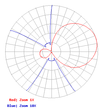 | ||||||||||||||||||
| Azimuth | Ratio | Azimuth | Ratio | Azimuth | Ratio | Azimuth | Ratio | ||||||||||||
| 5 | 0.185 | 15 | 0.410 | 25 | 0.600 | 35 | 0.735 | ||||||||||||
| 45 | 0.840 | 55 | 0.923 | 65 | 0.980 | 75 | 1.000 | ||||||||||||
| 85 | 0.980 | 95 | 0.923 | 105 | 0.840 | 115 | 0.735 | ||||||||||||
| 125 | 0.600 | 135 | 0.410 | 145 | 0.185 | 155 | 0.030 | ||||||||||||
| 165 | 0.020 | 175 | 0.020 | 185 | 0.020 | 195 | 0.020 | ||||||||||||
| 205 | 0.025 | 215 | 0.125 | 225 | 0.195 | 235 | 0.230 | ||||||||||||
| 245 | 0.250 | 255 | 0.260 | 265 | 0.250 | 275 | 0.230 | ||||||||||||
| 285 | 0.195 | 295 | 0.125 | 305 | 0.025 | 315 | 0.020 | ||||||||||||
| 325 | 0.020 | 335 | 0.020 | 345 | 0.020 | 355 | 0.030 | ||||||||||||
Structure Registration Number 1014770 [ASR Heights Differ from K213DF Application] Structure Type: TOWER Registered To: CCATT LLC Structure Address: Lone Pine State Park Kalispell, MT County Name: Flathead County ASR Issued: 05/09/2016 Date Built: 06/22/2010 Site Elevation: 1131.1 m (3711 ft.) Structure Height: 40.5 m (133 ft.) Height Overall: 44.5 m (146 ft.) Overall Height AMSL: 1175.6 m (3857 ft.) FAA Determination: 08/23/2011 FAA Study #: 2011-ANM-1639-OE FAA Circular #: 70/7460-1K Paint & Light FAA Chapters: 4, 5, 12 PRIOR STUDY 2001-ANM-3033-OE 48-10-32.5 N 114-21-01.4 W (NAD 83) 48-10-32.7 N 114-20-57.9 W (Converted to NAD 27) |
250 Brent Lane Pensacola, FL 32503 | Date: 09/01/2000 Application Certifier PENSACOLA CHRISTIAN COLLEGE, INC. 250 Brent Lane Pensacola, FL 32503 Applicant PRESIDENT | |||||||||||||||||