
FCCInfo.com
A Service of Cavell, Mertz & Associates, Inc.
(855) FCC-INFO
|
|
KMCS from 12/08/1995 |
|
|
||||||||||||||||
|
|
KMCS Channel: 226A 93.1 MHz Muscatine, Iowa Service: FM - A full-service FM station or application. Facility ID: 47086 Fac. Service: FM Status: License 73.215 Station Application Accepted: 06/06/1996 Application Granted: 01/15/1998 File Number: BLH-19960606KB License Expires: 00/00/0000 Prefix Type: This is a license for a commercial FM station Application Type: License To Cover FCC Website Links: LMS Facility Details This Application CDBS Application Other KMCS Applications Other KMCS Applications in CDBS Including Superseded Applications Mailing Address Correspondence for KMCS Correspondence related to application BLH-19960606KB Service Contour - Open Street Map or USGS Map (60 dBu) Service Contour - KML / Google Earth (60 dBu) Public Inspection Files Facility Type: FM STATION Class: A, A Zone I; I-A; or II station; with 0.1kW-6kW ERP and a class contour distance <=28km Site Location: 41-26-34.1 N 91-04-33.5 W (NAD 83) Site Location: 41-26-34.0 N 91-04-33.0 W (Converted to NAD 27) Effective Radiated Power: 4.4 kW Antenna Center HAAT: 117 m (384 ft.) Antenna Center AMSL: 310 m (1017 ft.) Antenna Center HAG: 104 m (341 ft.) Calculated Site Elevation: 206 m. (676 ft.) Height Overall*: 108 m (354 ft.) (* As Filed In This Application, may differ from ASR Data, Below.) Directional Antenna Antenna Make/Model: Oddball; usually designed by Applicant ODD941227ME Antenna ID: 14722 Polarization: | ||||||||||||||||||
| Antenna Data for Antenna Id: 14722 KMCS FM File: BLH-19960606KB Oddball; usually designed by Applicant - ODD941227ME Service: FM | 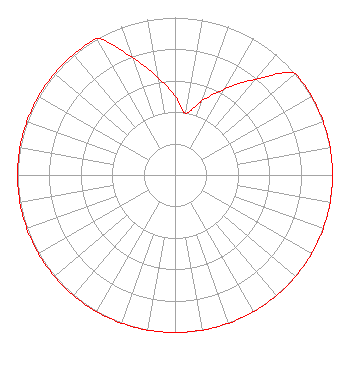 | ||||||||||||||||||
| Azimuth | Ratio | Azimuth | Ratio | Azimuth | Ratio | Azimuth | Ratio | ||||||||||||
| 0 | 0.501 | 10 | 0.398 | 20 | 0.501 | 30 | 0.631 | ||||||||||||
| 40 | 0.794 | 50 | 1.000 | 60 | 1.000 | 70 | 1.000 | ||||||||||||
| 80 | 1.000 | 90 | 1.000 | 100 | 1.000 | 110 | 1.000 | ||||||||||||
| 120 | 1.000 | 130 | 1.000 | 140 | 1.000 | 150 | 1.000 | ||||||||||||
| 160 | 1.000 | 170 | 1.000 | 180 | 1.000 | 190 | 1.000 | ||||||||||||
| 200 | 1.000 | 210 | 1.000 | 220 | 1.000 | 230 | 1.000 | ||||||||||||
| 240 | 1.000 | 250 | 1.000 | 260 | 1.000 | 270 | 1.000 | ||||||||||||
| 280 | 1.000 | 290 | 1.000 | 300 | 1.000 | 310 | 1.000 | ||||||||||||
| 320 | 1.000 | 330 | 1.000 | 340 | 0.794 | 350 | 0.631 | ||||||||||||
Structure Registration Number 1017248 Structure Type: TOWER Registered To: JAM Media Solutions, LLC Structure Address: 3218 Mulberry Ave Muscatine, IA County Name: Muscatine County ASR Issued: 08/14/2019 Date Built: 01/15/1983 Site Elevation: 206 m (676 ft.) Structure Height: 106.7 m (350 ft.) Height Overall: 108 m (354 ft.) Overall Height AMSL: 314 m (1030 ft.) Paint & Light FAA Chapters: 1, 3, 12, 21 41-26-34.0 N 91-04-34.0 W (NAD 83) 41-26-33.9 N 91-04-33.5 W (Converted to NAD 27) |
Mccarter & English, Llp Four Gateway Center, 100 Mulberry Street Newark, NJ 07102 Phone: 973-639-7939 Trustee in Chapter 7 Bankruptcy | Date: 06/06/1996 Application Certifier MUSCATINE COMMUNICATIONS, INC. Muscatine Communications, Inc. 3218 Mulberry Avenue Muscatine, IA 52761 Applicant | |||||||||||||||||