
FCCInfo.com
A Service of Cavell, Mertz & Associates, Inc.
(855) FCC-INFO
|
|
WCXK from 10/04/1996 |
|
|
||||||||||||||||
|
|
WCXK Channel: 202B1 88.3 MHz Kalamazoo, Michigan Service: FM - A full-service FM station or application. Facility ID: 24786 Fac. Service: FM Status: License Application Accepted: 01/07/1997 Application Granted: 04/11/1997 File Number: BLED-19970107KA License Expires: 00/00/0000 Prefix Type: This is a license for a noncommercial educational FM station Application Type: License To Cover FCC Website Links: LMS Facility Details This Application CDBS Application Other WCXK Applications Other WCXK Applications in CDBS Including Superseded Applications Mailing Address Correspondence for WCXK Correspondence related to application BLED-19970107KA Service Contour - Open Street Map or USGS Map (60 dBu) Service Contour - KML / Google Earth (60 dBu) Public Inspection Files Facility Type: NON-COMMERCIAL EDUC. FM Class: B1, A Zone I or I-A station; with 6kW-25kW ERP and a class contour distance 28km-39km Site Location: 42-18-23.1 N 85-39-25.0 W (NAD 83) Site Location: 42-18-23.0 N 85-39-25.0 W (Converted to NAD 27) Effective Radiated Power: 0 kW Horiz. ; 10 kW Vert. Transmitter Output Power: 1.8 kW Antenna Center HAAT: 0 m Horiz.; 121 m Vert. Antenna Center AMSL: 0 m Horiz.; 380 m Vert. Antenna Center HAG: 0 m Horiz.; 81 m Vert. Calculated Site Elevation: m. Height Overall*: 140 m (459 ft.) (* As Filed In This Application, may differ from ASR Data, Below.) Directional Antenna Antenna Make/Model: Oddball; usually designed by Applicant ODD900302ME Antenna ID: 14078 Polarization:
| ||||||||||||||||||
| Antenna Data for Antenna Id: 14078 WCXK FM File: BLED-19970107KA Oddball; usually designed by Applicant - ODD900302ME Service: FM | 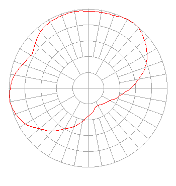 | ||||||||||||||||||
| Azimuth | Ratio | Azimuth | Ratio | Azimuth | Ratio | Azimuth | Ratio | ||||||||||||
| 0 | 0.970 | 10 | 0.970 | 20 | 0.975 | 30 | 1.000 | ||||||||||||
| 40 | 0.990 | 50 | 0.930 | 60 | 0.860 | 70 | 0.770 | ||||||||||||
| 80 | 0.650 | 90 | 0.545 | 100 | 0.440 | 110 | 0.380 | ||||||||||||
| 120 | 0.320 | 130 | 0.290 | 140 | 0.270 | 150 | 0.255 | ||||||||||||
| 160 | 0.265 | 170 | 0.320 | 180 | 0.360 | 190 | 0.435 | ||||||||||||
| 200 | 0.520 | 210 | 0.600 | 220 | 0.710 | 230 | 0.800 | ||||||||||||
| 240 | 0.910 | 250 | 0.970 | 260 | 1.000 | 270 | 0.980 | ||||||||||||
| 280 | 0.940 | 290 | 0.875 | 300 | 0.830 | 302 | 0.830 | ||||||||||||
| 310 | 0.870 | 320 | 0.930 | 330 | 0.960 | 340 | 0.970 | ||||||||||||
| 350 | 0.980 | ||||||||||||||||||
Structure Registration Number 1012375 [ASR Heights Differ from WCXK Application] Structure Type: GTOWER Registered To: GRAND VALLEY STATE UNIVERSITY BOARD OF CONTROL Structure Address: 5656 Beech Rd Kalamazoo, MI County Name: Kalamazoo County ASR Issued: 03/14/2024 Date Built: 12/01/2002 Site Elevation: 298.7 m (980 ft.) Structure Height: 134.1 m (440 ft.) Height Overall: 143 m (469 ft.) Overall Height AMSL: 441.7 m (1449 ft.) FAA Determination: 09/09/2014 FAA Study #: 2014-AGL-10448-OE FAA Circular #: 70/7460-1K Paint & Light FAA Chapters: 4, 8, 12 PRIOR STUDY 2003-AGL-6778-OE CHAPTERS 4,8,12 (1K) ADD SPECIAL CONDITION FOR LIGHTING DEVIATION. 42-18-23.1 N 85-39-25.0 W (NAD 83) 42-18-23.0 N 85-39-25.0 W (Converted to NAD 27) |
1159 E Beltline Ave Ne Grand Rapids, MI 49525-5805 Phone: 616-942-1500 | Date: 01/07/1997 Application Certifier CORNERSTONE BAPTIST EDUC. MINISTRIES Cornerstone Baptist Educcational Ministries 1001 E. Beltline Ave. Ne Grand Rapids, MI 49505-5803 Applicant | |||||||||||||||||