
FCCInfo.com
A Service of Cavell, Mertz & Associates, Inc.
(855) FCC-INFO
|
|
KVIT from 02/20/2015 |
|  |
|
|||||||||||||||
|
|
KVIT Channel: 204C3 88.7 MHz Chandler, Arizona Service: FM - A full-service FM station or application. Facility ID: 173984 Fac. Service: FM Status: License Application Accepted: 08/12/2015 Application Granted: 08/20/2015 File Number: BLED-20150812AAS License Expires: 00/00/0000 Prefix Type: This is a license for a noncommercial educational FM station Application Type: License To Cover FCC Website Links: LMS Facility Details This Application CDBS Application Other KVIT Applications Other KVIT Applications in CDBS Including Superseded Applications Mailing Address Correspondence for KVIT Correspondence related to application BLED-20150812AAS Service Contour - Open Street Map or USGS Map (60 dBu) Service Contour - KML / Google Earth (60 dBu) Public Inspection Files Facility Type: NON-COMMERCIAL EDUC. FM Class: C3, A Zone II station; with 6kW-25kW ERP and a class contour distance 28km-39km Site Location: 33-00-14.2 N 111-58-55.5 W (NAD 83) Site Location: 33-00-14.0 N 111-58-53.0 W (Converted to NAD 27) Effective Radiated Power: 15 kW Transmitter Output Power: 5.75 kW Antenna Center HAAT: 113 m (371 ft.) Antenna Center AMSL: 503 m (1650 ft.) Antenna Center HAG: 129 m (423 ft.) Calculated Site Elevation: 374 m. (1227 ft.) Height Overall*: 187 m (614 ft.) (* As Filed In This Application, may differ from ASR Data, Below.) Directional Antenna Antenna Make/Model: Electronics Research Inc. LP-4E-DA Antenna ID: 121512 Polarization: | ||||||||||||||||||
| Antenna Data for Antenna Id: 121512 KVIT FM File: BLED-20150812AAS Electronics Research Inc. - LP-4E-DA Service: FM | 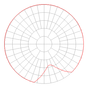 | ||||||||||||||||||
| Azimuth | Ratio | Azimuth | Ratio | Azimuth | Ratio | Azimuth | Ratio | ||||||||||||
| 0 | 1.000 | 10 | 1.000 | 20 | 1.000 | 30 | 1.000 | ||||||||||||
| 40 | 1.000 | 50 | 1.000 | 60 | 1.000 | 70 | 1.000 | ||||||||||||
| 80 | 1.000 | 90 | 1.000 | 100 | 1.000 | 110 | 1.000 | ||||||||||||
| 120 | 1.000 | 130 | 1.000 | 135 | 1.000 | 140 | 0.902 | ||||||||||||
| 150 | 0.716 | 160 | 0.569 | 170 | 0.569 | 180 | 0.716 | ||||||||||||
| 190 | 0.902 | 195 | 1.000 | 200 | 1.000 | 210 | 1.000 | ||||||||||||
| 220 | 1.000 | 230 | 1.000 | 240 | 1.000 | 250 | 1.000 | ||||||||||||
| 260 | 1.000 | 270 | 1.000 | 280 | 1.000 | 290 | 1.000 | ||||||||||||
| 300 | 1.000 | 310 | 1.000 | 320 | 1.000 | 330 | 1.000 | ||||||||||||
| 340 | 1.000 | 350 | 1.000 | ||||||||||||||||
Structure Registration Number 1062272 Structure Type: TOWER Registered To: East Valley Institute of Technology Structure Address: 14210 N Fuqua Rd Maricopa, AZ County Name: Pinal County ASR Issued: 12/02/2020 Date Built: 01/20/1995 Site Elevation: 374 m (1227 ft.) Structure Height: 186.8 m (613 ft.) Height Overall: 186.8 m (613 ft.) Overall Height AMSL: 560.8 m (1840 ft.) FAA Determination: 03/15/1999 FAA Study #: 99-AWP-0242-OE FAA Circular #: 70/7460-1H Paint & Light FAA Chapters: 3, 4, 5, 13 REFER TO PRIOR STUDY 94-AWP-1568-OE. 33-00-14.0 N 111-58-56.0 W (NAD 83) 33-00-13.8 N 111-58-53.5 W (Converted to NAD 27) |
1601 West Main Street Mesa, AZ 85201 Phone: 480-461-4000 | Date: 08/12/2015 Application Certifier EAST VALLEY INSTITUTE OF TECHNOLOGY DISTRICT #401 1601 W Main St Mesa, AZ 85201 Applicant ERIK C. SWANSON, P.E. Hatfield & Dawson Consulting Engineers, 9500 Greenwood Ave N Seattle, WA 98103 CONSULTING ENGINEER STEVE GROSZ East Valley Institute Of Technology | |||||||||||||||||