|
WFDU Channel: 206B1 89.1 MHz
Teaneck, New Jersey
Service: FM - A full-service FM station or application.
Facility ID: 20458
FRN: 0010296713
Fac. Service: FM Analog & Digital
Status: LIC
Application Accepted: 11/03/2015
Application Granted: 11/10/2015
File Number: BLED-20151103AYC
License Expires: 06/01/2030
Prefix Type: This is a license for a noncommercial educational FM station
Application Type: License To Cover
FCC Website Links:
LMS Facility Details
This Application
Other WFDU Applications
Including Superseded Applications
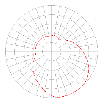
Service Contour - Open Street Map or USGS Map (60 dBu)
Service Contour - KML / Google Earth (60 dBu)
Public Inspection Files
Facility Type: NON-COMMERCIAL EDUC. FM
Class: B1, A Zone I or I-A station; with 6kW-25kW ERP and a class contour distance 28km-39km
Site Location: 40-57-39.4 N 73-55-21.5 W (NAD 83)
Site Location: 40-57-39.0 N 73-55-23.0 W (Converted to NAD 27)
Effective Radiated Power: 3 kW
Transmitter Output Power: 1.7 kW
Antenna Center HAAT: 195 m (640 ft.)
Antenna Center AMSL: 235.5 m (773 ft.)
Antenna Center HAG: 77 m (253 ft.)
Calculated Site Elevation: 158.5 m. (520 ft.)
Height Overall*: 129.6 m (425 ft.)
(* As Filed In This Application, may differ from ASR Data, Below.)
Directional Antenna
Antenna Make/Model: Propagation System Inc FML-2C-50WS-H-DA, 2 bays,.5 wavelength spaced
Antenna ID: 122111
Polarization:
|
Structure Information
Structure Registration Number 1048672
Structure Type: TOWER
Registered To:
K2 Towers II, LLC
Structure Address:
Us Rt 9w
Alpine, NJ
County Name: Bergen County
ASR Issued: 12/24/2019
Date Built: 05/22/2003
Site Elevation: 158.5 m (520 ft.)
Structure Height: 121.9 m (400 ft.)
Height Overall: 129.6 m (425 ft.)
Overall Height AMSL: 288.1 m (945 ft.)
FAA Determination: 06/03/2003
FAA Study #: 2001-AEA-3702-OE
FAA Circular #: 70/7460-1K
Paint & Light FAA Chapters: 3, 4, 5, 12
PRIOR STUDY 73-AEA-1004-OE
40-57-39.0 N 73-55-21.0 W (NAD 83)
40-57-38.6 N 73-55-22.5 W
(Converted to NAD 27)
|
WFDU(FM) Licensee Information
Fairleigh Dickinson University
1000 River Road
Teaneck, NJ 07666
Phone: 201-692-2000
Private Not-for-Profit Educational Institution | 20151103AYC Applicant Information
Angelo Carfagna
Date: 11/03/2015
Application Certifier
Fairleigh Dickinson University
1000 River Road
Teaneck, NJ 07666
Applicant
Laura M. Mizrahi
Communications Technologies, Inc.
P. O. Box 1130
Marlton, NJ 08053
Technical Consultant
Malcolm G. Stevenson
Schwartz, Woods & Miller
|