
FCCInfo.com
A Service of Cavell, Mertz & Associates, Inc.
(855) FCC-INFO
|
|
WMXQ from 06/16/1999 WMXQ from 01/16/1986 |
|  |
|
|||||||||||||||
|
|
WMXQ Channel: 228A 93.5 MHz Hartford City, Indiana Service: FM - A full-service FM station or application. Facility ID: 70187 Fac. Service: FM Status: License 73.215 Station Application Accepted: 11/10/2016 Application Granted: 11/16/2016 File Number: BLH-20161110AAB License Expires: 00/00/0000 Prefix Type: This is a license for a commercial FM station Application Type: License To Cover FCC Website Links: LMS Facility Details This Application CDBS Application Other WMXQ Applications Other WMXQ Applications in CDBS Including Superseded Applications Mailing Address Correspondence for WMXQ Correspondence related to application BLH-20161110AAB Service Contour - Open Street Map or USGS Map (60 dBu) Service Contour - KML / Google Earth (60 dBu) Public Inspection Files History Cards for WMXQ Facility Type: FM STATION Class: A, A Zone I; I-A; or II station; with 0.1kW-6kW ERP and a class contour distance <=28km Site Location: 40-25-16.2 N 85-25-39.9 W (NAD 83) Site Location: 40-25-16.0 N 85-25-40.0 W (Converted to NAD 27) Effective Radiated Power: 3.4 kW Transmitter Output Power: 1.75 kW Antenna Center HAAT: 134.6 m (442 ft.) Antenna Center AMSL: 408 m (1339 ft.) Antenna Center HAG: 131 m (430 ft.) Calculated Site Elevation: 277 m. (909 ft.) Height Overall*: 134 m (440 ft.) (* As Filed In This Application, may differ from ASR Data, Below.) Directional Antenna Antenna Make/Model: Jampro JMPC-3T (DA) Antenna ID: 125693 Polarization:
| ||||||||||||||||||
| Antenna Data for Antenna Id: 125693 WMXQ FM File: BLH-20161110AAB Jampro - JMPC-3T (DA) Service: FM | 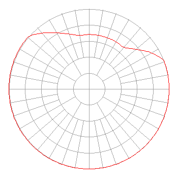 | ||||||||||||||||||
| Azimuth | Ratio | Azimuth | Ratio | Azimuth | Ratio | Azimuth | Ratio | ||||||||||||
| 0 | 0.680 | 10 | 0.680 | 20 | 0.680 | 30 | 0.680 | ||||||||||||
| 40 | 0.680 | 50 | 0.770 | 60 | 0.900 | 70 | 1.000 | ||||||||||||
| 80 | 1.000 | 90 | 1.000 | 100 | 1.000 | 110 | 1.000 | ||||||||||||
| 120 | 1.000 | 130 | 1.000 | 140 | 1.000 | 150 | 1.000 | ||||||||||||
| 160 | 1.000 | 170 | 1.000 | 180 | 1.000 | 190 | 1.000 | ||||||||||||
| 200 | 1.000 | 210 | 1.000 | 220 | 1.000 | 230 | 1.000 | ||||||||||||
| 240 | 1.000 | 250 | 1.000 | 260 | 1.000 | 270 | 1.000 | ||||||||||||
| 280 | 1.000 | 290 | 1.000 | 300 | 1.000 | 310 | 1.000 | ||||||||||||
| 320 | 0.910 | 330 | 0.810 | 340 | 0.730 | 350 | 0.680 | ||||||||||||
Structure Registration Number 1030894 Structure Type: TOWER Registered To: Woof Boom Radio Muncie License LLC Structure Address: Blackford Cr 200s W Of Angling Pike Hartford City, IN County Name: Blackford County ASR Issued: 12/20/2013 Date Built: 04/24/2012 Site Elevation: 277 m (909 ft.) Structure Height: 133.8 m (439 ft.) Height Overall: 133.8 m (439 ft.) Overall Height AMSL: 410.8 m (1348 ft.) FAA Determination: 06/01/1987 FAA Study #: 87-AGL-189-OE FAA Circular #: 70/7460-1G Paint & Light FAA Chapters: 3, 4, 5, 9 40-25-16.0 N 85-25-40.0 W (NAD 83) 40-25-15.8 N 85-25-40.1 W (Converted to NAD 27) |
800 East 29th Street Muncie, IN 47302 Phone: 765-288-4403 | Date: 11/10/2016 Application Certifier WOOF BOOM RADIO MUNCIE LICENSE LLC 800 East 29th Street Muncie, IN 47302 Applicant JEREMY D. RUCK, PE Jeremy Ruck & Associates, Inc. P.o. Box 415 Canton, IL 61520 CONSULTING ENGINEER JOHN C. TRENT, ESQ. Putbrese Hunsaker & Trent, P.c. | |||||||||||||||||
|
| ||||||||||||||||||