
FCCInfo.com
A Service of Cavell, Mertz & Associates, Inc.
(855) FCC-INFO
|
|
K264CG from 11/22/2013 |
|
|
||||||||||||||||
|
|
K264CG Channel: 264D 100.7 MHz Fernley, Nevada Service: FX - A translator or application for a translator. Facility ID: 142426 Fac. Service: FX Programming Delivery Method: Unspecified Status: License Application Accepted: 11/03/2016 Application Granted: 11/15/2016 File Number: BLFT-20161103ABK License Expires: 00/00/0000 Prefix Type: This is a license for a translator Application Type: License To Cover FCC Website Links: LMS Facility Details This Application CDBS Application Other K264CG Applications Other K264CG Applications in CDBS Including Superseded Applications Mailing Address Correspondence for K264CG Correspondence related to application BLFT-20161103ABK Service Contour - Open Street Map or USGS Map (60 dBu) Service Contour - KML / Google Earth (60 dBu) Class: D, A Noncommercial educational operating with no more than 10W Site Location: 39-29-16.7 N 119-17-51.6 W (NAD 83) Site Location: 39-29-17.0 N 119-17-48.0 W (Converted to NAD 27) Effective Radiated Power: 0 kW Horiz. ; 0.01 kW Vert. Transmitter Output Power: 0.006 kW Antenna Center HAAT: 0 m Antenna Center AMSL: 0 m Horiz.; 2115 m Vert. Antenna Center HAG: 0 m Horiz.; 20 m Vert. Site Elevation: 2095 m. (6873 ft.) Height Overall*: 37 m (121 ft.) (* As Filed In This Application, may differ from ASR Data, Below.) Directional Antenna Antenna Make/Model: None Antenna ID: 16130 Polarization:
| ||||||||||||||||||
| Antenna Data for Antenna Id: 16130 K264CG FX File: BLFT-20161103ABK None - Service: FX Pattern and Field Values Include a 35° Clockwise Rotation | 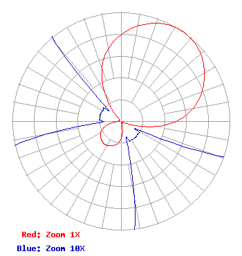 | ||||||||||||||||||
| Azimuth | Ratio | Azimuth | Ratio | Azimuth | Ratio | Azimuth | Ratio | ||||||||||||
| 5 | 0.840 | 15 | 0.923 | 25 | 0.980 | 35 | 1.000 | ||||||||||||
| 45 | 0.980 | 55 | 0.923 | 65 | 0.840 | 75 | 0.735 | ||||||||||||
| 85 | 0.600 | 95 | 0.410 | 105 | 0.185 | 115 | 0.030 | ||||||||||||
| 125 | 0.020 | 135 | 0.020 | 145 | 0.020 | 155 | 0.020 | ||||||||||||
| 165 | 0.025 | 175 | 0.125 | 185 | 0.195 | 195 | 0.230 | ||||||||||||
| 205 | 0.250 | 215 | 0.260 | 225 | 0.250 | 235 | 0.230 | ||||||||||||
| 245 | 0.195 | 255 | 0.125 | 265 | 0.025 | 275 | 0.020 | ||||||||||||
| 285 | 0.020 | 295 | 0.020 | 305 | 0.020 | 315 | 0.030 | ||||||||||||
| 325 | 0.185 | 335 | 0.410 | 345 | 0.600 | 355 | 0.735 | ||||||||||||
Structure Registration Number 1030145 Structure Type: TOWER Registered To: High Sierra Communications, Inc. Structure Address: 4.0 Miles On Bearing N270e From Town Of Silver Springs, NV County Name: Lyon County ASR Issued: 11/16/2013 Date Built: 05/26/1999 Site Elevation: 2095 m (6873 ft.) Structure Height: 30.5 m (100 ft.) Height Overall: 36.6 m (120 ft.) Overall Height AMSL: 2131.6 m (6993 ft.) FAA Study #: N/A Paint & Light FAA Chapters: None 39-29-17.0 N 119-17-52.0 W (NAD 83) 39-29-17.3 N 119-17-48.4 W (Converted to NAD 27) |
4002 N. 3300 E. Twin Falls, ID 83301 Phone: 208-734-6633 Not-for-Profit | Date: 11/03/2016 Application Certifier CALVARY CHAPEL OF TWIN FALLS, INC P.o. Box 391 Twin Falls, ID 83303 Applicant LOIS MILLS Po Box 391 Twin Falls, ID 83303 APPLICATION TECHNICIAN CARY TEPPER Tepper Law Firm, Llc 4900 Auburn Avenue, Suite 100 Bethesda, MD 20814-2632 | |||||||||||||||||