
FCCInfo.com
A Service of Cavell, Mertz & Associates, Inc.
(855) FCC-INFO
|
|
KJGM from 10/28/2014 KJGM from 08/01/2013 |
|  |
|
|||||||||||||||
|
|
KJGM Channel: 202C1 88.3 MHz Bastrop, Louisiana Service: FM - A full-service FM station or application. Facility ID: 174146 Fac. Service: FM Status: License Application Accepted: 08/13/2013 Application Granted: 08/27/2013 File Number: BLED-20130813ABU License Expires: 00/00/0000 Prefix Type: This is a license for a noncommercial educational FM station Application Type: License To Cover FCC Website Links: LMS Facility Details This Application CDBS Application Other KJGM Applications Other KJGM Applications in CDBS Including Superseded Applications Mailing Address Correspondence for KJGM Correspondence related to application BLED-20130813ABU Service Contour - Open Street Map or USGS Map (60 dBu) Service Contour - KML / Google Earth (60 dBu) Public Inspection Files Facility Type: NON-COMMERCIAL EDUC. FM Class: C1, A Zone II station; with 50kW-100kW ERP and a class contour distance 52km-72km Site Location: 32-37-13.0 N 91-43-47.9 W (NAD 83) Site Location: 32-37-12.5 N 91-43-47.5 W (Converted to NAD 27) Effective Radiated Power: 0 kW Horiz. ; 63 kW Vert. Transmitter Output Power: 17.6 kW Antenna Center HAAT: 0 m Horiz.; 82 m Vert. Antenna Center AMSL: 0 m Horiz.; 106 m Vert. Antenna Center HAG: 0 m Horiz.; 80 m Vert. Calculated Site Elevation: m. Height Overall*: 110 m (361 ft.) (* As Filed In This Application, may differ from ASR Data, Below.) Directional Antenna Antenna Make/Model: Systems With Reliability Inc. FM10V/3, 3 sections, 0.5 wavelength spacing Antenna ID: 101187 Polarization: | ||||||||||||||||||
| Antenna Data for Antenna Id: 101187 KJGM FM File: BLED-20130813ABU Systems With Reliability Inc. - FM10V/3, 3 sections, 0.5 wavelength spacing Service: FM | 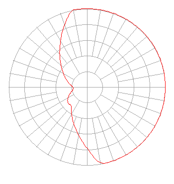 | ||||||||||||||||||
| Azimuth | Ratio | Azimuth | Ratio | Azimuth | Ratio | Azimuth | Ratio | ||||||||||||
| 0 | 1.000 | 10 | 1.000 | 20 | 1.000 | 30 | 1.000 | ||||||||||||
| 40 | 1.000 | 50 | 1.000 | 60 | 1.000 | 70 | 1.000 | ||||||||||||
| 80 | 1.000 | 90 | 1.000 | 100 | 1.000 | 110 | 1.000 | ||||||||||||
| 120 | 1.000 | 130 | 1.000 | 140 | 1.000 | 150 | 1.000 | ||||||||||||
| 160 | 1.000 | 170 | 0.977 | 180 | 0.780 | 190 | 0.622 | ||||||||||||
| 200 | 0.497 | 210 | 0.396 | 220 | 0.316 | 230 | 0.316 | ||||||||||||
| 240 | 0.282 | 250 | 0.226 | 260 | 0.182 | 270 | 0.182 | ||||||||||||
| 280 | 0.226 | 290 | 0.282 | 300 | 0.351 | 310 | 0.436 | ||||||||||||
| 320 | 0.543 | 330 | 0.676 | 340 | 0.841 | 350 | 1.000 | ||||||||||||
Structure Registration Number 1023957 [ASR Heights Differ from KJGM Application] Structure Type: LTOWER Registered To: VB-S1 Assets, LLC Structure Address: 4.0 Km E Oak Ridge, LA County Name: Morehouse Parish ASR Issued: 07/21/2020 Date Built: 03/30/1955 Site Elevation: 25.9 m (85 ft.) Structure Height: 83.8 m (275 ft.) Height Overall: 105.2 m (345 ft.) Overall Height AMSL: 131.1 m (430 ft.) FAA Determination: 08/24/2015 FAA Study #: 2015-ASW-6055-OE Paint & Light FAA Chapters: A1, H PRIOR STUDY 1989-ASW-1499-OE 32-37-13.0 N 91-43-48.0 W (NAD 83) 32-37-12.5 N 91-43-47.6 W (Converted to NAD 27) |
P.o. Box 262550 Baton Rouge, LA 70826-2550 Phone: 225-768-3102 | Date: 08/13/2013 Application Certifier GLORY2GLORY EDUCATIONAL FOUNDATION, INC. 6229 Justus Road Bastrop, LA 71220 Applicant R. STUART GRAHAM Graham Brock, Inc. P. O. Box 24466 St. Simons Island, GA 31522-7466 TECHNICAL CONSULTANT CHUCK HALLEY Glory2glory Educational Foundation, Inc. | |||||||||||||||||