
FCCInfo.com
A Service of Cavell, Mertz & Associates, Inc.
(855) FCC-INFO
|
|
W254BV from 08/01/2005 W254BV from 01/13/1998 |
|
|
||||||||||||||||
|
|
W254BV Channel: 254D 98.7 MHz Clayton, North Carolina Service: FX - A translator or application for a translator. Facility ID: 87682 Fac. Service: FX Programming Delivery Method: Unspecified Status: License Application Accepted: 10/11/2012 Application Granted: 10/24/2012 File Number: BLFT-20121011AAU License Expires: 00/00/0000 Prefix Type: This is a license for a translator Application Type: License To Cover FCC Website Links: LMS Facility Details This Application CDBS Application Other W254BV Applications Other W254BV Applications in CDBS Including Superseded Applications Mailing Address Correspondence for W254BV Correspondence related to application BLFT-20121011AAU Service Contour - Open Street Map or USGS Map (60 dBu) Service Contour - KML / Google Earth (60 dBu) Class: D, A Noncommercial educational operating with no more than 10W Site Location: 35-40-35.6 N 78-32-07.0 W (NAD 83) Site Location: 35-40-35.0 N 78-32-08.0 W (Converted to NAD 27) Effective Radiated Power: 0.25 kW Transmitter Output Power: 0.294 kW Antenna Center HAAT: 194.1 m Horiz.; 0 m Vert. Antenna Center AMSL: 274 m (899 ft.) Antenna Center HAG: 175 m (574 ft.) Site Elevation: 99 m. (325 ft.) Height Overall*: 610 m (2001 ft.) (* As Filed In This Application, may differ from ASR Data, Below.) Directional Antenna Antenna Make/Model: None Antenna ID: 109866 Polarization:
| ||||||||||||||||||
| Antenna Data for Antenna Id: 109866 W254BV FX File: BLFT-20121011AAU None - Service: FX Pattern and Field Values Include a 128° Clockwise Rotation | 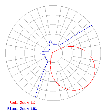 | ||||||||||||||||||
| Azimuth | Ratio | Azimuth | Ratio | Azimuth | Ratio | Azimuth | Ratio | ||||||||||||
| 8 | 0.018 | 18 | 0.019 | 28 | 0.021 | 38 | 0.021 | ||||||||||||
| 48 | 0.036 | 53 | 0.079 | 58 | 0.162 | 63 | 0.262 | ||||||||||||
| 68 | 0.359 | 73 | 0.460 | 78 | 0.548 | 88 | 0.703 | ||||||||||||
| 98 | 0.825 | 108 | 0.919 | 118 | 0.979 | 128 | 1.000 | ||||||||||||
| 138 | 0.979 | 148 | 0.919 | 158 | 0.825 | 168 | 0.703 | ||||||||||||
| 178 | 0.548 | 188 | 0.359 | 198 | 0.162 | 208 | 0.036 | ||||||||||||
| 218 | 0.021 | 228 | 0.019 | 238 | 0.018 | 248 | 0.018 | ||||||||||||
| 258 | 0.018 | 268 | 0.026 | 278 | 0.021 | 288 | 0.011 | ||||||||||||
| 298 | 0.010 | 308 | 0.010 | 318 | 0.010 | 328 | 0.011 | ||||||||||||
| 338 | 0.021 | 348 | 0.026 | 358 | 0.018 | ||||||||||||||
Structure Registration Number 1006703 [ASR Heights Differ from W254BV Application] Structure Type: TOWER Registered To: AUBURN TOWER PARTNERSHIP Structure Address: 5033 Tv Tower Rd Garner, NC County Name: Wake County ASR Issued: 07/09/2013 Date Built: 06/17/1991 Site Elevation: 98.7 m (324 ft.) Structure Height: 569.7 m (1869 ft.) Height Overall: 609.5 m (2000 ft.) Overall Height AMSL: 708.2 m (2323 ft.) FAA Determination: 09/24/2003 FAA Study #: 2003-ASO-4390-OE FAA Circular #: 70/7460-1G Paint & Light FAA Chapters: 4, 6, 9 Continue As Is OM&L = 24-HR HI-STROBES 35-40-35.1 N 78-32-07.2 W (NAD 83) 35-40-34.5 N 78-32-08.2 W (Converted to NAD 27) |
Po Box 7217 Lakeland, FL 33807-7217 Phone: 863-644-3464 | Date: 10/11/2012 Application Certifier RADIO TRAINING NETWORK, INC. P.o. Box 7217 Lakeland, FL 33807-7217 Applicant TED MCCALL His Radio 2420 Wade Hampton Blvd Greenville, SC 29615 ENGINEERING DIRECTOR A. WRAY FITCH III Gammon & Grange, P.c. 8280 Greensboro Drive, 7th Floor Mclean, VA 22102-3807 | |||||||||||||||||