
FCCInfo.com
A Service of Cavell, Mertz & Associates, Inc.
(855) FCC-INFO
|
|
|
|
|
||||||||||||||||
|
|
W228CK Channel: 228D 93.5 MHz Decatur, Illinois Service: FX - A translator or application for a translator. Facility ID: 139309 Fac. Service: FX Programming Delivery Method: Unspecified Status: License Application Accepted: 07/05/2018 Application Granted: 07/11/2018 File Number: BLFT-20180705AAH License Expires: 00/00/0000 Prefix Type: This is a license for a translator Application Type: License To Cover FCC Website Links: LMS Facility Details This Application CDBS Application Other W228CK Applications Other W228CK Applications in CDBS Including Superseded Applications Mailing Address Correspondence for W228CK Correspondence related to application BLFT-20180705AAH Service Contour - Open Street Map or USGS Map (60 dBu) Service Contour - KML / Google Earth (60 dBu) Class: D, A Noncommercial educational operating with no more than 10W Site Location: 39-47-11.1 N 88-59-29.3 W (NAD 83) Site Location: 39-47-11.0 N 88-59-29.0 W (Converted to NAD 27) Effective Radiated Power: 0.25 kW Transmitter Output Power: 0.791 kW Antenna Center HAAT: 0 m Antenna Center AMSL: 284 m (932 ft.) Antenna Center HAG: 73 m (240 ft.) Site Elevation: 211 m. (692 ft.) Height Overall*: 105 m (344 ft.) (* As Filed In This Application, may differ from ASR Data, Below.) Directional Antenna Antenna Make/Model: None Antenna ID: 129511 Polarization:
| ||||||||||||||||||
| Antenna Data for Antenna Id: 129511 W228CK FX File: BLFT-20180705AAH None - Service: FX | 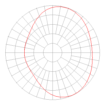 | ||||||||||||||||||
| Azimuth | Ratio | Azimuth | Ratio | Azimuth | Ratio | Azimuth | Ratio | ||||||||||||
| 0 | 0.953 | 10 | 0.982 | 20 | 0.988 | 30 | 0.974 | ||||||||||||
| 40 | 0.946 | 50 | 0.911 | 60 | 0.877 | 70 | 0.852 | ||||||||||||
| 80 | 0.840 | 90 | 0.841 | 100 | 0.857 | 110 | 0.885 | ||||||||||||
| 120 | 0.919 | 130 | 0.954 | 140 | 0.983 | 150 | 0.997 | ||||||||||||
| 160 | 0.989 | 170 | 0.957 | 180 | 0.900 | 190 | 0.822 | ||||||||||||
| 200 | 0.740 | 210 | 0.674 | 220 | 0.628 | 230 | 0.604 | ||||||||||||
| 240 | 0.594 | 250 | 0.593 | 260 | 0.595 | 270 | 0.596 | ||||||||||||
| 280 | 0.596 | 290 | 0.599 | 300 | 0.609 | 310 | 0.634 | ||||||||||||
| 320 | 0.679 | 330 | 0.744 | 340 | 0.822 | 350 | 0.898 | ||||||||||||
Structure Registration Number 1057133 Structure Type: TOWER Registered To: THE CROMWELL GROUP, INC. OF ILLINOIS Structure Address: 0.75 Miles N.w. Elwin, IL County Name: Macon County ASR Issued: 03/14/2017 Date Built: 05/03/2002 Site Elevation: 211 m (692 ft.) Structure Height: 104.2 m (342 ft.) Height Overall: 104.8 m (344 ft.) Overall Height AMSL: 315.8 m (1036 ft.) FAA Determination: 02/23/2001 FAA Study #: 01-AGL-0057-OE Paint & Light FAA Chapters: 1, 3, 11, 21 PRIOR STUDY 98-AGL-3508-OE PAINT/RED LIGHTS 39-47-10.9 N 88-59-29.4 W (NAD 83) 39-47-10.8 N 88-59-29.1 W (Converted to NAD 27) |
P.o. Box 150846 Nashville, TN 37215 Phone: 202-857-4455 | Date: 07/05/2018 Application Certifier THE CROMWELL GROUP, INC. OF ILLINOIS P.o. Box 150846 Nashville, TN 37215-0846 Applicant JERALD L. SCOTT 112 Country Club Dr. Pekin, IL 61554 CONSULTING ENGINEER JOHN F. GARZIGLIA, ESQ. Womble Bond Dickinson (us) Llp 1200 19th Street, N.w., Suite 500 Washington, DC 20036 | |||||||||||||||||