
FCCInfo.com
A Service of Cavell, Mertz & Associates, Inc.
(855) FCC-INFO
|
|
|
|  |
|
|||||||||||||||
|
|
WGBQ Channel: 220A 91.9 MHz Lynchburg, Tennessee Service: FM - A full-service FM station or application. Facility ID: 171691 Fac. Service: FM Status: License Application Accepted: 10/25/2010 Application Granted: 11/10/2010 File Number: BLED-20101025AAP License Expires: 00/00/0000 Prefix Type: This is a license for a noncommercial educational FM station Application Type: License To Cover FCC Website Links: LMS Facility Details This Application CDBS Application Other WGBQ Applications Other WGBQ Applications in CDBS Including Superseded Applications Mailing Address Correspondence for WGBQ Correspondence related to application BLED-20101025AAP Service Contour - Open Street Map or USGS Map (60 dBu) Service Contour - KML / Google Earth (60 dBu) Public Inspection Files Facility Type: NON-COMMERCIAL EDUC. FM Class: A, A Zone I; I-A; or II station; with 0.1kW-6kW ERP and a class contour distance <=28km Site Location: 35-16-32.3 N 86-21-37.0 W (NAD 83) Site Location: 35-16-32.0 N 86-21-37.0 W (Converted to NAD 27) Effective Radiated Power: 0.9 kW Transmitter Output Power: 0.487 kW Antenna Center HAAT: 107 m (351 ft.) Antenna Center AMSL: 395 m (1296 ft.) Antenna Center HAG: 47 m (154 ft.) Calculated Site Elevation: 348 m. (1142 ft.) Height Overall*: 106 m (348 ft.) (* As Filed In This Application, may differ from ASR Data, Below.) Directional Antenna Antenna Make/Model: Shivley 6810-2R-DA, two sections Antenna ID: 91196 Polarization:
| ||||||||||||||||||
| Antenna Data for Antenna Id: 91196 WGBQ FM File: BLED-20101025AAP Shivley - 6810-2R-DA, two sections Service: FM | 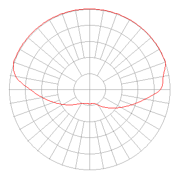 | ||||||||||||||||||
| Azimuth | Ratio | Azimuth | Ratio | Azimuth | Ratio | Azimuth | Ratio | ||||||||||||
| 0 | 1.000 | 10 | 1.000 | 20 | 1.000 | 30 | 1.000 | ||||||||||||
| 40 | 1.000 | 50 | 1.000 | 60 | 1.000 | 70 | 1.000 | ||||||||||||
| 80 | 0.930 | 90 | 0.880 | 100 | 0.700 | 110 | 0.560 | ||||||||||||
| 120 | 0.450 | 130 | 0.360 | 140 | 0.290 | 150 | 0.231 | ||||||||||||
| 160 | 0.187 | 170 | 0.180 | 180 | 0.180 | 190 | 0.178 | ||||||||||||
| 200 | 0.184 | 210 | 0.200 | 220 | 0.240 | 230 | 0.300 | ||||||||||||
| 240 | 0.375 | 250 | 0.470 | 260 | 0.590 | 270 | 0.740 | ||||||||||||
| 280 | 0.930 | 290 | 1.000 | 300 | 1.000 | 310 | 1.000 | ||||||||||||
| 320 | 1.000 | 330 | 1.000 | 340 | 1.000 | 350 | 1.000 | ||||||||||||
Structure Registration Number 1205709 [ASR Heights Differ from WGBQ Application] Structure Type: TOWER Registered To: Crown Communications LLC Structure Address: 926 Tanyard Hill Rd. Lynchburg, TN County Name: Moore County ASR Issued: 05/06/2016 Date Built: 09/23/2009 Site Elevation: 347.5 m (1140 ft.) Structure Height: 103.6 m (340 ft.) Height Overall: 106.4 m (349 ft.) Overall Height AMSL: 453.9 m (1489 ft.) FAA Determination: 07/16/2009 FAA Study #: 2009-ASO-3292-OE FAA Circular #: 70/7460-1K Paint & Light FAA Chapters: 4, 6, 12 PRIOR STUDY 2009-ASO-264-OE 35-16-32.3 N 86-21-36.5 W (NAD 83) 35-16-32.0 N 86-21-36.5 W (Converted to NAD 27) |
Po Drawer 2440 Tupelo, MS 38803 Phone: 662-844-8888 Not-for-Profit | Date: 10/25/2010 Application Certifier NETWORK OF GLORY 102 Red Branch Lane Simpsonville, SC 29681 Applicant RICHARD A. JESSE Po Box 347 Hartville, MO 65667-0347 CONSULTING ENGINEER RICHARD A. JESSE Javajava Radio | |||||||||||||||||