
FCCInfo.com
A Service of Cavell, Mertz & Associates, Inc.
(855) FCC-INFO
|
|
|
|  |
|
|||||||||||||||
|
|
WCWM Channel: 215B1 90.9 MHz Williamsburg, Virginia Service: FM - A full-service FM station or application. Facility ID: 65555 Fac. Service: FM Status: License Application Accepted: 10/22/2004 Application Granted: 10/27/2004 File Number: BLED-20041022ACN License Expires: 00/00/0000 Prefix Type: This is a license for a noncommercial educational FM station Application Type: License To Cover FCC Website Links: LMS Facility Details This Application CDBS Application Other WCWM Applications Other WCWM Applications in CDBS Including Superseded Applications Mailing Address Correspondence for WCWM Correspondence related to application BLED-20041022ACN Service Contour - Open Street Map or USGS Map (60 dBu) Service Contour - KML / Google Earth (60 dBu) Public Inspection Files History Cards for WCWM Facility Type: NON-COMMERCIAL EDUC. FM Class: B1, A Zone I or I-A station; with 6kW-25kW ERP and a class contour distance 28km-39km Site Location: 37-21-16.5 N 76-59-56.9 W (NAD 83) Site Location: 37-21-16.0 N 76-59-58.0 W (Converted to NAD 27) Effective Radiated Power: 13.5 kW Transmitter Output Power: 6.3 kW Antenna Center HAAT: 82 m (269 ft.) Antenna Center AMSL: 100 m (328 ft.) Antenna Center HAG: 72 m (236 ft.) Site Elevation: 27.7 m. (91 ft.) Height Overall*: 84.7 m (278 ft.) (* As Filed In This Application, may differ from ASR Data, Below.) Directional Antenna Antenna Make/Model: Shivley 6810-3R-SS-DA, 3 sections, 0.5 wavelength spaced Antenna ID: 59126 Polarization:
| ||||||||||||||||||
| Antenna Data for Antenna Id: 59126 WCWM FM File: BLED-20041022ACN Shivley - 6810-3R-SS-DA, 3 sections, 0.5 wavelength spaced Service: FM | 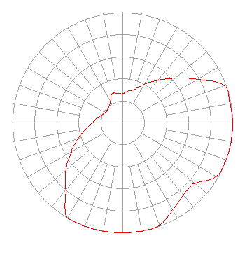 | ||||||||||||||||||
| Azimuth | Ratio | Azimuth | Ratio | Azimuth | Ratio | Azimuth | Ratio | ||||||||||||
| 0 | 0.260 | 10 | 0.290 | 20 | 0.320 | 30 | 0.400 | ||||||||||||
| 40 | 0.500 | 50 | 0.625 | 60 | 0.785 | 70 | 0.980 | ||||||||||||
| 80 | 0.990 | 90 | 1.000 | 100 | 1.000 | 110 | 1.000 | ||||||||||||
| 120 | 0.980 | 130 | 0.860 | 135 | 0.850 | 140 | 0.860 | ||||||||||||
| 150 | 0.914 | 160 | 0.990 | 170 | 1.000 | 180 | 1.000 | ||||||||||||
| 190 | 1.000 | 200 | 1.000 | 210 | 1.000 | 220 | 0.800 | ||||||||||||
| 230 | 0.670 | 240 | 0.535 | 250 | 0.427 | 260 | 0.340 | ||||||||||||
| 270 | 0.271 | 280 | 0.235 | 290 | 0.200 | 300 | 0.178 | ||||||||||||
| 310 | 0.180 | 320 | 0.190 | 330 | 0.220 | 340 | 0.275 | ||||||||||||
| 350 | 0.270 | ||||||||||||||||||
Structure Registration Number 1216502 [ASR Heights Differ from WCWM Application] Structure Type: TOWER Registered To: SBA Properties, LLC Structure Address: Route 614 Charles City, VA County Name: Charles City County ASR Issued: 04/25/2013 Date Built: 09/19/2000 Site Elevation: 27.7 m (91 ft.) Structure Height: 76.2 m (250 ft.) Height Overall: 79.2 m (260 ft.) Overall Height AMSL: 106.9 m (351 ft.) FAA Determination: 02/18/2000 FAA Study #: 99-AEA-3567-OE FAA Circular #: 70/7460-1J Paint & Light FAA Chapters: 4, 8, 13 PRIOR FAA # 99-AEA-1594 37-21-16.8 N 76-59-56.8 W (NAD 83) 37-21-16.3 N 76-59-57.9 W (Converted to NAD 27) |
203 Campus Center P.o. Box 8795 Williamsburg, VA 23187-8795 Private Not-for-Profit Educational Institution | Date: 10/22/2004 Application Certifier COLLEGE OF WILLIAM AND MARY C/o Mark Constantine 203 Campus Center, P.o. Box 8795 Williamsburg, VA 23187-8795 Applicant WILLIAM J. GETZ Carl T. Jones Corporation 7901 Yarnwood Court Springfield, VA 22153 TECHNICAL CONSULTANT DAVID D. OXENFORD, ESQ. Shaw Pittman Llp | |||||||||||||||||
| |||||||||||||||||||