
FCCInfo.com
A Service of Cavell, Mertz & Associates, Inc.
(855) FCC-INFO
|
|
|
|  |
|
|||||||||||||||
|
|
WRVT Channel: 204C2 88.7 MHz Rutland, Vermont Service: FM - A full-service FM station or application. Facility ID: 69953 Fac. Service: FM Analog & Digital Status: License Application Accepted: 12/06/2010 Application Granted: 12/14/2010 File Number: BLED-20101206ACJ License Expires: 00/00/0000 Prefix Type: This is a license for a noncommercial educational FM station Application Type: License To Cover FCC Website Links: LMS Facility Details This Application CDBS Application Other WRVT Applications Other WRVT Applications in CDBS Including Superseded Applications Mailing Address Correspondence for WRVT Correspondence related to application BLED-20101206ACJ Service Contour - Open Street Map or USGS Map (60 dBu) Service Contour - KML / Google Earth (60 dBu) Public Inspection Files Facility Type: NON-COMMERCIAL EDUC. FM Class: C2, A Zone II station; with 25kW-50kW ERP and a class contour distance 39km-52km Site Location: 43-39-31.2 N 73-06-23.4 W (NAD 83) Site Location: 43-39-31.0 N 73-06-25.0 W (Converted to NAD 27) Effective Radiated Power: 4 kW Horiz. ; 4.8 kW Vert. Transmitter Output Power: 2.83 kW Antenna Center HAAT: 412 m (1352 ft.) Antenna Center AMSL: 663 m (2175 ft.) Antenna Center HAG: 61 m (200 ft.) Calculated Site Elevation: 602 m. (1975 ft.) Height Overall*: 95 m (312 ft.) (* As Filed In This Application, may differ from ASR Data, Below.) Directional Antenna Antenna Make/Model: Shivley 6810 Antenna ID: 96884 Polarization:
| ||||||||||||||||||
| Antenna Data for Antenna Id: 96884 WRVT FM File: BLED-20101206ACJ Shivley - 6810 Service: FM | 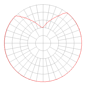 | ||||||||||||||||||
| Azimuth | Ratio | Azimuth | Ratio | Azimuth | Ratio | Azimuth | Ratio | ||||||||||||
| 0 | 0.408 | 10 | 0.514 | 20 | 0.647 | 30 | 0.814 | ||||||||||||
| 39 | 1.000 | 40 | 1.000 | 50 | 1.000 | 60 | 1.000 | ||||||||||||
| 70 | 1.000 | 80 | 1.000 | 90 | 1.000 | 100 | 1.000 | ||||||||||||
| 110 | 1.000 | 120 | 1.000 | 130 | 1.000 | 140 | 1.000 | ||||||||||||
| 150 | 1.000 | 160 | 1.000 | 170 | 1.000 | 180 | 1.000 | ||||||||||||
| 190 | 1.000 | 200 | 1.000 | 210 | 1.000 | 220 | 1.000 | ||||||||||||
| 230 | 1.000 | 240 | 1.000 | 250 | 1.000 | 260 | 1.000 | ||||||||||||
| 270 | 1.000 | 280 | 1.000 | 290 | 1.000 | 300 | 1.000 | ||||||||||||
| 310 | 1.000 | 314 | 1.000 | 320 | 0.880 | 330 | 0.699 | ||||||||||||
| 340 | 0.555 | 350 | 0.441 | ||||||||||||||||
Structure Registration Number 1210439 [ASR Heights Differ from WRVT Application] Structure Type: GTOWER Registered To: Vermont Public Co. Structure Address: Summit Of Grandpa Knob Castleton, VT County Name: Rutland County ASR Issued: 07/01/2021 Date Built: 09/01/2000 Site Elevation: 602 m (1975 ft.) Structure Height: 74.7 m (245 ft.) Height Overall: 87.2 m (286 ft.) Overall Height AMSL: 689.2 m (2261 ft.) FAA Determination: 07/24/2020 FAA Study #: 2020-ANE-4459-OE FAA Circular #: 70/7460-1L Paint & Light FAA Chapters: 4, 8, 12 43-39-31.5 N 73-06-23.6 W (NAD 83) 43-39-31.3 N 73-06-25.2 W (Converted to NAD 27) |
365 Troy Avenue Colchester, VT 05446 Phone: 802-654-4336 Not-for-Profit | Date: 12/06/2010 Application Certifier VERMONT PUBLIC RADIO 365 Troy Ave Colchester, VT 05446 Applicant RICH PARKER Vermont Public Radio 365 Troy Avenue Colchester, VT 05446 DIRECTOR OF ENGINEERING JOHN CRIGLER, ESQ. Garvey Schubert Barer | |||||||||||||||||