
FCCInfo.com
A Service of Cavell, Mertz & Associates, Inc.
(855) FCC-INFO
|
|
KQPR from 09/06/1989 |
|  |
|
|||||||||||||||||||||
|
|
KQPR Channel: 241C3 96.1 MHz Albert Lea, Minnesota Service: FM - A full-service FM station or application. Facility ID: 54473 Fac. Service: FM Status: License 73.215 Station Application Accepted: 03/17/2004 Application Granted: 03/29/2004 File Number: BLH-20040317AEQ License Expires: 00/00/0000 Prefix Type: This is a license for a commercial FM station Application Type: License To Cover FCC Website Links: LMS Facility Details This Application CDBS Application Other KQPR Applications Other KQPR Applications in CDBS Including Superseded Applications Mailing Address Correspondence for KQPR Correspondence related to application BLH-20040317AEQ Service Contour - Open Street Map or USGS Map (60 dBu) Service Contour - KML / Google Earth (60 dBu) Public Inspection Files Facility Type: FM STATION Class: C3, A Zone II station; with 6kW-25kW ERP and a class contour distance 28km-39km Site Location: 43-36-57.9 N 93-12-47.7 W (NAD 83) Site Location: 43-36-58.0 N 93-12-47.0 W (Converted to NAD 27) Effective Radiated Power: 25 kW Transmitter Output Power: 14.14 kW Antenna Center HAAT: 94 m (308 ft.) Antenna Center AMSL: 470 m (1542 ft.) Antenna Center HAG: 89 m (292 ft.) Calculated Site Elevation: 381 m. (1250 ft.) Height Overall*: 99.1 m (325 ft.) (* As Filed In This Application, may differ from ASR Data, Below.) Directional Antenna Antenna Make/Model: Electronics Research Inc. MP-4E-DA-HW, 4 sections, .5 wavelength spacing Antenna ID: 64346 Polarization: | ||||||||||||||||||||||||
| Antenna Data for Antenna Id: 64346 KQPR FM File: BLH-20040317AEQ Electronics Research Inc. - MP-4E-DA-HW, 4 sections, .5 wavelength spacing Service: FM | 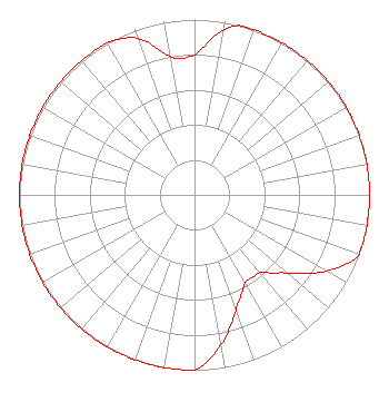 | ||||||||||||||||||||||||
| Azimuth | Ratio | Azimuth | Ratio | Azimuth | Ratio | Azimuth | Ratio | ||||||||||||||||||
| 0 | 0.800 | 10 | 0.950 | 15 | 1.000 | 20 | 1.000 | ||||||||||||||||||
| 30 | 1.000 | 40 | 1.000 | 50 | 1.000 | 60 | 1.000 | ||||||||||||||||||
| 70 | 1.000 | 80 | 1.000 | 90 | 1.000 | 100 | 1.000 | ||||||||||||||||||
| 110 | 1.000 | 120 | 0.870 | 130 | 0.700 | 135 | 0.630 | ||||||||||||||||||
| 140 | 0.580 | 150 | 0.580 | 155 | 0.630 | 160 | 0.700 | ||||||||||||||||||
| 170 | 0.870 | 180 | 1.000 | 190 | 1.000 | 200 | 1.000 | ||||||||||||||||||
| 210 | 1.000 | 220 | 1.000 | 230 | 1.000 | 240 | 1.000 | ||||||||||||||||||
| 250 | 1.000 | 260 | 1.000 | 270 | 1.000 | 280 | 1.000 | ||||||||||||||||||
| 290 | 1.000 | 300 | 1.000 | 310 | 1.000 | 320 | 1.000 | ||||||||||||||||||
| 330 | 1.000 | 340 | 0.950 | 350 | 0.800 | ||||||||||||||||||||
Structure Registration Number 1024056 Structure Type: TOWER Registered To: Hometown Broadcasting, Inc. Structure Address: 4.2 Km Sse Bearing 150 Deg True From City On S. Shore Drive Hayward, MN County Name: Freeborn County ASR Issued: 04/30/2008 Date Built: 01/01/1990 Site Elevation: 381 m (1250 ft.) Structure Height: 98.1 m (322 ft.) Height Overall: 99 m (325 ft.) Overall Height AMSL: 480 m (1575 ft.) FAA Determination: 06/12/1990 FAA Study #: 90-AGL-925-OE FAA Circular #: 70/7460-1G Paint & Light FAA Chapters: 3, 4, 5, 9 43-36-57.9 N 93-12-47.4 W (NAD 83) 43-36-58.0 N 93-12-46.7 W (Converted to NAD 27) |
514 Vermillion St. Hastings, MN 55033 Phone: 651-437-1460 Limited Liability Company | Date: 03/17/2004 Application Certifier HOMETOWN BROADCASTING, INC. 111 East Clark Street Albert Lea, MN 56007 Applicant JOHN J. MULLANEY Mullaney Engineering, Inc. 9049 Shady Grove Court Gaithersburg, MD 20877 CONSULTING ENGINEER LEE J. PELTZMAN Shainis & Peltzman, Chartered | |||||||||||||||||||||||
| |||||||||||||||||||||||||