
FCCInfo.com
A Service of Cavell, Mertz & Associates, Inc.
(855) FCC-INFO
|
|
|
|
|
|||||||||||||||||||
|
|
WMEA Channel: 211C 90.1 MHz Portland, Maine Service: FS - A full service FM station auxiliary transmitting antenna or application. Facility ID: 39655 Fac. Service: FM Analog & Digital Status: License Application Accepted: 05/16/2019 Application Granted: 08/26/2019 File Number: BXLED-20190516AAN License Expires: 00/00/0000 Prefix Type: This is BXLED Application Type: License To Cover FCC Website Links: LMS Facility Details This Application CDBS Application Other WMEA Applications Other WMEA Applications in CDBS Including Superseded Applications Mailing Address Correspondence for WMEA Correspondence related to application BXLED-20190516AAN Service Contour - Open Street Map or USGS Map (60 dBu) Service Contour - KML / Google Earth (60 dBu) Public Inspection Files History Cards for WMEA Facility Type: NON-COMMERCIAL EDUC. FM Class: C, A Zone II station; with exactly 100kW ERP and a class contour distance 72km-92km Site Location: 43-25-00.3 N 70-48-15.2 W (NAD 83) Site Location: 43-25-00.0 N 70-48-17.0 W (Converted to NAD 27) Effective Radiated Power: 100 kW Transmitter Output Power: 8.7 kW Antenna Center HAAT: 212 m (696 ft.) Antenna Center AMSL: 329 m (1079 ft.) Antenna Center HAG: 137 m (449 ft.) Site Elevation: 192 m. (630 ft.) Height Overall*: 163 m (535 ft.) (* As Filed In This Application, may differ from ASR Data, Below.) Directional Antenna Antenna Make/Model: None Shively 6025, 4 bays, 0.915 wavelength spaced Antenna ID: 133699 Polarization:
| |||||||||||||||||||||
| Antenna Data for Antenna Id: 133699 WMEA FS File: BXLED-20190516AAN None - Shively 6025, 4 bays, 0.915 wavelength spaced Service: FS Pattern and Field Values Include a 58° Clockwise Rotation | 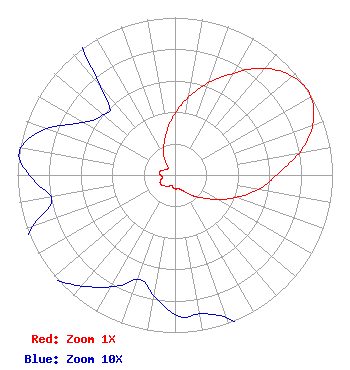 | |||||||||||||||||||||
| Azimuth | Ratio | Azimuth | Ratio | Azimuth | Ratio | Azimuth | Ratio | |||||||||||||||
| 8 | 0.480 | 18 | 0.600 | 28 | 0.720 | 38 | 0.860 | |||||||||||||||
| 48 | 0.960 | 58 | 1.000 | 68 | 0.950 | 78 | 0.830 | |||||||||||||||
| 88 | 0.670 | 98 | 0.560 | 108 | 0.440 | 118 | 0.330 | |||||||||||||||
| 128 | 0.240 | 138 | 0.180 | 148 | 0.130 | 158 | 0.100 | |||||||||||||||
| 168 | 0.090 | 178 | 0.090 | 188 | 0.080 | 198 | 0.070 | |||||||||||||||
| 208 | 0.080 | 218 | 0.090 | 228 | 0.100 | 238 | 0.110 | |||||||||||||||
| 248 | 0.100 | 258 | 0.080 | 268 | 0.090 | 278 | 0.100 | |||||||||||||||
| 288 | 0.090 | 298 | 0.070 | 308 | 0.060 | 318 | 0.065 | |||||||||||||||
| 328 | 0.130 | 338 | 0.190 | 348 | 0.270 | 358 | 0.370 | |||||||||||||||
Structure Registration Number 1037792 Structure Type: GTOWER Registered To: Maine Public Broadcasting Corp Structure Address: Mount Hope Rd Sanford, ME County Name: York County ASR Issued: 07/02/2019 Date Built: 04/24/2018 Site Elevation: 192 m (630 ft.) Structure Height: 152 m (499 ft.) Height Overall: 163.3 m (536 ft.) Overall Height AMSL: 355.3 m (1166 ft.) FAA Determination: 04/18/2018 FAA Study #: 2018-ANE-708-OE FAA Circular #: 70/7460-1L Paint & Light FAA Chapters: 3, 4, 5, 12 PRIOR STUDY 2002-ANE-811-OE 43-25-00.3 N 70-48-15.2 W (NAD 83) 43-25-00.0 N 70-48-17.0 W (Converted to NAD 27) |
63 Texas Ave. Bangor, ME 04401 Phone: 207-404-5118 Not-for-Profit | Date: 05/16/2019 Application Certifier MAINE PUBLIC BROADCASTING CORPORATION 1450 Lisbon Street Lewiston, ME 04240 Applicant GRAY FRIERSON HAERTIG 4646 S.w. Council Crest Drive Portland, OR 97239 ENGINEERING COUNSEL BARRY S. PERSH Gray Miller Persh Llp | ||||||||||||||||||||
| ||||||||||||||||||||||