
FCCInfo.com
A Service of Cavell, Mertz & Associates, Inc.
(855) FCC-INFO
|
|
|
|
|
||||||||||||||||
|
|
W300AO Channel: 300D 107.9 MHz Manahawkin, New Jersey Service: FX - A translator or application for a translator. Facility ID: 77769 Fac. Service: FX Programming Delivery Method: Unspecified Status: License Application Accepted: 11/20/2013 Application Granted: 12/17/2013 File Number: BLFT-20131120ARQ License Expires: 00/00/0000 Prefix Type: This is a license for a translator Application Type: License To Cover FCC Website Links: LMS Facility Details This Application CDBS Application Other W300AO Applications Other W300AO Applications in CDBS Including Superseded Applications Mailing Address Correspondence for W300AO Correspondence related to application BLFT-20131120ARQ Service Contour - Open Street Map or USGS Map (60 dBu) Service Contour - KML / Google Earth (60 dBu) Class: D, A Noncommercial educational operating with no more than 10W Site Location: 39-41-53.4 N 74-14-04.5 W (NAD 83) Site Location: 39-41-53.0 N 74-14-06.0 W (Converted to NAD 27) Effective Radiated Power: 0.25 kW Transmitter Output Power: 0.21 kW Antenna Center HAAT: 97.4 m Horiz.; 0 m Vert. Antenna Center AMSL: 106 m Horiz.; 66 m Vert. (348 ft. Horiz. / 217 ft. Vert.) Antenna Center HAG: 101 m Horiz.; 61 m Vert. (331 ft. Horiz. / 200 ft. Vert.) Site Elevation: 5 m. (16 ft.) Height Overall*: 110 m (361 ft.) (* As Filed In This Application, may differ from ASR Data, Below.) Directional Antenna Antenna Make/Model: None Antenna ID: 101626 Polarization:
| ||||||||||||||||||
| Antenna Data for Antenna Id: 101626 W300AO FX File: BLFT-20131120ARQ None - Service: FX | 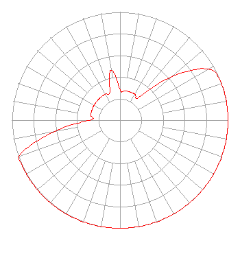 | ||||||||||||||||||
| Azimuth | Ratio | Azimuth | Ratio | Azimuth | Ratio | Azimuth | Ratio | ||||||||||||
| 0 | 0.276 | 10 | 0.276 | 20 | 0.276 | 30 | 0.276 | ||||||||||||
| 40 | 0.276 | 50 | 0.624 | 60 | 0.944 | 70 | 1.000 | ||||||||||||
| 80 | 1.000 | 90 | 1.000 | 100 | 1.000 | 110 | 1.000 | ||||||||||||
| 120 | 1.000 | 130 | 1.000 | 140 | 1.000 | 150 | 1.000 | ||||||||||||
| 160 | 1.000 | 170 | 1.000 | 180 | 1.000 | 190 | 1.000 | ||||||||||||
| 200 | 1.000 | 210 | 1.000 | 220 | 1.000 | 230 | 1.000 | ||||||||||||
| 240 | 1.000 | 250 | 1.000 | 260 | 0.624 | 270 | 0.276 | ||||||||||||
| 280 | 0.276 | 290 | 0.276 | 300 | 0.276 | 310 | 0.276 | ||||||||||||
| 320 | 0.276 | 330 | 0.276 | 340 | 0.276 | 350 | 0.469 | ||||||||||||
Structure Registration Number 1027616 [ASR Heights Differ from W300AO Application] Structure Type: GTOWER Registered To: American Towers LLC Structure Address: S Of Beach Ave Approx 1.2 Mi E Manahawkin, NJ County Name: Ocean County ASR Issued: 05/09/2017 Date Built: 11/21/2013 Site Elevation: 4 m (13 ft.) Structure Height: 109 m (358 ft.) Height Overall: 110 m (361 ft.) Overall Height AMSL: 114 m (374 ft.) FAA Determination: 05/19/2015 FAA Study #: 2015-AEA-2764-OE FAA Circular #: 70/7460-1K Paint & Light FAA Chapters: 4, 8, 12 PRIOR STUDY 2013-AEA-3688-OE 39-41-53.8 N 74-14-04.6 W (NAD 83) 39-41-53.4 N 74-14-06.1 W (Converted to NAD 27) |
3033 Riviera Drive Suite 200 Naples, FL 34103 Phone: 239-263-5000 Limited Liability Company | Date: 11/20/2013 Application Certifier JERSEY SHORE BROADCASTING CORPORATION 35 Braintree Hill Office Park Ste 300 Braintree, MA 02184 Applicant ROBERT W. GUILL Khanna & Guill, Inc. 1203 Woodlea Mill Ct. Mclean, VA 22102-2313 TECHNICAL CONSULTANT SALLY A. BUCKMAN, ESQ. Lerman Senter Pllc 2000 K Street, Nw Suite 600 Washington, DC 20006 | |||||||||||||||||