
FCCInfo.com
A Service of Cavell, Mertz & Associates, Inc.
(855) FCC-INFO
|
|
KATG from 04/17/1997 |
|  |
|
|||||||||||||||
|
|
KATG Channel: 201C1 88.1 MHz Elkhart, Texas Service: FM - A full-service FM station or application. Facility ID: 86330 Fac. Service: FM Status: License Application Accepted: 04/24/2012 Application Granted: 04/30/2012 File Number: BLED-20120424AAO License Expires: 00/00/0000 Prefix Type: This is a license for a noncommercial educational FM station Application Type: License To Cover FCC Website Links: LMS Facility Details This Application CDBS Application Other KATG Applications Other KATG Applications in CDBS Including Superseded Applications Mailing Address Correspondence for KATG Correspondence related to application BLED-20120424AAO Service Contour - Open Street Map or USGS Map (60 dBu) Service Contour - KML / Google Earth (60 dBu) Public Inspection Files Facility Type: NON-COMMERCIAL EDUC. FM Class: C1, A Zone II station; with 50kW-100kW ERP and a class contour distance 52km-72km Site Location: 32-02-41.6 N 95-40-37.9 W (NAD 83) Site Location: 32-02-41.0 N 95-40-37.0 W (Converted to NAD 27) Effective Radiated Power: 0 kW Horiz. ; 80 kW Vert. Transmitter Output Power: 6.3 kW Antenna Center HAAT: 0 m Horiz.; 166 m Vert. Antenna Center AMSL: 0 m Horiz.; 306 m Vert. Antenna Center HAG: 0 m Horiz.; 133 m Vert. Site Elevation: 173 m. (568 ft.) Height Overall*: 147 m (482 ft.) (* As Filed In This Application, may differ from ASR Data, Below.) Directional Antenna Antenna Make/Model: None Shively 6513-8-CF-D4, 8 section, vertically polarized Antenna ID: 108035 Polarization:
| ||||||||||||||||||
| Antenna Data for Antenna Id: 108035 KATG FM File: BLED-20120424AAO None - Shively 6513-8-CF-D4, 8 section, vertically polarized Service: FM | 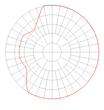 | ||||||||||||||||||
| Azimuth | Ratio | Azimuth | Ratio | Azimuth | Ratio | Azimuth | Ratio | ||||||||||||
| 0 | 1.000 | 10 | 1.000 | 20 | 1.000 | 30 | 1.000 | ||||||||||||
| 40 | 1.000 | 50 | 1.000 | 60 | 1.000 | 70 | 1.000 | ||||||||||||
| 80 | 1.000 | 90 | 1.000 | 100 | 1.000 | 110 | 1.000 | ||||||||||||
| 120 | 1.000 | 130 | 1.000 | 140 | 1.000 | 150 | 1.000 | ||||||||||||
| 160 | 1.000 | 170 | 1.000 | 180 | 1.000 | 190 | 1.000 | ||||||||||||
| 200 | 1.000 | 210 | 1.000 | 220 | 0.850 | 230 | 0.700 | ||||||||||||
| 240 | 0.650 | 250 | 0.675 | 260 | 0.700 | 270 | 0.700 | ||||||||||||
| 280 | 0.700 | 290 | 0.700 | 300 | 0.700 | 310 | 0.642 | ||||||||||||
| 320 | 0.608 | 330 | 0.677 | 340 | 0.811 | 350 | 1.000 | ||||||||||||
Structure Registration Number 1253116 Structure Type: TOWER Registered To: AMERICAN FAMILY ASSOCIATION Structure Address: 5 Miles E Us 175; On Fm2558 Frankston, TX County Name: Anderson County ASR Issued: 10/19/2009 Date Built: 08/14/2006 Site Elevation: 173 m (568 ft.) Structure Height: 147 m (482 ft.) Height Overall: 147 m (482 ft.) Overall Height AMSL: 320 m (1050 ft.) FAA Determination: 04/24/2006 FAA Study #: 2006-ASW-2216-OE FAA Circular #: 70/7460-1K Paint & Light FAA Chapters: 4, 8, 12 Removed expiration date from determination. Scenario 1./jjs/case#635066 32-02-41.6 N 95-40-37.9 W (NAD 83) 32-02-41.0 N 95-40-37.0 W (Converted to NAD 27) |
P.o. Drawer 2440 Tupelo, MS 38803 Phone: 662-844-8888 Not-for-Profit | Date: 04/24/2012 Application Certifier AMERICAN FAMILY ASSOCIATION P.o. Drawer 2440 Tupelo, MS 38801 Applicant JESSICA HUCKABY P.o. Drawer 2440 Tupelo, MS 38803 TECHNICAL CONSULTANT JESSICA HUCKABY American Family Association | |||||||||||||||||