
FCCInfo.com
A Service of Cavell, Mertz & Associates, Inc.
(855) FCC-INFO
|
|
|
|  |
|
|||||||||||||||
|
|
KBJQ Channel: 202C2 88.3 MHz Bronson, Kansas Service: FM - A full-service FM station or application. Facility ID: 88668 Fac. Service: FM Status: License Application Accepted: 05/07/2004 Application Granted: 02/02/2006 File Number: BMLED-20040507AAH License Expires: 00/00/0000 Prefix Type: This is a modification of license for a noncommercial educational FM station Application Type: Minor Modification FCC Website Links: LMS Facility Details This Application CDBS Application Other KBJQ Applications Other KBJQ Applications in CDBS Including Superseded Applications Mailing Address Correspondence for KBJQ Correspondence related to application BMLED-20040507AAH Service Contour - Open Street Map or USGS Map (60 dBu) Service Contour - KML / Google Earth (60 dBu) Public Inspection Files Facility Type: NON-COMMERCIAL EDUC. FM Class: C2, A Zone II station; with 25kW-50kW ERP and a class contour distance 39km-52km Site Location: 37-53-56.1 N 95-00-09.9 W (NAD 83) Site Location: 37-53-56.0 N 95-00-09.0 W (Converted to NAD 27) Effective Radiated Power: 36 kW Transmitter Output Power: 10.45 kW Antenna Center HAAT: 116 m (381 ft.) Antenna Center AMSL: 411 m (1348 ft.) Antenna Center HAG: 79 m (259 ft.) Calculated Site Elevation: 332 m. (1089 ft.) Height Overall*: 94 m (308 ft.) (* As Filed In This Application, may differ from ASR Data, Below.) Directional Antenna Antenna Make/Model: Shivley 6810-4R-DA Antenna ID: 15710 Polarization:
| ||||||||||||||||||
| Antenna Data for Antenna Id: 15710 KBJQ FM File: BMLED-20040507AAH Shivley - 6810-4R-DA Service: FM | 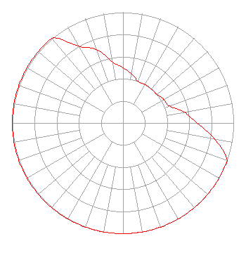 | ||||||||||||||||||
| Azimuth | Ratio | Azimuth | Ratio | Azimuth | Ratio | Azimuth | Ratio | ||||||||||||
| 0 | 0.500 | 10 | 0.450 | 20 | 0.400 | 30 | 0.400 | ||||||||||||
| 40 | 0.400 | 50 | 0.400 | 60 | 0.425 | 70 | 0.447 | ||||||||||||
| 80 | 0.562 | 90 | 0.668 | 100 | 0.841 | 110 | 1.000 | ||||||||||||
| 120 | 1.000 | 130 | 1.000 | 140 | 1.000 | 150 | 1.000 | ||||||||||||
| 160 | 1.000 | 170 | 1.000 | 180 | 1.000 | 190 | 1.000 | ||||||||||||
| 200 | 1.000 | 210 | 1.000 | 220 | 1.000 | 230 | 1.000 | ||||||||||||
| 240 | 1.000 | 250 | 1.000 | 260 | 1.000 | 270 | 1.000 | ||||||||||||
| 280 | 1.000 | 290 | 1.000 | 300 | 1.000 | 310 | 1.000 | ||||||||||||
| 320 | 1.000 | 330 | 0.800 | 340 | 0.708 | 350 | 0.562 | ||||||||||||
Structure Registration Number 1032800 Structure Type: TOWER Registered To: AMERICAN FAMILY ASSOCIATION Structure Address: 3.5 Miles East Bronson, KS County Name: Bourbon County ASR Issued: 10/19/2009 Date Built: 07/14/1989 Site Elevation: 332 m (1089 ft.) Structure Height: 94 m (308 ft.) Height Overall: 94 m (308 ft.) Overall Height AMSL: 426 m (1398 ft.) FAA Determination: 10/07/1998 FAA Study #: 98-ACE-1244-OE FAA Circular #: 70/7460-1J Paint & Light FAA Chapters: 3, 4, 5, 13 37-53-56.0 N 95-00-10.0 W (NAD 83) 37-53-55.9 N 95-00-09.1 W (Converted to NAD 27) |
Po Drawer 2440 Tupelo, MS 38803 Phone: 662-844-8888 Not-for-Profit | Date: 05/07/2004 Application Certifier AMERICAN FAMILY ASSOCIATION Great Lakes Broadcast Academy, Inc. P.o. Drawer 2440 Tupelo, MS 38801 Applicant MARSHA SHRADER Po Box 3206 Tupelo, MS 38803 TECHNICAL CONSULTANT MARSHA SHRADER American Family Association | |||||||||||||||||