
FCCInfo.com
A Service of Cavell, Mertz & Associates, Inc.
(855) FCC-INFO
|
|
W270DT from 05/14/2004 |
|
|
||||||||||||||||
|
|
W270DT Channel: 270D 101.9 MHz Durham, North Carolina Service: FX - A translator or application for a translator. Facility ID: 141386 Fac. Service: FX Programming Delivery Method: Unspecified Status: License Application Accepted: 03/19/2019 Application Granted: 04/17/2019 File Number: BLFT-20190319AAK License Expires: 00/00/0000 Prefix Type: This is a license for a translator Application Type: License To Cover FCC Website Links: LMS Facility Details This Application CDBS Application Other W270DT Applications Other W270DT Applications in CDBS Including Superseded Applications Mailing Address Correspondence for W270DT Correspondence related to application BLFT-20190319AAK Service Contour - Open Street Map or USGS Map (60 dBu) Service Contour - KML / Google Earth (60 dBu) Class: D, A Noncommercial educational operating with no more than 10W Site Location: 35-58-05.5 N 78-53-16.0 W (NAD 83) Site Location: 35-58-05.0 N 78-53-17.0 W (Converted to NAD 27) Effective Radiated Power: 0.12 kW Transmitter Output Power: 0.099 kW Antenna Center HAAT: 0 m Antenna Center AMSL: 186 m (610 ft.) Antenna Center HAG: 91 m (299 ft.) Site Elevation: 95 m. (312 ft.) Height Overall*: 103 m (338 ft.) (* As Filed In This Application, may differ from ASR Data, Below.) Directional Antenna Antenna Make/Model: None Antenna ID: 134194 Polarization:
| ||||||||||||||||||
| Antenna Data for Antenna Id: 134194 W270DT FX File: BLFT-20190319AAK None - Service: FX | 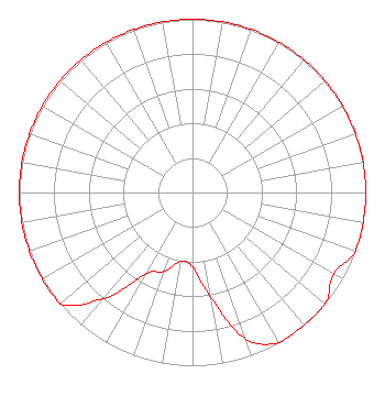 | ||||||||||||||||||
| Azimuth | Ratio | Azimuth | Ratio | Azimuth | Ratio | Azimuth | Ratio | ||||||||||||
| 0 | 1.000 | 10 | 1.000 | 20 | 1.000 | 30 | 1.000 | ||||||||||||
| 40 | 1.000 | 50 | 1.000 | 60 | 1.000 | 70 | 1.000 | ||||||||||||
| 80 | 1.000 | 90 | 1.000 | 100 | 1.000 | 110 | 1.000 | ||||||||||||
| 120 | 0.940 | 130 | 1.000 | 140 | 1.000 | 150 | 1.000 | ||||||||||||
| 160 | 0.900 | 170 | 0.615 | 180 | 0.430 | 190 | 0.405 | ||||||||||||
| 200 | 0.485 | 210 | 0.545 | 220 | 0.800 | 230 | 1.000 | ||||||||||||
| 240 | 1.000 | 250 | 1.000 | 260 | 1.000 | 270 | 1.000 | ||||||||||||
| 280 | 1.000 | 290 | 1.000 | 300 | 1.000 | 310 | 1.000 | ||||||||||||
| 320 | 1.000 | 330 | 1.000 | 340 | 1.000 | 350 | 1.000 | ||||||||||||
Structure Registration Number 1016459 [ASR Heights Differ from W270DT Application] Structure Type: GTOWER Registered To: Arohi Media LLC Structure Address: Nixon Street Just South Of Durham Durham, NC County Name: Durham County ASR Issued: 08/06/2015 Date Built: 06/15/2015 Site Elevation: 94.5 m (310 ft.) Structure Height: 101.5 m (333 ft.) Height Overall: 102.5 m (336 ft.) Overall Height AMSL: 197 m (646 ft.) FAA Determination: 02/28/1997 FAA Study #: 97-ASO-0729-OE FAA Circular #: 70/7460-1J Paint & Light FAA Chapters: 3, 4, 5, 13 35-58-05.1 N 78-53-16.2 W (NAD 83) 35-58-04.6 N 78-53-17.2 W (Converted to NAD 27) |
1324 Legendary Lane Morrisville, NC 27560 Phone: 248-219-8851 Limited Liability Company | Date: 03/19/2019 Application Certifier AROHI MEDIA LLC 110 Olympia Ln Coppell, TX 75019 Applicant TIMOTHY L. WARNER, P.E. Timothy L. Warner, Inc. Post Office Box 8045 Asheville, NC 28814-8045 TECHNICAL CONSULTANT JOHN C. TRENT, ESQ. Putbrese Hunsaker & Trent, P.c. 200 South Church Street Woodstock, VA 22664 | |||||||||||||||||