
FCCInfo.com
A Service of Cavell, Mertz & Associates, Inc.
(855) FCC-INFO
|
|
KTOP-FM from 09/01/1994 KTOP-FM from 09/10/1993 |
|  |
|
||||||||||||||||||
|
|
KTOP-FM Channel: 275C2 102.9 MHz St. Marys, Kansas Service: FM - A full-service FM station or application. Facility ID: 60034 Fac. Service: FM Status: License 73.215 Station Application Accepted: 03/26/2003 Application Granted: 06/17/2003 File Number: BLH-20030326AHX License Expires: 00/00/0000 Prefix Type: This is a license for a commercial FM station Application Type: Amendment FCC Website Links: LMS Facility Details This Application CDBS Application Other KTOP-FM Applications Other KTOP-FM Applications in CDBS Including Superseded Applications Mailing Address Correspondence for KTOP-FM Correspondence related to application BLH-20030326AHX Service Contour - Open Street Map or USGS Map (60 dBu) Service Contour - KML / Google Earth (60 dBu) Public Inspection Files Facility Type: FM STATION Class: C2, A Zone II station; with 25kW-50kW ERP and a class contour distance 39km-52km Site Location: 39-03-50.0 N 95-45-49.9 W (NAD 83) Site Location: 39-03-50.0 N 95-45-49.0 W (Converted to NAD 27) Effective Radiated Power: 30 kW Transmitter Output Power: 11.4 kW Antenna Center HAAT: 182.2 m (598 ft.) Antenna Center AMSL: 480.5 m (1576 ft.) Antenna Center HAG: 151.5 m (497 ft.) Calculated Site Elevation: 329 m. (1079 ft.) Height Overall*: 295.3 m (969 ft.) (* As Filed In This Application, may differ from ASR Data, Below.) Directional Antenna Antenna Make/Model: DIELECTRIC DCRM6ED Antenna ID: 59854 Polarization: | |||||||||||||||||||||
| Antenna Data for Antenna Id: 59854 KTOP-FM FM File: BLH-20030326AHX DIELECTRIC - DCRM6ED Service: FM | 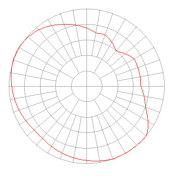 | |||||||||||||||||||||
| Azimuth | Ratio | Azimuth | Ratio | Azimuth | Ratio | Azimuth | Ratio | |||||||||||||||
| 0 | 0.750 | 10 | 0.700 | 20 | 0.700 | 30 | 0.650 | |||||||||||||||
| 40 | 0.600 | 50 | 0.650 | 60 | 0.700 | 70 | 0.700 | |||||||||||||||
| 80 | 0.700 | 90 | 0.700 | 100 | 0.750 | 110 | 0.810 | |||||||||||||||
| 120 | 0.910 | 130 | 1.000 | 140 | 1.000 | 150 | 1.000 | |||||||||||||||
| 160 | 1.000 | 170 | 0.980 | 180 | 0.960 | 190 | 0.940 | |||||||||||||||
| 200 | 0.920 | 210 | 0.900 | 220 | 0.880 | 230 | 0.880 | |||||||||||||||
| 240 | 0.900 | 250 | 0.920 | 260 | 0.940 | 270 | 0.960 | |||||||||||||||
| 280 | 0.980 | 290 | 1.000 | 300 | 1.000 | 310 | 0.980 | |||||||||||||||
| 320 | 0.950 | 330 | 0.900 | 340 | 0.850 | 350 | 0.800 | |||||||||||||||
Structure Registration Number 1032651 [ASR Heights Differ from KTOP-FM Application] Structure Type: Registered To: WASHBURN UNIVERSITY OF TOPEKA Structure Address: 301 Nw Wanamaker Road Topeka, KS County Name: Shawnee County ASR Issued: 01/02/2018 Date Built: 01/16/2004 Site Elevation: 329 m (1079 ft.) Structure Height: 265 m (869 ft.) Height Overall: 285.7 m (937 ft.) Overall Height AMSL: 614.7 m (2017 ft.) FAA Determination: 06/30/2000 FAA Study #: 00-ACE-0120-OE FAA Circular #: 70/7460-1K Paint & Light FAA Chapters: 3, 4, 5, 12 Removed final date from determination. Scenario 3./jjs/case#635066 39-03-50.0 N 95-45-50.0 W (NAD 83) 39-03-50.0 N 95-45-49.1 W (Converted to NAD 27) |
780 Johnson Ferry Road Suite 500 Atlanta, GA 30342 Phone: 404-949-0700 Limited Liability Company | Date: 03/26/2003 Application Certifier CUMULUS LICENSING CORP. Cumulus Licensing Corp. 3535 Piedmont Road Building 14, 14th Floor Atlanta, GA 30305 Applicant VIRGLE LEON STRICKLAND 12585 Old Highway 280 East Suite 102 Chelsea, AL 35043 TECHNICAL CONSULTANT MARK N. LIPP, ESQ Vinson & Elkins, Llp | ||||||||||||||||||||
| ||||||||||||||||||||||