
FCCInfo.com
A Service of Cavell, Mertz & Associates, Inc.
(855) FCC-INFO
|
|
K271BC from 06/25/2004 |
|
|
||||||||||||||||
|
|
K271BC Channel: 271D 102.1 MHz Burnet, Texas Service: FX - A translator or application for a translator. Facility ID: 139301 Fac. Service: FX Programming Delivery Method: Unspecified Status: License Application Accepted: 01/27/2006 Application Granted: 03/16/2006 File Number: BLFT-20060127AFQ License Expires: 00/00/0000 Prefix Type: This is a license for a translator Application Type: License To Cover FCC Website Links: LMS Facility Details This Application CDBS Application Other K271BC Applications Other K271BC Applications in CDBS Including Superseded Applications Mailing Address Correspondence for K271BC Correspondence related to application BLFT-20060127AFQ Service Contour - Open Street Map or USGS Map (60 dBu) Service Contour - KML / Google Earth (60 dBu) Class: D, A Noncommercial educational operating with no more than 10W Site Location: 30-45-48.7 N 98-15-04.1 W (NAD 83) Site Location: 30-45-48.0 N 98-15-03.0 W (Converted to NAD 27) Effective Radiated Power: 0.25 kW Transmitter Output Power: 0.205 kW Antenna Center HAAT: 95.8 m Horiz.; 0 m Vert. Antenna Center AMSL: 484 m (1588 ft.) Antenna Center HAG: 15 m (49 ft.) Site Elevation: 469 m. (1539 ft.) Height Overall*: 27 m (89 ft.) (* As Filed In This Application, may differ from ASR Data, Below.) Directional Antenna Antenna Make/Model: None Antenna ID: 16125 Polarization:
| ||||||||||||||||||
| Antenna Data for Antenna Id: 16125 K271BC FX File: BLFT-20060127AFQ None - Service: FX Pattern and Field Values Include a 90° Clockwise Rotation | 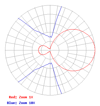 | ||||||||||||||||||
| Azimuth | Ratio | Azimuth | Ratio | Azimuth | Ratio | Azimuth | Ratio | ||||||||||||
| 0 | 0.030 | 10 | 0.045 | 20 | 0.187 | 30 | 0.388 | ||||||||||||
| 40 | 0.570 | 50 | 0.715 | 60 | 0.829 | 70 | 0.920 | ||||||||||||
| 80 | 0.979 | 90 | 1.000 | 100 | 0.979 | 110 | 0.920 | ||||||||||||
| 120 | 0.829 | 130 | 0.715 | 140 | 0.570 | 150 | 0.388 | ||||||||||||
| 160 | 0.187 | 170 | 0.045 | 180 | 0.030 | 190 | 0.032 | ||||||||||||
| 200 | 0.037 | 210 | 0.046 | 220 | 0.065 | 230 | 0.142 | ||||||||||||
| 240 | 0.202 | 250 | 0.234 | 260 | 0.250 | 270 | 0.260 | ||||||||||||
| 280 | 0.250 | 290 | 0.234 | 300 | 0.202 | 310 | 0.142 | ||||||||||||
| 320 | 0.065 | 330 | 0.046 | 340 | 0.037 | 350 | 0.032 | ||||||||||||
Structure Registration Number 1243397 Structure Type: TOWER Structure Address: 1.4 Miles West Of Hyws 29 & 281 Burnet, TX County Name: Burnet County ASR Issued: 05/13/2004 Site Elevation: 469 m (1539 ft.) Structure Height: 24 m (79 ft.) Height Overall: 27 m (89 ft.) Overall Height AMSL: 496 m (1627 ft.) FAA Determination: 03/18/2004 FAA Study #: 2003-ASW-6659-OE FAA Circular #: 70/7460-1K Paint & Light FAA Chapters: 4, 5, 12 PRIOR STUDY 1977-ASW-1343-OE 30-45-48.7 N 98-15-04.9 W (NAD 83) 30-45-48.0 N 98-15-03.8 W (Converted to NAD 27) |
4020 Menchaca Rd Austin, TX 78704 Phone: 512-829-4680 Corporation | Date: 01/27/2006 Application Certifier BIG BEND BROADCASTING 707 W. College Ave Silver City, NM 88061 Applicant JAMES S. BUMPOUS 707 W. College Ave Silver City, NM 88061 TECHNICAL CONSULTANT BIG BEND BROADCASTING Big Bend Broadcasting 707 W. College Ave Silver City, NM 88061 | |||||||||||||||||