
FCCInfo.com
A Service of Cavell, Mertz & Associates, Inc.
(855) FCC-INFO
|
|
W223BO from 10/21/1996 |
|
|
||||||||||||||||
|
|
W223BO Channel: 223D 92.5 MHz Paducah, Kentucky Service: FX - A translator or application for a translator. Facility ID: 81527 Fac. Service: FX Programming Delivery Method: Unspecified Status: License Application Accepted: 07/12/2018 Application Granted: 07/25/2018 File Number: BLFT-20180712ABC License Expires: 00/00/0000 Prefix Type: This is a license for a translator Application Type: License To Cover FCC Website Links: LMS Facility Details This Application CDBS Application Other W223BO Applications Other W223BO Applications in CDBS Including Superseded Applications Mailing Address Correspondence for W223BO Correspondence related to application BLFT-20180712ABC Service Contour - Open Street Map or USGS Map (60 dBu) Service Contour - KML / Google Earth (60 dBu) Class: D, A Noncommercial educational operating with no more than 10W Site Location: 37-05-40.2 N 88-40-20.2 W (NAD 83) Site Location: 37-05-40.0 N 88-40-20.0 W (Converted to NAD 27) Effective Radiated Power: 0.25 kW Transmitter Output Power: 0.205 kW Antenna Center HAAT: 0 m Antenna Center AMSL: 238 m (781 ft.) Antenna Center HAG: 125 m (410 ft.) Site Elevation: 113 m. (371 ft.) Height Overall*: 157 m (515 ft.) (* As Filed In This Application, may differ from ASR Data, Below.) Directional Antenna Antenna Make/Model: None Antenna ID: 129204 Polarization:
| ||||||||||||||||||
| Antenna Data for Antenna Id: 129204 W223BO FX File: BLFT-20180712ABC None - Service: FX | 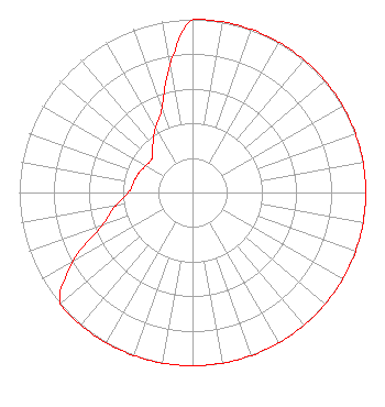 | ||||||||||||||||||
| Azimuth | Ratio | Azimuth | Ratio | Azimuth | Ratio | Azimuth | Ratio | ||||||||||||
| 0 | 1.000 | 10 | 1.000 | 20 | 1.000 | 30 | 1.000 | ||||||||||||
| 40 | 1.000 | 50 | 1.000 | 60 | 1.000 | 70 | 1.000 | ||||||||||||
| 80 | 1.000 | 90 | 1.000 | 100 | 1.000 | 110 | 1.000 | ||||||||||||
| 120 | 1.000 | 130 | 1.000 | 140 | 1.000 | 150 | 1.000 | ||||||||||||
| 160 | 1.000 | 170 | 1.000 | 180 | 1.000 | 190 | 1.000 | ||||||||||||
| 200 | 1.000 | 210 | 1.000 | 220 | 1.000 | 230 | 1.000 | ||||||||||||
| 240 | 0.795 | 250 | 0.557 | 260 | 0.451 | 270 | 0.371 | ||||||||||||
| 280 | 0.345 | 290 | 0.330 | 300 | 0.311 | 310 | 0.306 | ||||||||||||
| 320 | 0.356 | 330 | 0.429 | 340 | 0.519 | 350 | 0.747 | ||||||||||||
Structure Registration Number 1044037 [ASR Heights Differ from W223BO Application] Structure Type: GTOWER Registered To: KENTUCKY AUTHORITY FOR EDUCATIONAL TELEVISION DBA WKPD Structure Address: Coleman Rd Paducah, KY County Name: McCracken County ASR Issued: 09/13/2018 Date Built: 04/24/2019 Site Elevation: 112.5 m (369 ft.) Structure Height: 152.2 m (499 ft.) Height Overall: 164.6 m (540 ft.) Overall Height AMSL: 277.1 m (909 ft.) FAA Determination: 08/03/2018 FAA Study #: 2017-ASO-22088-OE FAA Circular #: 70/7460-1L Paint & Light FAA Chapters: 4, 8, 12 PRIOR STUDY 2003-ASO-55-OE 37-05-40.0 N 88-40-20.0 W (NAD 83) 37-05-39.8 N 88-40-19.8 W (Converted to NAD 27) |
C/o Wkms-fm 2018 University Station Murray, KY 42071 Phone: 270-809-4745 | Date: 07/12/2018 Application Certifier BOARD OF REGENTS, MURRAY STATE UNIVERSITY C/o Wkms 2018 University Station Murray, KY 42071 Applicant TIMOTHY L. WARNER, P.E. Timothy L. Warner, Inc. Post Office Box 8045 Asheville, NC 28814-8045 TECHNICAL CONSULTANT JOHN CRIGLER, ESQ. Garvey Schubert Barer 5th Floor 1000 Potomac Street, N.w. Washington, DC 20007 | |||||||||||||||||