
FCCInfo.com
A Service of Cavell, Mertz & Associates, Inc.
(855) FCC-INFO
|
|
|
|
|
||||||||||||||||
|
|
W222BY Channel: 222D 92.3 MHz Laureldale, Pennsylvania Service: FX - A translator or application for a translator. Facility ID: 138520 Fac. Service: FX Programming Delivery Method: Unspecified Status: License Application Accepted: 04/02/2014 Application Granted: 08/13/2014 File Number: BLFT-20140402AND License Expires: 00/00/0000 Prefix Type: This is a license for a translator Application Type: License To Cover FCC Website Links: LMS Facility Details This Application CDBS Application Other W222BY Applications Other W222BY Applications in CDBS Including Superseded Applications Mailing Address Correspondence for W222BY Correspondence related to application BLFT-20140402AND Service Contour - Open Street Map or USGS Map (60 dBu) Service Contour - KML / Google Earth (60 dBu) Class: D, A Noncommercial educational operating with no more than 10W Site Location: 40-19-19.3 N 75-53-33.7 W (NAD 83) Site Location: 40-19-19.0 N 75-53-35.0 W (Converted to NAD 27) Effective Radiated Power: 0 kW Horiz. ; 0.09 kW Vert. Transmitter Output Power: 0.034 kW Antenna Center HAAT: 242.4 m Horiz.; 0 m Vert. Antenna Center AMSL: 0 m Horiz.; 382 m Vert. Antenna Center HAG: 0 m Horiz.; 111 m Vert. Site Elevation: 271 m. (889 ft.) Height Overall*: 123 m (404 ft.) (* As Filed In This Application, may differ from ASR Data, Below.) Directional Antenna Antenna Make/Model: None Antenna ID: 16155 Polarization:
| ||||||||||||||||||
| Antenna Data for Antenna Id: 16155 W222BY FX File: BLFT-20140402AND None - Service: FX Pattern and Field Values Include a 300° Clockwise Rotation | 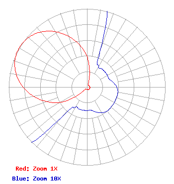 | ||||||||||||||||||
| Azimuth | Ratio | Azimuth | Ratio | Azimuth | Ratio | Azimuth | Ratio | ||||||||||||
| 0 | 0.390 | 10 | 0.190 | 20 | 0.050 | 30 | 0.030 | ||||||||||||
| 40 | 0.030 | 50 | 0.030 | 60 | 0.030 | 70 | 0.030 | ||||||||||||
| 80 | 0.034 | 90 | 0.038 | 100 | 0.040 | 110 | 0.040 | ||||||||||||
| 120 | 0.040 | 130 | 0.040 | 140 | 0.040 | 150 | 0.038 | ||||||||||||
| 160 | 0.034 | 170 | 0.030 | 180 | 0.030 | 190 | 0.030 | ||||||||||||
| 200 | 0.030 | 210 | 0.030 | 220 | 0.050 | 230 | 0.190 | ||||||||||||
| 240 | 0.390 | 250 | 0.544 | 260 | 0.690 | 270 | 0.817 | ||||||||||||
| 280 | 0.916 | 290 | 0.980 | 300 | 1.000 | 310 | 0.980 | ||||||||||||
| 320 | 0.916 | 330 | 0.817 | 340 | 0.690 | 350 | 0.544 | ||||||||||||
Structure Registration Number 1042433 Structure Type: TOWER Registered To: The Towers, LLC Structure Address: Eastern Peak Of Neversink Mountain Reading, PA County Name: Berks County ASR Issued: 03/13/2024 Date Built: 02/01/1985 Site Elevation: 271.3 m (890 ft.) Structure Height: 112.5 m (369 ft.) Height Overall: 123.1 m (404 ft.) Overall Height AMSL: 394.4 m (1294 ft.) FAA Determination: 09/30/1997 FAA Study #: 97-AEA-2506-OE FAA Circular #: 70/7460-1J Paint & Light FAA Chapters: 3, 4, 5, 13 40-19-19.0 N 75-53-34.0 W (NAD 83) 40-19-18.7 N 75-53-35.3 W (Converted to NAD 27) |
5700 West Oaks Blvd. Rocklin, CA 95765 Phone: 916-251-1600 | Date: 04/02/2014 Application Certifier CAPSTAR TX, LLC 7136 S. Yale Avenue Suite 501 Tulsa, OK 74136 Applicant MICHAEL GUIDOTTI 2625 S Memorial Dr Suite A Tulsa, OK 74129 REGIONAL ENGINEER TROY LANGHAM Clear Channel 2625 S. Memorial Drive Suite A Tulsa, OK 74129 | |||||||||||||||||
| |||||||||||||||||||