
FCCInfo.com
A Service of Cavell, Mertz & Associates, Inc.
(855) FCC-INFO
|
|
|
|
|
||||||||||||||||
|
|
W236CG Channel: 236D 95.1 MHz Bolingbrook, Illinois Service: FX - A translator or application for a translator. Facility ID: 140691 Fac. Service: FX Programming Delivery Method: Unspecified Status: License Application Accepted: 10/23/2017 Application Granted: 11/08/2017 File Number: BLFT-20171023AAW License Expires: 00/00/0000 Prefix Type: This is a license for a translator Application Type: License To Cover FCC Website Links: LMS Facility Details This Application CDBS Application Other W236CG Applications Other W236CG Applications in CDBS Including Superseded Applications Mailing Address Correspondence for W236CG Correspondence related to application BLFT-20171023AAW Service Contour - Open Street Map or USGS Map (60 dBu) Service Contour - KML / Google Earth (60 dBu) Class: D, A Noncommercial educational operating with no more than 10W Site Location: 41-55-36.1 N 87-48-24.2 W (NAD 83) Site Location: 41-55-36.0 N 87-48-24.0 W (Converted to NAD 27) Effective Radiated Power: 0.25 kW Transmitter Output Power: 0.093 kW Antenna Center HAAT: 0 m Antenna Center AMSL: 256 m (840 ft.) Antenna Center HAG: 58 m (190 ft.) Site Elevation: 198 m. (650 ft.) Height Overall*: 79 m (259 ft.) (* As Filed In This Application, may differ from ASR Data, Below.) Directional Antenna Antenna Make/Model: None Antenna ID: 129260 Polarization:
| ||||||||||||||||||
| Antenna Data for Antenna Id: 129260 W236CG FX File: BLFT-20171023AAW None - Service: FX Pattern and Field Values Include a 200° Clockwise Rotation | 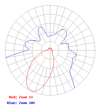 | ||||||||||||||||||
| Azimuth | Ratio | Azimuth | Ratio | Azimuth | Ratio | Azimuth | Ratio | ||||||||||||
| 0 | 0.032 | 10 | 0.034 | 20 | 0.039 | 30 | 0.053 | ||||||||||||
| 40 | 0.055 | 50 | 0.046 | 60 | 0.028 | 70 | 0.042 | ||||||||||||
| 80 | 0.042 | 90 | 0.044 | 100 | 0.059 | 110 | 0.054 | ||||||||||||
| 120 | 0.057 | 130 | 0.061 | 140 | 0.071 | 150 | 0.126 | ||||||||||||
| 160 | 0.243 | 170 | 0.391 | 180 | 0.568 | 190 | 0.797 | ||||||||||||
| 200 | 0.969 | 210 | 0.972 | 220 | 0.803 | 230 | 0.584 | ||||||||||||
| 240 | 0.428 | 250 | 0.246 | 260 | 0.106 | 270 | 0.050 | ||||||||||||
| 280 | 0.056 | 290 | 0.055 | 300 | 0.043 | 310 | 0.031 | ||||||||||||
| 320 | 0.035 | 330 | 0.052 | 340 | 0.054 | 350 | 0.031 | ||||||||||||
Structure Registration Number 1029448 Structure Type: TOWER Registered To: MARTIC, DRAGUTIN Structure Address: 2526 N Harlem Elmwood Park, IL County Name: Cook County ASR Issued: 11/03/1997 Date Built: 01/01/1947 Site Elevation: 198.1 m (650 ft.) Structure Height: 78.9 m (259 ft.) Height Overall: 78.9 m (259 ft.) Overall Height AMSL: 277.1 m (909 ft.) Paint & Light FAA Chapters: 1, 3, 11, 21 41-55-36.0 N 87-48-24.0 W (NAD 83) 41-55-35.9 N 87-48-23.8 W (Converted to NAD 27) |
C/o Shainis & Peltzman, Chartered 1850 M Street, Nw, Suite 240 Washington, DC 20036 Phone: 202-293-0011 Limited Liability Company | Date: 10/23/2017 Application Certifier WINDY CITY BROADCASTING, LLC C/o Shainis & Peltzman, Chartered 1850 M Street, Nw, Suite 240 Washington, DC 20036 Applicant AARON P. SHAINIS Shainis & Peltzman, Chartered 1850 M Street Suite 240 Washington, DC 20036 GENE WISNIEWSKI 160 Gooding Street West Suite A Twin Falls, ID 83301 CONSULTING ENGINEER | |||||||||||||||||