
FCCInfo.com
A Service of Cavell, Mertz & Associates, Inc.
(855) FCC-INFO
|
|
WWWM-FM from 03/16/2001 WWWM-FM from 10/31/1997 WWWM-FM from 05/12/1997 WWWM-FM from 02/12/1993 WWWM-FM from 03/26/1992 |
|  |
|
|||||||||||||||
|
|
WWWM-FM Channel: 289A 105.7 MHz Eden Prairie, Minnesota Service: FM - A full-service FM station or application. Facility ID: 61541 Fac. Service: FM Analog & Digital Status: License 73.215 Station Application Accepted: 05/02/2008 Application Granted: 05/15/2008 File Number: BLH-20080502ABX License Expires: 00/00/0000 Prefix Type: This is a license for a commercial FM station Application Type: License To Cover FCC Website Links: LMS Facility Details This Application CDBS Application Other WWWM-FM Applications Other WWWM-FM Applications in CDBS Including Superseded Applications Mailing Address Correspondence for WWWM-FM Correspondence related to application BLH-20080502ABX Service Contour - Open Street Map or USGS Map (60 dBu) Service Contour - KML / Google Earth (60 dBu) Public Inspection Files Facility Type: FM STATION Class: A, A Zone I; I-A; or II station; with 0.1kW-6kW ERP and a class contour distance <=28km Site Location: 44-58-33.9 N 93-16-20.8 W (NAD 83) Site Location: 44-58-34.0 N 93-16-20.0 W (Converted to NAD 27) Effective Radiated Power: 0.95 kW Transmitter Output Power: 0.91 kW Antenna Center HAAT: 254 m (833 ft.) Antenna Center AMSL: 521 m (1709 ft.) Antenna Center HAG: 261 m (856 ft.) Calculated Site Elevation: 260 m. (853 ft.) Height Overall*: 270 m (886 ft.) (* As Filed In This Application, may differ from ASR Data, Below.) Directional Antenna Antenna Make/Model: Shivley 6810-2R-SS-DA, 2 sections, 0.5 spacing Antenna ID: 82243 Polarization: | ||||||||||||||||||
| Antenna Data for Antenna Id: 82243 WWWM-FM FM File: BLH-20080502ABX Shivley - 6810-2R-SS-DA, 2 sections, 0.5 spacing Service: FM | 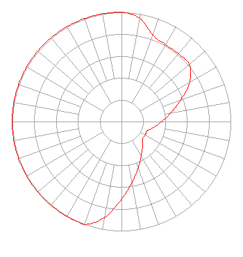 | ||||||||||||||||||
| Azimuth | Ratio | Azimuth | Ratio | Azimuth | Ratio | Azimuth | Ratio | ||||||||||||
| 0 | 1.000 | 10 | 0.960 | 20 | 0.840 | 30 | 0.810 | ||||||||||||
| 40 | 0.810 | 50 | 0.810 | 60 | 0.720 | 70 | 0.575 | ||||||||||||
| 80 | 0.460 | 90 | 0.370 | 100 | 0.300 | 110 | 0.250 | ||||||||||||
| 120 | 0.250 | 130 | 0.250 | 140 | 0.300 | 150 | 0.360 | ||||||||||||
| 160 | 0.450 | 170 | 0.565 | 180 | 0.710 | 190 | 0.890 | ||||||||||||
| 200 | 1.000 | 210 | 1.000 | 220 | 1.000 | 230 | 1.000 | ||||||||||||
| 240 | 1.000 | 250 | 1.000 | 260 | 1.000 | 270 | 1.000 | ||||||||||||
| 280 | 1.000 | 290 | 1.000 | 300 | 1.000 | 310 | 1.000 | ||||||||||||
| 320 | 1.000 | 330 | 1.000 | 340 | 1.000 | 350 | 1.000 | ||||||||||||
Structure Registration Number 1029018 Structure Type: 2BPOLE Registered To: EIGHTH STREET TOWER CORPORATION _ Please contact Broadcast Services, Inc. Structure Address: East Pole 1 - 80 S Eighth St Minneapolis, MN County Name: Hennepin County ASR Issued: 03/14/2019 Date Built: 01/01/1975 Site Elevation: 260.3 m (854 ft.) Structure Height: 236.2 m (775 ft.) Height Overall: 270.1 m (886 ft.) Overall Height AMSL: 530.4 m (1740 ft.) FAA Study #: N/A Paint & Light FAA Chapters: B, H 44-58-34.0 N 93-16-21.0 W (NAD 83) 44-58-34.1 N 93-16-20.2 W (Converted to NAD 27) |
780 Johnson Ferry Road Suite 500 Atlanta, GA 30342 Phone: 404-949-0700 Limited Liability Company | Date: 05/02/2008 Application Certifier RADIO LICENSE HOLDING III, LLC 7201 West Lake Mead Boulevard Suite 400 Las Vegas, NV 89128-8366 Applicant CHARLES M. ANDERSON 1519 Euclid Avenue Bowling Green, KY 42103 CONSULTANT RADIO LICENSE HOLDING III, LLC Radio License Holding Iii, Llc | |||||||||||||||||
| |||||||||||||||||||