
FCCInfo.com
A Service of Cavell, Mertz & Associates, Inc.
(855) FCC-INFO
|
|
KSSO from 07/14/1995 |
|  |
|
|||||||||||||||
|
|
KSSO Channel: 207A 89.3 MHz Norman, Oklahoma Service: FM - A full-service FM station or application. Facility ID: 77089 Fac. Service: FM Status: License Application Accepted: 08/14/2012 Application Granted: 08/29/2012 File Number: BLED-20120814AAW License Expires: 00/00/0000 Prefix Type: This is a license for a noncommercial educational FM station Application Type: License To Cover FCC Website Links: LMS Facility Details This Application CDBS Application Other KSSO Applications Other KSSO Applications in CDBS Including Superseded Applications Mailing Address Correspondence for KSSO Correspondence related to application BLED-20120814AAW Service Contour - Open Street Map or USGS Map (60 dBu) Service Contour - KML / Google Earth (60 dBu) Public Inspection Files Facility Type: NON-COMMERCIAL EDUC. FM Class: A, A Zone I; I-A; or II station; with 0.1kW-6kW ERP and a class contour distance <=28km Site Location: 35-13-22.2 N 97-26-22.1 W (NAD 83) Site Location: 35-13-22.0 N 97-26-21.0 W (Converted to NAD 27) Effective Radiated Power: 5.6 kW Transmitter Output Power: 2.39 kW Antenna Center HAAT: 52.8 m (173 ft.) Antenna Center AMSL: 402.3 m (1320 ft.) Antenna Center HAG: 45.7 m (150 ft.) Calculated Site Elevation: 356.6 m. (1170 ft.) Height Overall*: 48.8 m (160 ft.) (* As Filed In This Application, may differ from ASR Data, Below.) Directional Antenna Antenna Make/Model: Systems With Reliability Inc. FM3/ 3 DA Antenna ID: 108194 Polarization: | ||||||||||||||||||
| Antenna Data for Antenna Id: 108194 KSSO FM File: BLED-20120814AAW Systems With Reliability Inc. - FM3/ 3 DA Service: FM | 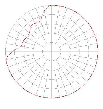 | ||||||||||||||||||
| Azimuth | Ratio | Azimuth | Ratio | Azimuth | Ratio | Azimuth | Ratio | ||||||||||||
| 0 | 1.000 | 10 | 1.000 | 20 | 1.000 | 30 | 1.000 | ||||||||||||
| 40 | 1.000 | 45 | 1.000 | 50 | 1.000 | 60 | 1.000 | ||||||||||||
| 70 | 1.000 | 80 | 1.000 | 90 | 1.000 | 100 | 1.000 | ||||||||||||
| 110 | 1.000 | 120 | 1.000 | 130 | 1.000 | 135 | 1.000 | ||||||||||||
| 140 | 1.000 | 150 | 1.000 | 160 | 1.000 | 170 | 1.000 | ||||||||||||
| 180 | 1.000 | 190 | 1.000 | 200 | 1.000 | 210 | 1.000 | ||||||||||||
| 220 | 1.000 | 225 | 1.000 | 230 | 1.000 | 240 | 1.000 | ||||||||||||
| 250 | 1.000 | 260 | 1.000 | 270 | 0.841 | 280 | 0.670 | ||||||||||||
| 290 | 0.650 | 300 | 0.620 | 310 | 0.620 | 315 | 0.660 | ||||||||||||
| 320 | 0.700 | 330 | 0.710 | 340 | 0.710 | 350 | 0.891 | ||||||||||||
Structure Registration Number 1256024 Structure Type: TOWER Registered To: Family Worship Center Church, Inc. Structure Address: N.porter Ave - Betweem E. Main & E. Gray Norman, OK County Name: Cleveland County ASR Issued: 11/08/2006 Date Built: 01/15/2007 Site Elevation: 356.6 m (1170 ft.) Structure Height: 48.8 m (160 ft.) Height Overall: 48.8 m (160 ft.) Overall Height AMSL: 405.4 m (1330 ft.) FAA Determination: 11/02/2006 FAA Study #: 2006-ASW-6989-OE Paint & Light FAA Chapters: NONE 35-13-22.2 N 97-26-22.1 W (NAD 83) 35-13-22.0 N 97-26-21.0 W (Converted to NAD 27) |
P.o. Box 262550 Baton Rouge, LA 70810 Phone: 225-768-3224 | Date: 08/14/2012 Application Certifier FAMILY WORSHIP CENTER CHURCH, INC. P.o. Box 262550 Baton Rouge, LA 70810 Applicant R. STUART GRAHAM Graham Brock, Inc. P. O. Box 24466 St. Simons Island, GA 31522-7466 TECHNICAL CONSULTANT JOHN C. TRENT, ESQUIRE Putbrese Hunsaker & Trent, P.c. | |||||||||||||||||