
FCCInfo.com
A Service of Cavell, Mertz & Associates, Inc.
(855) FCC-INFO
|
|
KAWF from 06/02/2002 |
|
|
||||||||||||||||
|
|
KAWF Channel: 203B 88.5 MHz Selma, California Service: FM - A full-service FM station or application. Facility ID: 89071 Fac. Service: FM Status: License Application Accepted: 05/18/2005 Application Granted: 09/26/2005 File Number: BMLED-20050518AAE License Expires: 00/00/0000 Prefix Type: This is a modification of license for a noncommercial educational FM station Application Type: Minor Modification FCC Website Links: LMS Facility Details This Application CDBS Application Other KAWF Applications Other KAWF Applications in CDBS Including Superseded Applications Mailing Address Correspondence for KAWF Correspondence related to application BMLED-20050518AAE Service Contour - Open Street Map or USGS Map (60 dBu) Service Contour - KML / Google Earth (60 dBu) Public Inspection Files Facility Type: NON-COMMERCIAL EDUC. FM Class: B, A Zone I or I-A station; with 25kW-50kW ERP and a class contour distance 39km-52km Site Location: 36-26-49.8 N 119-37-13.5 W (NAD 83) Site Location: 36-26-50.0 N 119-37-10.0 W (Converted to NAD 27) Effective Radiated Power: 50 kW Transmitter Output Power: 6.134 kW Antenna Center HAAT: 150 m (492 ft.) Antenna Center AMSL: 219.1 m (719 ft.) Antenna Center HAG: 138 m (453 ft.) Site Elevation: 81.1 m. (266 ft.) Height Overall*: 148.4 m (487 ft.) (* As Filed In This Application, may differ from ASR Data, Below.) Directional Antenna Antenna Make/Model: Systems With Reliability Inc. FM3/6-DA, six sections Antenna ID: 45945 Polarization:
| ||||||||||||||||||
| Antenna Data for Antenna Id: 45945 KAWF FM File: BMLED-20050518AAE Systems With Reliability Inc. - FM3/6-DA, six sections Service: FM | 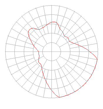 | ||||||||||||||||||
| Azimuth | Ratio | Azimuth | Ratio | Azimuth | Ratio | Azimuth | Ratio | ||||||||||||
| 0 | 0.632 | 10 | 0.632 | 20 | 0.525 | 30 | 0.485 | ||||||||||||
| 40 | 0.437 | 50 | 0.463 | 60 | 0.447 | 70 | 0.519 | ||||||||||||
| 80 | 0.654 | 90 | 0.823 | 100 | 1.000 | 110 | 1.000 | ||||||||||||
| 120 | 1.000 | 130 | 1.000 | 140 | 1.000 | 150 | 1.000 | ||||||||||||
| 160 | 1.000 | 170 | 1.000 | 180 | 0.833 | 190 | 0.661 | ||||||||||||
| 200 | 0.525 | 210 | 0.417 | 220 | 0.360 | 230 | 0.360 | ||||||||||||
| 240 | 0.317 | 250 | 0.282 | 260 | 0.282 | 270 | 0.282 | ||||||||||||
| 280 | 0.335 | 290 | 0.422 | 300 | 0.532 | 310 | 0.654 | ||||||||||||
| 320 | 0.654 | 330 | 0.550 | 340 | 0.550 | 350 | 0.583 | ||||||||||||
Structure Registration Number 1024398 Structure Type: TOWER Registered To: Educational Media Foundation Structure Address: 1772 Ninth Avenue Laton, CA County Name: Kings County ASR Issued: 04/28/2004 Date Built: 01/17/2003 Site Elevation: 81.1 m (266 ft.) Structure Height: 122.5 m (402 ft.) Height Overall: 148.4 m (487 ft.) Overall Height AMSL: 229.5 m (753 ft.) FAA Determination: 09/23/2002 FAA Study #: 2002-AWP-2648-OE FAA Circular #: 70/7460-1K Paint & Light FAA Chapters: 3, 4, 5, 12 PRIOR STUDY 1997-AWP-695-OE 36-26-50.0 N 119-37-13.0 W (NAD 83) 36-26-50.2 N 119-37-09.5 W (Converted to NAD 27) |
5700 West Oaks Blvd Rocklin, CA 95765 Phone: 916-251-1600 Not-for-Profit | Date: 05/18/2005 Application Certifier EDUCATIONAL MEDIA FOUNDATION 5700 West Oaks Blvd Rocklin, CA 95765 Applicant SAM WALLINGTON 5700 West Oaks Blvd Rocklin, CA 95765 DIRECTOR OF ENGINEERING DAVID D. OXENFORD, ESQ Pillsbury Winthrop Shaw Pittman Llp | |||||||||||||||||