
FCCInfo.com
A Service of Cavell, Mertz & Associates, Inc.
(855) FCC-INFO
|
|
WPHD from 06/29/2005 WPHD from 05/16/2005 WPHD from 12/03/1987 |
|
|
|||||||||||||||||||
|
|
WPHD Channel: 254A 98.7 MHz Corning, New York Service: FM - A full-service FM station or application. Facility ID: 19651 Fac. Service: FM Status: License 73.215 Station Application Accepted: 04/22/1999 Application Granted: 05/24/1999 File Number: BLH-19990422KF License Expires: 00/00/0000 Prefix Type: This is a license for a commercial FM station Application Type: License To Cover FCC Website Links: LMS Facility Details This Application CDBS Application Other WPHD Applications Other WPHD Applications in CDBS Including Superseded Applications Mailing Address Correspondence for WPHD Correspondence related to application BLH-19990422KF Service Contour - Open Street Map or USGS Map (60 dBu) Service Contour - KML / Google Earth (60 dBu) Public Inspection Files Facility Type: FM STATION Class: A, A Zone I; I-A; or II station; with 0.1kW-6kW ERP and a class contour distance <=28km Site Location: 42-08-31.3 N 77-04-38.9 W (NAD 83) Site Location: 42-08-31.0 N 77-04-40.0 W (Converted to NAD 27) Effective Radiated Power: 1.2 kW Antenna Center HAAT: 220 m (722 ft.) Antenna Center AMSL: 626 m (2054 ft.) Antenna Center HAG: 114 m (374 ft.) Calculated Site Elevation: 512 m. (1680 ft.) Height Overall*: 647.6 m (2125 ft.) (* As Filed In This Application, may differ from ASR Data, Below.) Directional Antenna Antenna Make/Model: Oddball; usually designed by Applicant ODD980710ID Antenna ID: 15628 Polarization: | |||||||||||||||||||||
| Antenna Data for Antenna Id: 15628 WPHD FM File: BLH-19990422KF Oddball; usually designed by Applicant - ODD980710ID Service: FM | 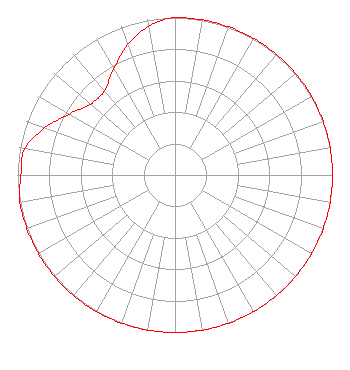 | |||||||||||||||||||||
| Azimuth | Ratio | Azimuth | Ratio | Azimuth | Ratio | Azimuth | Ratio | |||||||||||||||
| 0 | 1.000 | 10 | 1.000 | 20 | 1.000 | 30 | 1.000 | |||||||||||||||
| 40 | 1.000 | 50 | 1.000 | 60 | 1.000 | 70 | 1.000 | |||||||||||||||
| 80 | 1.000 | 90 | 1.000 | 100 | 1.000 | 110 | 1.000 | |||||||||||||||
| 120 | 1.000 | 130 | 1.000 | 140 | 1.000 | 150 | 1.000 | |||||||||||||||
| 160 | 1.000 | 170 | 1.000 | 180 | 1.000 | 190 | 1.000 | |||||||||||||||
| 200 | 1.000 | 210 | 1.000 | 220 | 1.000 | 230 | 1.000 | |||||||||||||||
| 240 | 1.000 | 250 | 1.000 | 260 | 1.000 | 270 | 0.978 | |||||||||||||||
| 280 | 0.969 | 290 | 0.879 | 300 | 0.774 | 310 | 0.700 | |||||||||||||||
| 320 | 0.698 | 330 | 0.777 | 340 | 0.879 | 350 | 0.959 | |||||||||||||||
Structure Registration Number 1045276 [ASR Heights Differ from WPHD Application] Structure Type: TOWER Registered To: T & K COMMUNICATIONS SYSTEMS INC Structure Address: Higman Hill Corning, NY County Name: Steuben County ASR Issued: 04/28/1998 Date Built: 04/01/1998 Site Elevation: 512 m (1680 ft.) Structure Height: 128 m (420 ft.) Height Overall: 135.6 m (445 ft.) Overall Height AMSL: 647.6 m (2125 ft.) FAA Determination: 01/23/1998 FAA Study #: 97-AEA-3830-OE FAA Circular #: 70/7460-1J Paint & Light FAA Chapters: 4, 8, 13 42-08-31.0 N 77-04-39.0 W (NAD 83) 42-08-30.7 N 77-04-40.1 W (Converted to NAD 27) |
115 West Main Street Frankfort, KY 40601 Phone: 502-875-1130 Limited Liability Company | Date: 04/22/1999 Application Certifier EOLIN BROADCASTING, INC. Eolin Broadcasting, Inc. P.o. Box 1047 Corning, NY 14830 Applicant | ||||||||||||||||||||
| ||||||||||||||||||||||