
FCCInfo.com
A Service of Cavell, Mertz & Associates, Inc.
(855) FCC-INFO
|
|
W240DH from 01/08/2014 |
|
|
||||||||||||||||
|
|
W240DH Channel: 240D 95.9 MHz Augusta, Maine Service: FX - A translator or application for a translator. Facility ID: 141380 Fac. Service: FX Programming Delivery Method: Unspecified Status: License (Licensed And Silent) Application Accepted: 07/14/2016 Application Granted: 08/01/2016 File Number: BLFT-20160714ACO License Expires: 00/00/0000 Prefix Type: This is a license for a translator Application Type: License To Cover FCC Website Links: LMS Facility Details This Application CDBS Application Other W240DH Applications Other W240DH Applications in CDBS Including Superseded Applications Mailing Address Correspondence for W240DH Correspondence related to application BLFT-20160714ACO Service Contour - Open Street Map or USGS Map (60 dBu) Service Contour - KML / Google Earth (60 dBu) Class: D, A Noncommercial educational operating with no more than 10W Site Location: 44-17-30.2 N 69-46-25.2 W (NAD 83) Site Location: 44-17-30.0 N 69-46-27.0 W (Converted to NAD 27) Effective Radiated Power: 0 kW Horiz. ; 0.25 kW Vert. Transmitter Output Power: 0.155 kW Antenna Center HAAT: 0 m Antenna Center AMSL: 0 m Horiz.; 120 m Vert. Antenna Center HAG: 0 m Horiz.; 51 m Vert. Site Elevation: 69 m. (226 ft.) Height Overall*: 55 m (180 ft.) (* As Filed In This Application, may differ from ASR Data, Below.) Directional Antenna Antenna Make/Model: None Antenna ID: 31326 Polarization:
| ||||||||||||||||||
| Antenna Data for Antenna Id: 31326 W240DH FX File: BLFT-20160714ACO None - Service: FX Pattern and Field Values Include a 270° Clockwise Rotation | 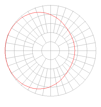 | ||||||||||||||||||
| Azimuth | Ratio | Azimuth | Ratio | Azimuth | Ratio | Azimuth | Ratio | ||||||||||||
| 0 | 0.792 | 10 | 0.735 | 20 | 0.679 | 30 | 0.630 | ||||||||||||
| 40 | 0.592 | 50 | 0.566 | 60 | 0.549 | 70 | 0.540 | ||||||||||||
| 80 | 0.535 | 90 | 0.534 | 100 | 0.535 | 110 | 0.540 | ||||||||||||
| 120 | 0.549 | 130 | 0.566 | 140 | 0.592 | 150 | 0.630 | ||||||||||||
| 160 | 0.679 | 170 | 0.735 | 180 | 0.792 | 190 | 0.845 | ||||||||||||
| 200 | 0.892 | 210 | 0.929 | 220 | 0.956 | 230 | 0.975 | ||||||||||||
| 240 | 0.987 | 250 | 0.995 | 260 | 0.999 | 270 | 1.000 | ||||||||||||
| 280 | 0.999 | 290 | 0.995 | 300 | 0.987 | 310 | 0.975 | ||||||||||||
| 320 | 0.956 | 330 | 0.929 | 340 | 0.892 | 350 | 0.845 | ||||||||||||
Structure Registration Number 1022672 Structure Type: GTOWER Registered To: Townsquare Media Augusta/Waterville, LLC Structure Address: Dr. Mann Rd. Augusta, ME County Name: Kennebec County ASR Issued: 02/25/2020 Date Built: 10/01/1993 Site Elevation: 69.5 m (228 ft.) Structure Height: 54.9 m (180 ft.) Height Overall: 54.9 m (180 ft.) Overall Height AMSL: 124.4 m (408 ft.) FAA Determination: 08/22/2016 FAA Study #: 2016-ANE-3146-OE Paint & Light FAA Chapters: NONE 44-17-31.5 N 69-46-23.8 W (NAD 83) 44-17-31.3 N 69-46-25.6 W (Converted to NAD 27) |
1 Manhattanville Road Suite 202 Purchase, NY 10577 Phone: 203-861-0900 Limited Liability Company | Date: 07/14/2016 Application Certifier TOWNSQUARE MEDIA AUGUSTA/WATERVILLE LICENSE, LLC 240 Greenwich Avenue Greenwich, CT 06830 Applicant JIM TURVAVILLE Turbo Tech Services 360 Patton Street - Po Box 144 Mobeetie, TX 79061-0144 CONSULTING ENGINEER HOWARD M. LIBERMAN Wilkinson Barker Knauer, Llp 1800 M Street, N.w. Suite 800n Washington, DC 20036 | |||||||||||||||||