
FCCInfo.com
A Service of Cavell, Mertz & Associates, Inc.
(855) FCC-INFO
|
|
WVRL from 01/03/2002 |
|
|
||||||||||||||||
|
|
WVRL Channel: 202C2 88.3 MHz Elizabeth City, North Carolina Service: FM - A full-service FM station or application. Facility ID: 86560 Fac. Service: FM Status: License Application Accepted: 02/06/2003 Application Granted: 03/17/2003 File Number: BLED-20030206ACQ License Expires: 00/00/0000 Prefix Type: This is a license for a noncommercial educational FM station Application Type: License To Cover FCC Website Links: LMS Facility Details This Application CDBS Application Other WVRL Applications Other WVRL Applications in CDBS Including Superseded Applications Mailing Address Correspondence for WVRL Correspondence related to application BLED-20030206ACQ Service Contour - Open Street Map or USGS Map (60 dBu) Service Contour - KML / Google Earth (60 dBu) Public Inspection Files Facility Type: NON-COMMERCIAL EDUC. FM Class: C2, A Zone II station; with 25kW-50kW ERP and a class contour distance 39km-52km Site Location: 36-18-40.6 N 76-17-32.8 W (NAD 83) Site Location: 36-18-40.0 N 76-17-34.0 W (Converted to NAD 27) Effective Radiated Power: 50 kW Transmitter Output Power: 8.1 kW Antenna Center HAAT: 136 m (446 ft.) Antenna Center AMSL: 136 m (446 ft.) Antenna Center HAG: 131 m (430 ft.) Site Elevation: 5 m. (16 ft.) Height Overall*: 146 m (479 ft.) (* As Filed In This Application, may differ from ASR Data, Below.) Directional Antenna Antenna Make/Model: Electronics Research Inc. LP-7C-DA Antenna ID: 15218 Polarization:
| ||||||||||||||||||
| Antenna Data for Antenna Id: 15218 WVRL FM File: BLED-20030206ACQ Electronics Research Inc. - LP-7C-DA Service: FM | 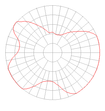 | ||||||||||||||||||
| Azimuth | Ratio | Azimuth | Ratio | Azimuth | Ratio | Azimuth | Ratio | ||||||||||||
| 0 | 0.430 | 10 | 0.392 | 20 | 0.392 | 30 | 0.440 | ||||||||||||
| 40 | 0.553 | 45 | 0.620 | 50 | 0.696 | 60 | 0.876 | ||||||||||||
| 70 | 1.000 | 80 | 1.000 | 90 | 1.000 | 100 | 1.000 | ||||||||||||
| 110 | 1.000 | 120 | 1.000 | 130 | 1.000 | 135 | 1.000 | ||||||||||||
| 140 | 1.000 | 150 | 1.000 | 160 | 0.892 | 170 | 0.709 | ||||||||||||
| 180 | 0.617 | 190 | 0.617 | 200 | 0.669 | 210 | 0.842 | ||||||||||||
| 220 | 1.000 | 225 | 1.000 | 230 | 1.000 | 240 | 1.000 | ||||||||||||
| 250 | 1.000 | 260 | 0.882 | 270 | 0.741 | 280 | 0.709 | ||||||||||||
| 290 | 0.767 | 300 | 0.956 | 310 | 1.000 | 315 | 0.923 | ||||||||||||
| 320 | 0.853 | 330 | 0.679 | 340 | 0.540 | 350 | 0.430 | ||||||||||||
Structure Registration Number 1026338 [ASR Heights Differ from WVRL Application] Structure Type: TOWER Registered To: Liberty University, Inc. Structure Address: 1500 Ft N Of Ssr 1309, 6.7 Km W Of Eliz City Elizabeth City, NC County Name: Pasquotank County ASR Issued: 01/13/2011 Date Built: 01/29/2012 Site Elevation: 4.9 m (16 ft.) Structure Height: 158 m (518 ft.) Height Overall: 158 m (518 ft.) Overall Height AMSL: 162.9 m (534 ft.) FAA Determination: 05/19/2010 FAA Study #: 2010-ASO-2090-OE FAA Circular #: 70/7460-1K Paint & Light FAA Chapters: 3, 4, 5, 12 OM&L to remain the same as prior studies = PAINT/RED LIGHTS 36-18-41.0 N 76-17-33.0 W (NAD 83) 36-18-40.4 N 76-17-34.2 W (Converted to NAD 27) |
1971 University Boulevand Lynchburg, VA 24502-2269 Phone: 434-582-3688 Private Not-for-Profit Educational Institution | Date: 02/06/2003 Application Certifier CSN INTERNATIONAL 3232 W. Macarthur Boulevard Santa Ana, CA 92704 Applicant ROBERT H. BRANCH, JR. 1460 Pine Bluff Drive Lynchburg, VA 24503 ENGINEERING MANAGER WAYNE D. JOHNSEN Wiley Rein & Fielding Llp | |||||||||||||||||