
FCCInfo.com
A Service of Cavell, Mertz & Associates, Inc.
(855) FCC-INFO
|
|
|
|
|
||||||||||||||||
|
|
K235CB Channel: 235D 94.9 MHz Chandler, Arizona Service: FX - A translator or application for a translator. Facility ID: 144641 Fac. Service: FX Programming Delivery Method: Unspecified Status: License Application Accepted: 04/23/2015 Application Granted: 05/11/2015 File Number: BLFT-20150423AAE License Expires: 00/00/0000 Prefix Type: This is a license for a translator Application Type: License To Cover FCC Website Links: LMS Facility Details This Application CDBS Application Other K235CB Applications Other K235CB Applications in CDBS Including Superseded Applications Mailing Address Correspondence for K235CB Correspondence related to application BLFT-20150423AAE Service Contour - Open Street Map or USGS Map (60 dBu) Service Contour - KML / Google Earth (60 dBu) Class: D, A Noncommercial educational operating with no more than 10W Site Location: 33-20-05.0 N 112-03-42.0 W (NAD 83) Site Location: 33-20-04.8 N 112-03-39.5 W (Converted to NAD 27) Effective Radiated Power: 0.25 kW Transmitter Output Power: 0.362 kW Antenna Center HAAT: 0 m Antenna Center AMSL: 816 m (2677 ft.) Antenna Center HAG: 31 m (102 ft.) Site Elevation: 785 m. (2575 ft.) Height Overall*: 61 m (200 ft.) (* As Filed In This Application, may differ from ASR Data, Below.) Directional Antenna Antenna Make/Model: None Antenna ID: 120802 Polarization:
| ||||||||||||||||||
| Antenna Data for Antenna Id: 120802 K235CB FX File: BLFT-20150423AAE None - Service: FX Pattern and Field Values Include a 75° Clockwise Rotation | 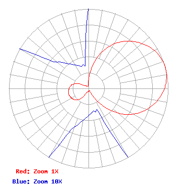 | ||||||||||||||||||
| Azimuth | Ratio | Azimuth | Ratio | Azimuth | Ratio | Azimuth | Ratio | ||||||||||||
| 5 | 0.187 | 15 | 0.388 | 25 | 0.570 | 35 | 0.715 | ||||||||||||
| 45 | 0.829 | 55 | 0.920 | 65 | 0.979 | 75 | 1.000 | ||||||||||||
| 85 | 0.979 | 95 | 0.920 | 105 | 0.829 | 115 | 0.715 | ||||||||||||
| 125 | 0.570 | 135 | 0.388 | 145 | 0.187 | 155 | 0.045 | ||||||||||||
| 165 | 0.030 | 175 | 0.032 | 185 | 0.037 | 195 | 0.046 | ||||||||||||
| 205 | 0.065 | 215 | 0.142 | 225 | 0.202 | 235 | 0.234 | ||||||||||||
| 245 | 0.250 | 255 | 0.260 | 265 | 0.250 | 275 | 0.234 | ||||||||||||
| 285 | 0.202 | 295 | 0.142 | 305 | 0.065 | 315 | 0.046 | ||||||||||||
| 325 | 0.037 | 335 | 0.032 | 345 | 0.030 | 355 | 0.045 | ||||||||||||
Structure Registration Number 1019338 Structure Type: TOWER Registered To: Vertical Bridge CC FM, LLC Structure Address: South Mountain Transmitter Site Phoenix, AZ County Name: Maricopa County ASR Issued: 11/08/2018 Date Built: 01/01/1967 Site Elevation: 784.9 m (2575 ft.) Structure Height: 61 m (200 ft.) Height Overall: 61 m (200 ft.) Overall Height AMSL: 845.9 m (2775 ft.) FAA Determination: 03/17/1997 FAA Study #: 96-AWP-3332-OE Paint & Light FAA Chapters: NONE Removed expiration date from determination. Scenario 1./jjs/case#635066 33-20-05.0 N 112-03-42.0 W (NAD 83) 33-20-04.8 N 112-03-39.5 W (Converted to NAD 27) |
4745 N 7th St. Suite #410 Phoenix, AZ 85014 Phone: 602-682-9311 Limited Liability Company | Date: 04/23/2015 Application Certifier RIVIERA BROADCASTING, LLC 4745 North 7th Street Suite 410 Phoenix, AZ 85014 Applicant ALAN D. KIRSCHNER 6029 St Peters Church Rd Myrtle Beach, SC 29588-5203 TECHNICAL CONSULTANT LEE W. SHUBERT LC Sciarrino & Shubert, Pllc 5425 Tree Line Drive Centreville, VA 20120 | |||||||||||||||||