
FCCInfo.com
A Service of Cavell, Mertz & Associates, Inc.
(855) FCC-INFO
|
|
WQSG from 07/23/1997 |
|  |
|
|||||||||||||||
|
|
WQSG Channel: 214B1 90.7 MHz Lafayette, Indiana Service: FM - A full-service FM station or application. Facility ID: 89248 Fac. Service: FM Status: License Application Accepted: 11/22/2005 Application Granted: 12/14/2005 File Number: BLED-20051122ABJ License Expires: 00/00/0000 Prefix Type: This is a license for a noncommercial educational FM station Application Type: License To Cover FCC Website Links: LMS Facility Details This Application CDBS Application Other WQSG Applications Other WQSG Applications in CDBS Including Superseded Applications Mailing Address Correspondence for WQSG Correspondence related to application BLED-20051122ABJ Service Contour - Open Street Map or USGS Map (60 dBu) Service Contour - KML / Google Earth (60 dBu) Public Inspection Files Facility Type: NON-COMMERCIAL EDUC. FM Class: B1, A Zone I or I-A station; with 6kW-25kW ERP and a class contour distance 28km-39km Site Location: 40-22-14.1 N 86-30-32.0 W (NAD 83) Site Location: 40-22-14.0 N 86-30-32.0 W (Converted to NAD 27) Effective Radiated Power: 0 kW Horiz. ; 17 kW Vert. Transmitter Output Power: 2.293 kW Antenna Center HAAT: 0 m Horiz.; 100 m Vert. Antenna Center AMSL: 0 m Horiz.; 347 m Vert. Antenna Center HAG: 0 m Horiz.; 91 m Vert. Site Elevation: 256 m. (840 ft.) Height Overall*: 100 m (328 ft.) (* As Filed In This Application, may differ from ASR Data, Below.) Directional Antenna Antenna Make/Model: Shivley 6513-5-D-4 Antenna ID: 68492 Polarization: | ||||||||||||||||||
| Antenna Data for Antenna Id: 68492 WQSG FM File: BLED-20051122ABJ Shivley - 6513-5-D-4 Service: FM | 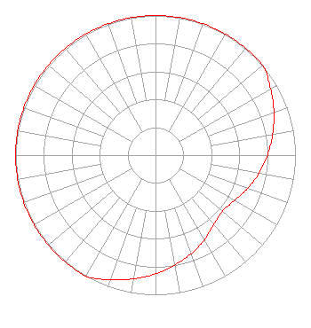 | ||||||||||||||||||
| Azimuth | Ratio | Azimuth | Ratio | Azimuth | Ratio | Azimuth | Ratio | ||||||||||||
| 0 | 1.000 | 10 | 1.000 | 20 | 1.000 | 30 | 1.000 | ||||||||||||
| 40 | 1.000 | 50 | 1.000 | 60 | 0.950 | 70 | 0.900 | ||||||||||||
| 80 | 0.850 | 90 | 0.800 | 100 | 0.750 | 110 | 0.700 | ||||||||||||
| 120 | 0.650 | 130 | 0.625 | 140 | 0.650 | 150 | 0.700 | ||||||||||||
| 160 | 0.750 | 170 | 0.800 | 180 | 0.850 | 190 | 0.900 | ||||||||||||
| 200 | 0.950 | 210 | 1.000 | 220 | 1.000 | 230 | 1.000 | ||||||||||||
| 240 | 1.000 | 250 | 1.000 | 260 | 1.000 | 270 | 1.000 | ||||||||||||
| 280 | 1.000 | 290 | 1.000 | 300 | 1.000 | 310 | 1.000 | ||||||||||||
| 320 | 1.000 | 330 | 1.000 | 340 | 1.000 | 350 | 1.000 | ||||||||||||
Structure Registration Number 1247791 Structure Type: TOWER Registered To: AMERICAN FAMILY ASSOCIATION Structure Address: N On Sr 75 To Cr 500n, R On Cr 500r To Cr Oo-e-w 7/10 Mile On Left Lafayette,, IN County Name: Clinton County ASR Issued: 10/19/2009 Date Built: 10/10/2005 Site Elevation: 255.7 m (839 ft.) Structure Height: 99.9 m (328 ft.) Height Overall: 99.9 m (328 ft.) Overall Height AMSL: 355.6 m (1167 ft.) FAA Determination: 03/23/2005 FAA Study #: 2004-AGL-7598-OE FAA Circular #: 70/7460-1K Paint & Light FAA Chapters: 4, 6, 12 Removed expiration date from determination. Scenario 1./jjs/case#635066 40-22-14.1 N 86-30-32.0 W (NAD 83) 40-22-14.0 N 86-30-32.0 W (Converted to NAD 27) |
Po Box 2440 Tupelo, MS 38801-2440 Phone: 662-844-8888 Not-for-Profit | Date: 11/22/2005 Application Certifier AMERICAN FAMILY ASSOCIATION Great Lakes Broadcast Academy, Inc. P.o. Drawer 2440 Tupelo, MS 38801 Applicant MARSHA SHRADER American Family Association P.o. Drawer 2440 Tupelo, MS 38803 TECHNICAL CONSULTANT MARSHA SHRADER American Family Association | |||||||||||||||||