
FCCInfo.com
A Service of Cavell, Mertz & Associates, Inc.
(855) FCC-INFO
|
|
|
|  |
|
|||||||||||||||
|
|
KOUA Channel: 220A 91.9 MHz Ada, Oklahoma Service: FM - A full-service FM station or application. Facility ID: 173673 Fac. Service: FM Status: License 73.215 Station Application Accepted: 01/28/2011 Application Granted: 02/11/2011 File Number: BLED-20110128AEH License Expires: 00/00/0000 Prefix Type: This is a license for a noncommercial educational FM station Application Type: License To Cover FCC Website Links: LMS Facility Details This Application CDBS Application Other KOUA Applications Other KOUA Applications in CDBS Including Superseded Applications Mailing Address Correspondence for KOUA Correspondence related to application BLED-20110128AEH Service Contour - Open Street Map or USGS Map (60 dBu) Service Contour - KML / Google Earth (60 dBu) Public Inspection Files Facility Type: NON-COMMERCIAL EDUC. FM Class: A, A Zone I; I-A; or II station; with 0.1kW-6kW ERP and a class contour distance <=28km Site Location: 34-42-31.0 N 96-44-25.0 W (NAD 83) Site Location: 34-42-30.7 N 96-44-24.0 W (Converted to NAD 27) Effective Radiated Power: 1.5 kW Transmitter Output Power: 1.526 kW Antenna Center HAAT: 81.9 m (269 ft.) Antenna Center AMSL: 400.5 m (1314 ft.) Antenna Center HAG: 56.1 m (184 ft.) Calculated Site Elevation: 344.4 m. (1130 ft.) Height Overall*: 69.4 m (228 ft.) (* As Filed In This Application, may differ from ASR Data, Below.) Directional Antenna Antenna Make/Model: Electronics Research Inc. BP-2E-DA-HW Antenna ID: 102909 Polarization:
| ||||||||||||||||||
| Antenna Data for Antenna Id: 102909 KOUA FM File: BLED-20110128AEH Electronics Research Inc. - BP-2E-DA-HW Service: FM | 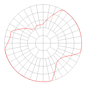 | ||||||||||||||||||
| Azimuth | Ratio | Azimuth | Ratio | Azimuth | Ratio | Azimuth | Ratio | ||||||||||||
| 0 | 0.492 | 10 | 0.619 | 20 | 0.779 | 30 | 0.981 | ||||||||||||
| 40 | 1.000 | 50 | 1.000 | 60 | 1.000 | 70 | 1.000 | ||||||||||||
| 80 | 1.000 | 90 | 1.000 | 100 | 1.000 | 103 | 1.000 | ||||||||||||
| 110 | 0.865 | 120 | 0.687 | 130 | 0.611 | 140 | 0.602 | ||||||||||||
| 150 | 0.671 | 160 | 0.844 | 168 | 1.000 | 170 | 1.000 | ||||||||||||
| 180 | 1.000 | 190 | 1.000 | 200 | 1.000 | 210 | 1.000 | ||||||||||||
| 220 | 1.000 | 230 | 1.000 | 240 | 1.000 | 250 | 1.000 | ||||||||||||
| 260 | 1.000 | 270 | 0.913 | 280 | 0.863 | 290 | 0.864 | ||||||||||||
| 300 | 0.708 | 310 | 0.589 | 320 | 0.468 | 330 | 0.426 | ||||||||||||
| 340 | 0.479 | 350 | 0.473 | ||||||||||||||||
Structure Registration Number 1011282 Structure Type: TOWER Registered To: CHICKASAW NATION DBA = CHICKASAW ENTERPRISES LTD KADA Structure Address: On Hwy 1 6 Mi Sw Ada, OK County Name: Pontotoc County ASR Issued: 03/13/1997 Date Built: 01/01/1978 Site Elevation: 344.4 m (1130 ft.) Structure Height: 69.4 m (228 ft.) Height Overall: 69.4 m (228 ft.) Overall Height AMSL: 413.8 m (1358 ft.) Paint & Light FAA Chapters: 1, 3, 11, 21 34-42-31.0 N 96-44-25.0 W (NAD 83) 34-42-30.7 N 96-44-24.0 W (Converted to NAD 27) |
860 Van Vleet Oval, Room 300 Norman, OK 73019 Phone: 405-325-3388 Government Entity | Date: 01/28/2011 Application Certifier THE UNIVERSITY OF OKLAHOMA Kgou Radio 860 Van Vleet Oval, Room 300 Norman, OK 73019-2034 Applicant KATE ENGLISH Doug Vernier Telecommunications Consulta 401 Main Street, Suite 213 Cedar Falls, IA 50613 TECHNICAL CONSULTANT BARRY S. PERSH Dow Lohnes Pllc | |||||||||||||||||