
FCCInfo.com
A Service of Cavell, Mertz & Associates, Inc.
(855) FCC-INFO
|
|
WVMP from 09/18/1995 WVMP from 10/14/1994 |
|  |
|
|||||||||||||||
|
|
WVMP Channel: 268A 101.5 MHz Vinton, Virginia Service: FM - A full-service FM station or application. Facility ID: 9047 Fac. Service: FM Status: License 73.215 Station Application Accepted: 11/06/2015 Application Granted: 11/27/2015 File Number: BLH-20151106EQX License Expires: 00/00/0000 Prefix Type: This is a license for a commercial FM station Application Type: License To Cover FCC Website Links: LMS Facility Details This Application CDBS Application Other WVMP Applications Other WVMP Applications in CDBS Including Superseded Applications Mailing Address Correspondence for WVMP Correspondence related to application BLH-20151106EQX Service Contour - Open Street Map or USGS Map (60 dBu) Service Contour - KML / Google Earth (60 dBu) Public Inspection Files Facility Type: FM STATION Class: A, A Zone I; I-A; or II station; with 0.1kW-6kW ERP and a class contour distance <=28km Site Location: 37-15-01.5 N 79-55-59.1 W (NAD 83) Site Location: 37-15-01.0 N 79-55-60.0 W (Converted to NAD 27) Effective Radiated Power: 1.2 kW Transmitter Output Power: 0.644 kW Antenna Center HAAT: 198 m (650 ft.) Antenna Center AMSL: 590.4 m (1937 ft.) Antenna Center HAG: 58.2 m (191 ft.) Calculated Site Elevation: 532.2 m. (1746 ft.) Height Overall*: 70.1 m (230 ft.) (* As Filed In This Application, may differ from ASR Data, Below.) Directional Antenna Antenna Make/Model: Shivley 6014-1-1-DA Antenna ID: 121698 Polarization:
| ||||||||||||||||||
| Antenna Data for Antenna Id: 121698 WVMP FM File: BLH-20151106EQX Shivley - 6014-1-1-DA Service: FM | 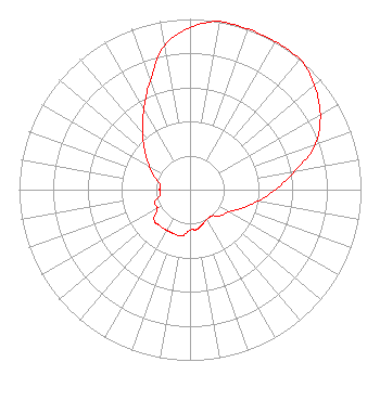 | ||||||||||||||||||
| Azimuth | Ratio | Azimuth | Ratio | Azimuth | Ratio | Azimuth | Ratio | ||||||||||||
| 0 | 0.950 | 10 | 1.000 | 20 | 1.000 | 30 | 1.000 | ||||||||||||
| 40 | 1.000 | 50 | 0.950 | 60 | 0.880 | 70 | 0.780 | ||||||||||||
| 80 | 0.625 | 90 | 0.500 | 100 | 0.400 | 110 | 0.320 | ||||||||||||
| 120 | 0.260 | 130 | 0.237 | 140 | 0.200 | 150 | 0.200 | ||||||||||||
| 160 | 0.215 | 170 | 0.236 | 180 | 0.237 | 190 | 0.275 | ||||||||||||
| 200 | 0.275 | 210 | 0.275 | 220 | 0.275 | 230 | 0.275 | ||||||||||||
| 240 | 0.220 | 250 | 0.220 | 260 | 0.178 | 270 | 0.178 | ||||||||||||
| 280 | 0.178 | 290 | 0.220 | 300 | 0.275 | 310 | 0.345 | ||||||||||||
| 320 | 0.430 | 330 | 0.541 | 340 | 0.680 | 350 | 0.855 | ||||||||||||
Structure Registration Number 1049890 Structure Type: TOWER Registered To: City of Roanoke Structure Address: Prospect Rd Mill Mountain Roanoke, VA County Name: Roanoke city ASR Issued: 01/02/2013 Date Built: 01/01/1971 Site Elevation: 532.2 m (1746 ft.) Structure Height: 61 m (200 ft.) Height Overall: 70.1 m (230 ft.) Overall Height AMSL: 602.3 m (1976 ft.) FAA Determination: 01/14/2000 FAA Study #: 99-AEA-3657-OE FAA Circular #: 70/7460-1J Paint & Light FAA Chapters: 3, 4, 5, 13 PRIOR FAA # 71-EA-414-OE 37-15-01.5 N 79-55-59.1 W (NAD 83) 37-15-01.0 N 79-55-60.0 W (Converted to NAD 27) |
1852 Banking Street Suite 9204 Greensboro, NC 27408 Phone: 336-456-8972 Limited Liability Company | Date: 11/06/2015 Application Certifier COMMUNITY MEDIA GROUP, LLC 5061 Fox Ridge Road Roanoke, VA 24018 Applicant MICHAEL D. RHODES, P.E. Cavell, Mertz & Associates, Inc. 7724 Donegan Dr. Manassas, VA 20109-2868 CONSULTING ENGINEER ERWIN G. KRASNOW Garvey Schubert Barer | |||||||||||||||||
|
| ||||||||||||||||||