
FCCInfo.com
A Service of Cavell, Mertz & Associates, Inc.
(855) FCC-INFO
|
|
|
|  |
|
|||||||||||||||
|
|
WNIE Channel: 206B1 89.1 MHz Freeport, Illinois Service: FM - A full-service FM station or application. Facility ID: 49555 Fac. Service: FM Status: License Application Accepted: 05/28/1999 Application Granted: 11/02/1999 File Number: BLED-19990528KA License Expires: 00/00/0000 Prefix Type: This is a license for a noncommercial educational FM station Application Type: License To Cover FCC Website Links: LMS Facility Details This Application CDBS Application Other WNIE Applications Other WNIE Applications in CDBS Including Superseded Applications Mailing Address Correspondence for WNIE Correspondence related to application BLED-19990528KA Service Contour - Open Street Map or USGS Map (60 dBu) Service Contour - KML / Google Earth (60 dBu) Public Inspection Files Facility Type: NON-COMMERCIAL EDUC. FM Class: B1, A Zone I or I-A station; with 6kW-25kW ERP and a class contour distance 28km-39km Site Location: 42-18-45.1 N 89-35-38.4 W (NAD 83) Site Location: 42-18-45.0 N 89-35-38.0 W (Converted to NAD 27) Effective Radiated Power: 6 kW Transmitter Output Power: 2.55 kW Antenna Center HAAT: 110 m (361 ft.) Antenna Center AMSL: 368 m (1207 ft.) Antenna Center HAG: 114 m (374 ft.) Site Elevation: 250 m. (820 ft.) Height Overall*: 137 m (449 ft.) (* As Filed In This Application, may differ from ASR Data, Below.) Directional Antenna Antenna Make/Model: DIELECTRIC DCRH3E5RD, 3 SECTIONS Antenna ID: 15360 Polarization:
| ||||||||||||||||||
| Antenna Data for Antenna Id: 15360 WNIE FM File: BLED-19990528KA DIELECTRIC - DCRH3E5RD, 3 SECTIONS Service: FM | 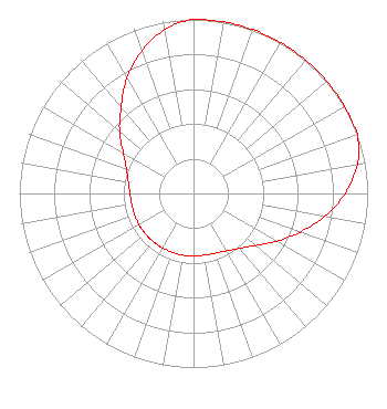 | ||||||||||||||||||
| Azimuth | Ratio | Azimuth | Ratio | Azimuth | Ratio | Azimuth | Ratio | ||||||||||||
| 0 | 1.000 | 10 | 1.000 | 20 | 1.000 | 30 | 1.000 | ||||||||||||
| 40 | 1.000 | 50 | 1.000 | 60 | 1.000 | 70 | 1.000 | ||||||||||||
| 80 | 0.955 | 90 | 0.870 | 100 | 0.765 | 110 | 0.650 | ||||||||||||
| 120 | 0.550 | 130 | 0.465 | 135 | 0.435 | 140 | 0.410 | ||||||||||||
| 150 | 0.380 | 160 | 0.365 | 170 | 0.360 | 180 | 0.360 | ||||||||||||
| 190 | 0.360 | 200 | 0.360 | 210 | 0.360 | 220 | 0.360 | ||||||||||||
| 225 | 0.360 | 230 | 0.360 | 240 | 0.360 | 250 | 0.360 | ||||||||||||
| 260 | 0.360 | 270 | 0.365 | 280 | 0.380 | 290 | 0.410 | ||||||||||||
| 300 | 0.465 | 310 | 0.550 | 315 | 0.600 | 320 | 0.650 | ||||||||||||
| 330 | 0.765 | 340 | 0.870 | 350 | 0.955 | ||||||||||||||
Structure Registration Number 1009521 Structure Type: 2TA2 Registered To: CONNOISSEUR COMMUNICATIONS OF ROCKFORD, L.P. Structure Address: Twr 2 - 834 North Tower Rd Freeport, IL County Name: Stephenson County ASR Issued: 04/22/1998 Date Built: 01/01/1981 Site Elevation: 250 m (820 ft.) Structure Height: 118 m (387 ft.) Height Overall: 137.2 m (450 ft.) Overall Height AMSL: 387.2 m (1270 ft.) FAA Determination: 10/26/1981 FAA Study #: 81-GL-889-OE Paint & Light FAA Chapters: 1, 3, 12, 21 RED LIGHTS/PAINT 42-18-46.0 N 89-35-36.0 W (NAD 83) 42-18-45.9 N 89-35-35.6 W (Converted to NAD 27) |
801 North First Street Dekalb, IL 60115 | Date: 05/28/1999 Application Certifier NORTHERN ILLINOIS UNIVERSITY Northern Illinois University/rockford Educational Broadcasting Foundation 801 North First Street Dekalb, IL 60115 Applicant | |||||||||||||||||