
FCCInfo.com
A Service of Cavell, Mertz & Associates, Inc.
(855) FCC-INFO
|
|
WHHD from 03/15/1993 WHHD from 01/13/1986 |
|  |
|
||||||||||||||||||
|
|
WHHD Channel: 252C3 98.3 MHz Clearwater, South Carolina Service: FS - A full service FM station auxiliary transmitting antenna or application. Facility ID: 24148 Fac. Service: FM Analog & Digital Status: License Application Accepted: 12/09/2005 Application Granted: 12/22/2005 File Number: BXLH-20051209AFD License Expires: 00/00/0000 Prefix Type: This is BXLH Application Type: License To Cover FCC Website Links: LMS Facility Details This Application CDBS Application Other WHHD Applications Other WHHD Applications in CDBS Including Superseded Applications Mailing Address Correspondence for WHHD Correspondence related to application BXLH-20051209AFD Service Contour - Open Street Map or USGS Map (60 dBu) Service Contour - KML / Google Earth (60 dBu) Public Inspection Files Facility Type: FM STATION Class: C3, A Zone II station; with 6kW-25kW ERP and a class contour distance 28km-39km Site Location: 33-30-44.5 N 82-04-47.4 W (NAD 83) Site Location: 33-30-44.0 N 82-04-48.0 W (Converted to NAD 27) Effective Radiated Power: 6.2 kW Transmitter Output Power: 10 kW Antenna Center HAAT: 148 m (486 ft.) Antenna Center AMSL: 242.8 m (797 ft.) Antenna Center HAG: 132.2 m (434 ft.) Calculated Site Elevation: 110.6 m. (363 ft.) Height Overall*: 136.2 m (447 ft.) (* As Filed In This Application, may differ from ASR Data, Below.) Directional Antenna Antenna Make/Model: Shivley 6810-2D/1D-IAD-DA Antenna ID: 71073 Polarization:
| |||||||||||||||||||||
| Antenna Data for Antenna Id: 71073 WHHD FS File: BXLH-20051209AFD Shivley - 6810-2D/1D-IAD-DA Service: FS | 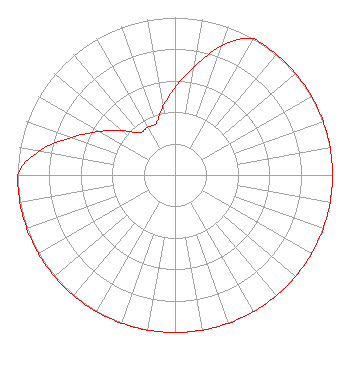 | |||||||||||||||||||||
| Azimuth | Ratio | Azimuth | Ratio | Azimuth | Ratio | Azimuth | Ratio | |||||||||||||||
| 0 | 0.554 | 10 | 0.697 | 20 | 0.877 | 30 | 1.000 | |||||||||||||||
| 40 | 1.000 | 50 | 1.000 | 60 | 1.000 | 70 | 1.000 | |||||||||||||||
| 80 | 1.000 | 90 | 1.000 | 100 | 1.000 | 110 | 1.000 | |||||||||||||||
| 120 | 1.000 | 130 | 1.000 | 140 | 1.000 | 150 | 1.000 | |||||||||||||||
| 160 | 1.000 | 170 | 1.000 | 180 | 1.000 | 190 | 1.000 | |||||||||||||||
| 200 | 1.000 | 210 | 1.000 | 220 | 1.000 | 230 | 1.000 | |||||||||||||||
| 240 | 1.000 | 250 | 1.000 | 260 | 1.000 | 270 | 1.000 | |||||||||||||||
| 280 | 0.877 | 290 | 0.697 | 300 | 0.554 | 310 | 0.440 | |||||||||||||||
| 320 | 0.350 | 330 | 0.350 | 340 | 0.350 | 350 | 0.440 | |||||||||||||||
Structure Registration Number 1022439 Structure Type: 4TA1 Registered To: GTC Uno, LLC Structure Address: Twr 1 3632 Washington Rd Martinez, GA County Name: Columbia County ASR Issued: 12/27/2023 Date Built: 09/10/2001 Site Elevation: 110.6 m (363 ft.) Structure Height: 135.3 m (444 ft.) Height Overall: 136.2 m (447 ft.) Overall Height AMSL: 246.8 m (810 ft.) FAA Determination: 08/26/1999 FAA Study #: 99-aso-3405-OE Paint & Light FAA Chapters: 1, 3, 12, 21 Removed final date from determination. Scenario 3./jjs/case#635066 33-30-44.0 N 82-04-47.0 W (NAD 83) 33-30-43.5 N 82-04-47.6 W (Converted to NAD 27) |
3033 Riviera Drive Suite 200 Naples, FL 34103 Phone: 239-263-5000 Limited Liability Company | Date: 12/09/2005 Application Certifier WGAC LICENSE, LLC 3033 Riviera Drive Suite 200 Naples, FL 34103 Applicant S. K. KHANNA Khanna & Guill, Inc. 8405-a Richmond Highway Alexandria, VA 22309-2425 CONSULTING ENGINEER DENNIS P. CORBETT, ESQ. Leventhal Senter & Lerman Pllc | ||||||||||||||||||||
|
| |||||||||||||||||||||