
FCCInfo.com
A Service of Cavell, Mertz & Associates, Inc.
(855) FCC-INFO
|
|
WKGL-FM from 06/02/2000 WKGL-FM from 08/28/1978 |
|  |
|
|||||||||||||||
|
|
WKGL-FM Channel: 244A 96.7 MHz Loves Park, Illinois Service: FM - A full-service FM station or application. Facility ID: 38638 Fac. Service: FM Status: License 73.215 Station Application Accepted: 08/23/2002 Application Granted: 11/27/2002 File Number: BLH-20020823AAB License Expires: 00/00/0000 Prefix Type: This is a license for a commercial FM station Application Type: Amendment FCC Website Links: LMS Facility Details This Application CDBS Application Other WKGL-FM Applications Other WKGL-FM Applications in CDBS Including Superseded Applications Mailing Address Correspondence for WKGL-FM Correspondence related to application BLH-20020823AAB Service Contour - Open Street Map or USGS Map (60 dBu) Service Contour - KML / Google Earth (60 dBu) Public Inspection Files History Cards for WKGL-FM Facility Type: FM STATION Class: A, A Zone I; I-A; or II station; with 0.1kW-6kW ERP and a class contour distance <=28km Site Location: 42-21-48.1 N 89-08-06.4 W (NAD 83) Site Location: 42-21-48.0 N 89-08-06.0 W (Converted to NAD 27) Effective Radiated Power: 2.2 kW Transmitter Output Power: 2.695 kW Antenna Center HAAT: 168 m (551 ft.) Antenna Center AMSL: 404 m (1325 ft.) Antenna Center HAG: 136 m (446 ft.) Site Elevation: 268 m. (879 ft.) Height Overall*: 152 m (499 ft.) (* As Filed In This Application, may differ from ASR Data, Below.) Directional Antenna Antenna Make/Model: DIELECTRIC DCR-H-2E-5RE Antenna ID: 45195 Polarization: | ||||||||||||||||||
| Antenna Data for Antenna Id: 45195 WKGL-FM FM File: BLH-20020823AAB DIELECTRIC - DCR-H-2E-5RE Service: FM | 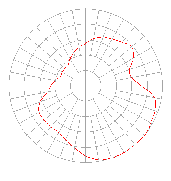 | ||||||||||||||||||
| Azimuth | Ratio | Azimuth | Ratio | Azimuth | Ratio | Azimuth | Ratio | ||||||||||||
| 0 | 0.550 | 10 | 0.620 | 20 | 0.670 | 30 | 0.700 | ||||||||||||
| 40 | 0.740 | 50 | 0.780 | 60 | 0.720 | 70 | 0.610 | ||||||||||||
| 80 | 0.610 | 90 | 0.724 | 100 | 0.910 | 110 | 0.960 | ||||||||||||
| 120 | 0.980 | 130 | 1.000 | 140 | 1.000 | 150 | 1.000 | ||||||||||||
| 160 | 1.000 | 170 | 0.980 | 180 | 0.910 | 190 | 0.820 | ||||||||||||
| 200 | 0.750 | 210 | 0.700 | 220 | 0.700 | 230 | 0.700 | ||||||||||||
| 240 | 0.700 | 250 | 0.630 | 260 | 0.500 | 270 | 0.450 | ||||||||||||
| 280 | 0.400 | 290 | 0.350 | 300 | 0.350 | 310 | 0.350 | ||||||||||||
| 320 | 0.350 | 330 | 0.400 | 340 | 0.450 | 350 | 0.500 | ||||||||||||
Structure Registration Number 1009378 Structure Type: TOWER Registered To: Tarpon Towers II, LLC Structure Address: 7241 Clikeman Rd Rockford, IL County Name: Winnebago County ASR Issued: 03/23/2020 Date Built: 03/04/1994 Site Elevation: 268 m (879 ft.) Structure Height: 150 m (492 ft.) Height Overall: 152 m (499 ft.) Overall Height AMSL: 420 m (1378 ft.) FAA Determination: 01/11/1993 FAA Study #: 92-AGL-2237-OE FAA Circular #: 70/7460-1H Paint & Light FAA Chapters: 3, 4, 5, 13 42-21-48.0 N 89-08-06.0 W (NAD 83) 42-21-47.9 N 89-08-05.6 W (Converted to NAD 27) |
1 Manhattanville Road Suite 202 Purchase, NY 10577 Phone: 203-861-0900 Limited Liability Company | Date: 08/23/2002 Application Certifier CUMULUS LICENSING CORP. Cumulus Licensing Corp. 3535 Piedmont Road Building 14, 14th Floor Atlanta, GA 30305 Applicant VIRGLE LEON STRICKLAND 12585 Old Highway 280 East Suite 102 Chelsea, AL 35043 MARK N. LIPP, ESQ. Shook, Hardy & Bacon L.l.p. | |||||||||||||||||
| |||||||||||||||||||