
FCCInfo.com
A Service of Cavell, Mertz & Associates, Inc.
(855) FCC-INFO
|
|
KLKI from 04/25/2006 KLKI from 10/23/1998 |
|
|
||||||||||||||||
|
|
KLKI Channel: 210C0 89.9 MHz Bullhead City, Arizona Service: FM - A full-service FM station or application. Facility ID: 91952 Fac. Service: FM Status: License Application Accepted: 04/28/2014 Application Granted: 05/21/2014 File Number: BLED-20140428AAP License Expires: 00/00/0000 Prefix Type: This is a license for a noncommercial educational FM station Application Type: License To Cover FCC Website Links: LMS Facility Details This Application CDBS Application Other KLKI Applications Other KLKI Applications in CDBS Including Superseded Applications Mailing Address Correspondence for KLKI Correspondence related to application BLED-20140428AAP Service Contour - Open Street Map or USGS Map (60 dBu) Service Contour - KML / Google Earth (60 dBu) Public Inspection Files Facility Type: NON-COMMERCIAL EDUC. FM Class: C0, C0 Site Location: 35-14-54.0 N 114-44-36.9 W (NAD 83) Site Location: 35-14-54.0 N 114-44-34.0 W (Converted to NAD 27) Effective Radiated Power: 0 kW Horiz. ; 18 kW Vert. Transmitter Output Power: 4.164 kW Antenna Center HAAT: 0 m Horiz.; 699.5 m Vert. Antenna Center AMSL: 0 m Horiz.; 1481 m Vert. Antenna Center HAG: 0 m Horiz.; 18 m Vert. Calculated Site Elevation: m. Height Overall*: 35 m (115 ft.) (* As Filed In This Application, may differ from ASR Data, Below.) Directional Antenna Antenna Make/Model: Propagation System Inc PSIFMV-4-HWS-DA, 4 bays, .5 wavelength spaced Antenna ID: 117929 Polarization:
| ||||||||||||||||||
| Antenna Data for Antenna Id: 117929 KLKI FM File: BLED-20140428AAP Propagation System Inc - PSIFMV-4-HWS-DA, 4 bays, .5 wavelength spaced Service: FM Pattern and Field Values Include a 10° Clockwise Rotation | 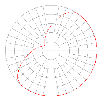 | ||||||||||||||||||
| Azimuth | Ratio | Azimuth | Ratio | Azimuth | Ratio | Azimuth | Ratio | ||||||||||||
| 0 | 0.541 | 10 | 0.680 | 20 | 0.857 | 30 | 0.978 | ||||||||||||
| 40 | 1.000 | 50 | 1.000 | 60 | 1.000 | 70 | 1.000 | ||||||||||||
| 80 | 1.000 | 90 | 1.000 | 100 | 1.000 | 110 | 1.000 | ||||||||||||
| 120 | 1.000 | 130 | 1.000 | 140 | 1.000 | 150 | 1.000 | ||||||||||||
| 160 | 1.000 | 170 | 1.000 | 180 | 1.000 | 190 | 1.000 | ||||||||||||
| 200 | 1.000 | 210 | 1.000 | 220 | 1.000 | 230 | 0.946 | ||||||||||||
| 240 | 0.800 | 250 | 0.635 | 260 | 0.505 | 270 | 0.401 | ||||||||||||
| 280 | 0.319 | 290 | 0.253 | 300 | 0.201 | 310 | 0.185 | ||||||||||||
| 320 | 0.216 | 330 | 0.271 | 340 | 0.341 | 350 | 0.430 | ||||||||||||
Structure Registration Number 1274648 [ASR Heights Differ from KLKI Application] Structure Type: TOWER Registered To: American Towers LLC Structure Address: On Sprint Mt Laughlin, NV County Name: Clark County ASR Issued: 01/05/2021 Date Built: 01/27/1999 Site Elevation: 1463 m (4800 ft.) Structure Height: 31.7 m (104 ft.) Height Overall: 34.7 m (114 ft.) Overall Height AMSL: 1497.7 m (4914 ft.) FAA Determination: 01/07/1999 FAA Study #: 98-AWP-3276-OE Paint & Light FAA Chapters: NONE 35-14-54.2 N 114-44-36.8 W (NAD 83) 35-14-54.2 N 114-44-33.9 W (Converted to NAD 27) |
5700 West Oaks Blvd. Rocklin, CA 95765 Phone: 916-251-1600 Private Not-for-Profit Educational Institution | Date: 04/28/2014 Application Certifier CALVARY CHAPEL OF TWIN FALLS, INC. Po Box 391 Twin Falls, ID 83303 Applicant LOIS MILLS P. O. Box 391 Twin Falls, ID 83303 APPLICATION TECHNITION LOIS MILLS Christian Broadcasting Of Idaho, Inc. | |||||||||||||||||