
FCCInfo.com
A Service of Cavell, Mertz & Associates, Inc.
(855) FCC-INFO
|
|
WCSJ-FM from 02/02/1998 WCSJ-FM from 05/22/1992 WCSJ-FM from 04/09/1992 |
|
|
||||||||||||||||
|
|
WCSJ-FM Channel: 276A 103.1 MHz Morris, Illinois Service: FM - A full-service FM station or application. Facility ID: 17038 Fac. Service: FM Status: License 73.215 Station Application Accepted: 02/05/2014 Application Granted: 02/11/2014 File Number: BMLH-20140205ACR License Expires: 00/00/0000 Prefix Type: This is a modification of a license for a commecial FM station Application Type: Minor Modification FCC Website Links: LMS Facility Details This Application CDBS Application Other WCSJ-FM Applications Other WCSJ-FM Applications in CDBS Including Superseded Applications Mailing Address Correspondence for WCSJ-FM Correspondence related to application BMLH-20140205ACR Service Contour - Open Street Map or USGS Map (60 dBu) Service Contour - KML / Google Earth (60 dBu) Public Inspection Files Facility Type: FM STATION Class: A, A Zone I; I-A; or II station; with 0.1kW-6kW ERP and a class contour distance <=28km Site Location: 41-17-35.1 N 88-20-04.2 W (NAD 83) Site Location: 41-17-35.0 N 88-20-04.0 W (Converted to NAD 27) Effective Radiated Power: 6 kW Transmitter Output Power: 3.15 kW Antenna Center HAAT: 100 m (328 ft.) Antenna Center AMSL: 266 m (873 ft.) Antenna Center HAG: 98 m (322 ft.) Calculated Site Elevation: 168 m. (551 ft.) Height Overall*: 102 m (335 ft.) (* As Filed In This Application, may differ from ASR Data, Below.) Directional Antenna Antenna Make/Model: Electronics Research Inc. LP-4E-DA-HW Antenna ID: 15694 Polarization:
| ||||||||||||||||||
| Antenna Data for Antenna Id: 15694 WCSJ-FM FM File: BMLH-20140205ACR Electronics Research Inc. - LP-4E-DA-HW Service: FM | 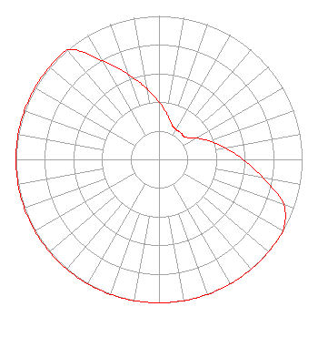 | ||||||||||||||||||
| Azimuth | Ratio | Azimuth | Ratio | Azimuth | Ratio | Azimuth | Ratio | ||||||||||||
| 0 | 0.400 | 10 | 0.320 | 20 | 0.260 | 30 | 0.240 | ||||||||||||
| 40 | 0.240 | 50 | 0.240 | 60 | 0.300 | 70 | 0.375 | ||||||||||||
| 80 | 0.471 | 90 | 0.588 | 100 | 0.739 | 110 | 0.928 | ||||||||||||
| 120 | 1.000 | 130 | 1.000 | 140 | 1.000 | 150 | 1.000 | ||||||||||||
| 160 | 1.000 | 170 | 1.000 | 180 | 1.000 | 190 | 1.000 | ||||||||||||
| 200 | 1.000 | 210 | 1.000 | 220 | 1.000 | 230 | 1.000 | ||||||||||||
| 240 | 1.000 | 250 | 1.000 | 260 | 1.000 | 270 | 1.000 | ||||||||||||
| 280 | 1.000 | 290 | 1.000 | 300 | 1.000 | 310 | 1.000 | ||||||||||||
| 320 | 1.000 | 330 | 0.795 | 340 | 0.632 | 350 | 0.503 | ||||||||||||
Structure Registration Number 1009089 Structure Type: TOWER Registered To: Grundy County Broadcasters, Inc., Structure Address: 1 Mi E Of Gorman Rd On Mc Cardle Rd Coal City, IL County Name: Grundy County ASR Issued: 11/06/2003 Date Built: 01/01/1991 Site Elevation: 168 m (551 ft.) Structure Height: 101 m (331 ft.) Height Overall: 101.8 m (334 ft.) Overall Height AMSL: 269.8 m (885 ft.) FAA Determination: 03/27/1991 FAA Study #: 91-AGL-0485-OE FAA Circular #: 70/7460-1G Paint & Light FAA Chapters: 3, 4, 5, 9 41-17-35.0 N 88-20-04.0 W (NAD 83) 41-17-34.9 N 88-20-03.8 W (Converted to NAD 27) |
Attn: Larry Nelson One Broadcast Center Plano, IL 60545-2100 Phone: 000-000-0000 | Date: 02/05/2014 Application Certifier GRUNDY COUNTY BROADCASTERS, INC. Attn: Larry Nelson One Broadcast Center Plano, IL 60545 Applicant LARRY NELSON One Broadcast Center Plano, IL 60545 PRESIDENT JOHN NEELY, ESQ. Miller And Neely, P.c. | |||||||||||||||||
| |||||||||||||||||||