
FCCInfo.com
A Service of Cavell, Mertz & Associates, Inc.
(855) FCC-INFO
|
|
|
|
|
||||||||||||||||
|
|
KBMQ Channel: 204C2 88.7 MHz Monroe, Louisiana Service: FM - A full-service FM station or application. Facility ID: 22172 Fac. Service: FM Status: License Application Accepted: 07/29/2005 Application Granted: 08/15/2005 File Number: BLED-20050729DMI License Expires: 00/00/0000 Prefix Type: This is a license for a noncommercial educational FM station Application Type: License To Cover FCC Website Links: LMS Facility Details This Application CDBS Application Other KBMQ Applications Other KBMQ Applications in CDBS Including Superseded Applications Mailing Address Correspondence for KBMQ Correspondence related to application BLED-20050729DMI Service Contour - Open Street Map or USGS Map (60 dBu) Service Contour - KML / Google Earth (60 dBu) Public Inspection Files Facility Type: NON-COMMERCIAL EDUC. FM Class: C2, A Zone II station; with 25kW-50kW ERP and a class contour distance 39km-52km Site Location: 32-24-15.5 N 92-02-07.5 W (NAD 83) Site Location: 32-24-15.0 N 92-02-07.0 W (Converted to NAD 27) Effective Radiated Power: 25 kW Horiz. ; 24.5 kW Vert. Transmitter Output Power: 8.46 kW Antenna Center HAAT: 139.6 m (458 ft.) Antenna Center AMSL: 157 m (515 ft.) Antenna Center HAG: 138.7 m (455 ft.) Site Elevation: 18.3 m. (60 ft.) Height Overall*: 146.3 m (480 ft.) (* As Filed In This Application, may differ from ASR Data, Below.) Directional Antenna Antenna Make/Model: Shivley 6810-4-DA Antenna ID: 69155 Polarization: | ||||||||||||||||||
| Antenna Data for Antenna Id: 69155 KBMQ FM File: BLED-20050729DMI Shivley - 6810-4-DA Service: FM | 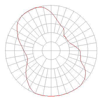 | ||||||||||||||||||
| Azimuth | Ratio | Azimuth | Ratio | Azimuth | Ratio | Azimuth | Ratio | ||||||||||||
| 0 | 0.840 | 10 | 0.695 | 20 | 0.600 | 30 | 0.550 | ||||||||||||
| 40 | 0.440 | 45 | 0.433 | 50 | 0.425 | 60 | 0.425 | ||||||||||||
| 70 | 0.455 | 80 | 0.535 | 90 | 0.625 | 100 | 0.650 | ||||||||||||
| 110 | 0.695 | 120 | 0.860 | 130 | 0.955 | 135 | 0.978 | ||||||||||||
| 140 | 1.000 | 150 | 1.000 | 160 | 1.000 | 170 | 1.000 | ||||||||||||
| 180 | 1.000 | 190 | 1.000 | 200 | 1.000 | 210 | 0.925 | ||||||||||||
| 220 | 0.820 | 225 | 0.765 | 230 | 0.710 | 240 | 0.605 | ||||||||||||
| 250 | 0.545 | 260 | 0.550 | 270 | 0.595 | 280 | 0.660 | ||||||||||||
| 290 | 0.755 | 300 | 0.850 | 310 | 0.945 | 315 | 0.970 | ||||||||||||
| 320 | 0.995 | 330 | 1.000 | 340 | 1.000 | 350 | 0.960 | ||||||||||||
Structure Registration Number 1245273 Structure Type: TOWER Registered To: Media Ministries, Inc. Structure Address: 1230 Miller Road Monroe, LA County Name: Ouachita Parish ASR Issued: 09/16/2004 Date Built: 09/30/2004 Site Elevation: 18.3 m (60 ft.) Structure Height: 145.4 m (477 ft.) Height Overall: 146.3 m (480 ft.) Overall Height AMSL: 164.6 m (540 ft.) FAA Determination: 08/23/2004 FAA Study #: 2004-ASW-3927-OE FAA Circular #: 70/7460-1K Paint & Light FAA Chapters: 3, 4, 5, 12 Removed expiration date from determination. Scenario 1./jjs/case#635066 32-24-15.2 N 92-02-07.4 W (NAD 83) 32-24-14.7 N 92-02-06.9 W (Converted to NAD 27) |
P.o. Box 3265 Monroe, LA 71210 Phone: 318-387-1230 Corporation | Date: 07/29/2005 Application Certifier MEDIA MINISTRIES, INC. 1700 Parkview Drive Monroe, LA 71202 Applicant R. STUART GRAHAM Graham Brock, Inc. P.o. Box 24466 St. Simons Island, GA 31522-7466 TECHNICAL CONSULTANT ELISE M. STUBBE Hardy, Carey, Chautin & Balkin, L.l.p. | |||||||||||||||||
| |||||||||||||||||||