
FCCInfo.com
A Service of Cavell, Mertz & Associates, Inc.
(855) FCC-INFO
|
|
|
|  |
|
|||||||||||||||
|
|
WAEF Channel: 212C2 90.3 MHz Cordele, Georgia Service: FM - A full-service FM station or application. Facility ID: 88121 Fac. Service: FM Status: License Application Accepted: 06/07/2001 Application Granted: 07/26/2001 File Number: BLED-20010607AAH License Expires: 00/00/0000 Prefix Type: This is a license for a noncommercial educational FM station Application Type: Amendment FCC Website Links: LMS Facility Details This Application CDBS Application Other WAEF Applications Other WAEF Applications in CDBS Including Superseded Applications Mailing Address Correspondence for WAEF Correspondence related to application BLED-20010607AAH Service Contour - Open Street Map or USGS Map (60 dBu) Service Contour - KML / Google Earth (60 dBu) Public Inspection Files Facility Type: NON-COMMERCIAL EDUC. FM Class: C2, A Zone II station; with 25kW-50kW ERP and a class contour distance 39km-52km Site Location: 31-38-22.6 N 83-44-57.6 W (NAD 83) Site Location: 31-38-22.0 N 83-44-58.0 W (Converted to NAD 27) Effective Radiated Power: 0 kW Horiz. ; 11 kW Vert. Transmitter Output Power: 0.88 kW Antenna Center HAAT: 0 m Horiz.; 154 m Vert. Antenna Center AMSL: 0 m Horiz.; 263 m Vert. Antenna Center HAG: 0 m Horiz.; 141 m Vert. Site Elevation: 122 m. (400 ft.) Height Overall*: 189 m (620 ft.) (* As Filed In This Application, may differ from ASR Data, Below.) Directional Antenna Antenna Make/Model: Shivley 6513-7-DA Antenna ID: 37996 Polarization:
| ||||||||||||||||||
| Antenna Data for Antenna Id: 37996 WAEF FM File: BLED-20010607AAH Shivley - 6513-7-DA Service: FM | 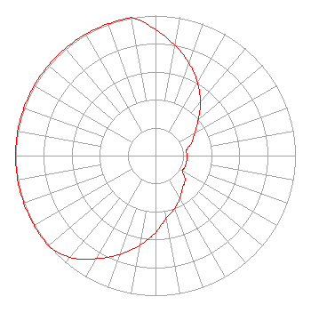 | ||||||||||||||||||
| Azimuth | Ratio | Azimuth | Ratio | Azimuth | Ratio | Azimuth | Ratio | ||||||||||||
| 0 | 0.900 | 10 | 0.800 | 20 | 0.700 | 30 | 0.600 | ||||||||||||
| 40 | 0.500 | 50 | 0.400 | 60 | 0.325 | 70 | 0.275 | ||||||||||||
| 80 | 0.225 | 90 | 0.225 | 100 | 0.225 | 110 | 0.225 | ||||||||||||
| 120 | 0.225 | 130 | 0.275 | 140 | 0.300 | 150 | 0.350 | ||||||||||||
| 160 | 0.400 | 170 | 0.450 | 180 | 0.550 | 190 | 0.650 | ||||||||||||
| 200 | 0.750 | 210 | 0.850 | 220 | 0.950 | 230 | 1.000 | ||||||||||||
| 240 | 1.000 | 250 | 1.000 | 260 | 1.000 | 270 | 1.000 | ||||||||||||
| 280 | 1.000 | 290 | 1.000 | 300 | 1.000 | 310 | 1.000 | ||||||||||||
| 320 | 1.000 | 330 | 1.000 | 340 | 1.000 | 350 | 1.000 | ||||||||||||
Structure Registration Number 1221051 Structure Type: TOWER Registered To: AMERICAN FAMILY ASSOCIATION Structure Address: Hill Road Ashburn, GA County Name: Turner County ASR Issued: 10/23/2009 Date Built: 06/07/2001 Site Elevation: 122 m (400 ft.) Structure Height: 189 m (620 ft.) Height Overall: 189 m (620 ft.) Overall Height AMSL: 311 m (1020 ft.) FAA Determination: 11/14/2000 FAA Study #: 00-ASO-6105-OE FAA Circular #: 70/7460-1K Paint & Light FAA Chapters: 4, 7, 12 Removed expiration and final dates from determination. Scenario 2./jjs/case#635066 31-38-22.6 N 83-44-57.6 W (NAD 83) 31-38-22.0 N 83-44-58.0 W (Converted to NAD 27) |
Po Box 2440 Tupelo, MS 38801-2440 Phone: 662-844-8888 Not-for-Profit | Date: 06/07/2001 Application Certifier AMERICAN FAMILY ASSOCIATION P.o. Drawer 2440 Tupelo, MS 38801 Applicant TECHNICAL CONSULTANT | |||||||||||||||||