
FCCInfo.com
A Service of Cavell, Mertz & Associates, Inc.
(855) FCC-INFO
|
|
WMGU from 09/20/2005 WMGU from 11/10/1995 WMGU from 10/19/1992 |
|  |
|
|||||||||||||||
|
|
WMGU Channel: 295C2 106.9 MHz Southern Pines, North Carolina Service: FM - A full-service FM station or application. Facility ID: 46948 Fac. Service: FM Status: License 73.215 Station Application Accepted: 03/30/2009 Application Granted: 04/09/2009 File Number: BLH-20090330AIO License Expires: 00/00/0000 Prefix Type: This is a license for a commercial FM station Application Type: License To Cover FCC Website Links: LMS Facility Details This Application CDBS Application Other WMGU Applications Other WMGU Applications in CDBS Including Superseded Applications Mailing Address Correspondence for WMGU Correspondence related to application BLH-20090330AIO Service Contour - Open Street Map or USGS Map (60 dBu) Service Contour - KML / Google Earth (60 dBu) Public Inspection Files History Cards for WMGU Facility Type: FM STATION Class: C2, A Zone II station; with 25kW-50kW ERP and a class contour distance 39km-52km Site Location: 34-59-53.6 N 79-15-46.1 W (NAD 83) Site Location: 34-59-53.0 N 79-15-47.0 W (Converted to NAD 27) Effective Radiated Power: 50 kW Transmitter Output Power: 17.5 kW Antenna Center HAAT: 142.8 m (469 ft.) Antenna Center AMSL: 226.2 m (742 ft.) Antenna Center HAG: 144.2 m (473 ft.) Calculated Site Elevation: 82 m. (269 ft.) Height Overall*: 152.1 m (499 ft.) (* As Filed In This Application, may differ from ASR Data, Below.) Directional Antenna Antenna Make/Model: DIELECTRIC DCRM-4EP, four sections Antenna ID: 65010 Polarization: | ||||||||||||||||||
| Antenna Data for Antenna Id: 65010 WMGU FM File: BLH-20090330AIO DIELECTRIC - DCRM-4EP, four sections Service: FM | 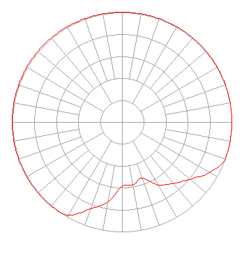 | ||||||||||||||||||
| Azimuth | Ratio | Azimuth | Ratio | Azimuth | Ratio | Azimuth | Ratio | ||||||||||||
| 0 | 1.000 | 10 | 1.000 | 20 | 1.000 | 30 | 1.000 | ||||||||||||
| 40 | 1.000 | 50 | 1.000 | 60 | 1.000 | 70 | 1.000 | ||||||||||||
| 80 | 1.000 | 90 | 1.000 | 100 | 1.000 | 110 | 1.000 | ||||||||||||
| 120 | 0.920 | 130 | 0.810 | 140 | 0.730 | 150 | 0.660 | ||||||||||||
| 160 | 0.544 | 170 | 0.580 | 180 | 0.588 | 190 | 0.739 | ||||||||||||
| 200 | 0.843 | 210 | 0.978 | 220 | 1.000 | 230 | 1.000 | ||||||||||||
| 240 | 1.000 | 250 | 1.000 | 260 | 1.000 | 270 | 1.000 | ||||||||||||
| 280 | 1.000 | 290 | 1.000 | 300 | 1.000 | 310 | 1.000 | ||||||||||||
| 320 | 1.000 | 330 | 1.000 | 340 | 1.000 | 350 | 1.000 | ||||||||||||
Structure Registration Number 1241032 Structure Type: TOWER Registered To: VB Nimbus, LLC Structure Address: At The End Of Ranch Road Raeford, NC County Name: Hoke County ASR Issued: 10/13/2020 Date Built: 01/22/2009 Site Elevation: 82 m (269 ft.) Structure Height: 151.2 m (496 ft.) Height Overall: 152.1 m (499 ft.) Overall Height AMSL: 234.1 m (768 ft.) FAA Determination: 01/22/2009 FAA Study #: 2009-ASO-298-OE FAA Circular #: 70/7460-1K Paint & Light FAA Chapters: 4, 8, 12 PRIOR STUDY 2003-ASO-5282-OE 34-59-53.5 N 79-15-46.1 W (NAD 83) 34-59-52.9 N 79-15-47.0 W (Converted to NAD 27) |
780 Johnson Ferry Road Suite 500 Atlanta, GA 30342 Phone: 404-949-0700 Limited Liability Company | Date: 03/30/2009 Application Certifier CUMULUS LICENSING LLC 3280 Peachtree Road Nw Suite 2300 Atlanta, GA 30305 Applicant JEFFERSON G. BROCK Graham Brock, Inc. P. O. Box 24466 St. Simons Island, GA 31522-7466 TECHNICAL CONSULTANT MARK N. LIPP, ESQ. Wiley Rein Llp | |||||||||||||||||
| |||||||||||||||||||