
FCCInfo.com
A Service of Cavell, Mertz & Associates, Inc.
(855) FCC-INFO
|
|
W284CS from 11/10/2014 W284CS from 01/13/2014 |
|
|
||||||||||||||||
|
|
W284CS Channel: 284D 104.7 MHz Miami, Florida Service: FX - A translator or application for a translator. Facility ID: 158312 Fac. Service: FX Programming Delivery Method: Unspecified Status: License Application Accepted: 09/23/2015 Application Granted: 10/14/2015 File Number: BLFT-20150923ALK License Expires: 02/01/2028 Prefix Type: This is a license for a translator Application Type: License To Cover FCC Website Links: LMS Facility Details This Application CDBS Application Other W284CS Applications Other W284CS Applications in CDBS Including Superseded Applications Mailing Address Correspondence for W284CS Correspondence related to application BLFT-20150923ALK Service Contour - Open Street Map or USGS Map (60 dBu) Service Contour - KML / Google Earth (60 dBu) Class: D, A Noncommercial educational operating with no more than 10W Site Location: 25-58-08.3 N 80-13-19.2 W (NAD 83) Site Location: 25-58-07.0 N 80-13-20.0 W (Converted to NAD 27) Effective Radiated Power: 0.099 kW Transmitter Output Power: 0.11 kW Antenna Center HAAT: 0 m Antenna Center AMSL: 230 m (755 ft.) Antenna Center HAG: 228 m (748 ft.) Site Elevation: 2 m. (7 ft.) Height Overall*: 317 m (1040 ft.) (* As Filed In This Application, may differ from ASR Data, Below.) Directional Antenna Antenna Make/Model: Scala CA2 COMPOSITE Antenna ID: 121963 Polarization: H
| ||||||||||||||||||
| Antenna Data for Antenna Id: 121963 W284CS FX File: BLFT-20150923ALK Scala - CA2 COMPOSITE Service: FX | 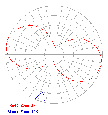 | ||||||||||||||||||
| Azimuth | Ratio | Azimuth | Ratio | Azimuth | Ratio | Azimuth | Ratio | ||||||||||||
| 0 | 0.205 | 10 | 0.144 | 20 | 0.166 | 30 | 0.244 | ||||||||||||
| 40 | 0.330 | 50 | 0.468 | 60 | 0.634 | 70 | 0.762 | ||||||||||||
| 80 | 0.877 | 90 | 0.952 | 100 | 0.985 | 110 | 0.976 | ||||||||||||
| 120 | 0.932 | 130 | 0.847 | 140 | 0.711 | 150 | 0.561 | ||||||||||||
| 160 | 0.400 | 170 | 0.276 | 180 | 0.189 | 190 | 0.104 | ||||||||||||
| 200 | 0.086 | 210 | 0.168 | 220 | 0.272 | 230 | 0.435 | ||||||||||||
| 240 | 0.592 | 250 | 0.733 | 260 | 0.863 | 270 | 0.948 | ||||||||||||
| 280 | 0.993 | 290 | 0.997 | 300 | 0.959 | 310 | 0.867 | ||||||||||||
| 320 | 0.766 | 330 | 0.642 | 340 | 0.482 | 350 | 0.313 | ||||||||||||
Structure Registration Number 1026553 [ASR Heights Differ from W284CS Application] Structure Type: GTOWER Registered To: American Towers LLC Structure Address: 1255 Nw 210th Street (282698) Miami, FL County Name: Miami-Dade County ASR Issued: 10/12/2023 Date Built: 01/01/1990 Site Elevation: 1.5 m (5 ft.) Structure Height: 289.9 m (951 ft.) Height Overall: 318.2 m (1044 ft.) Overall Height AMSL: 319.7 m (1049 ft.) FAA Determination: 04/21/2023 FAA Study #: 2022-ASO-14780-OE FAA Circular #: 70/7460-1G Paint & Light FAA Chapters: 4, 6, 9 PRIOR STUDY 2021-ASO-25139-OE 25-58-08.3 N 80-13-19.2 W (NAD 83) 25-58-07.0 N 80-13-20.0 W (Converted to NAD 27) |
7136 S. Yale Avenue Suite 501 Tulsa, OK 74136 Phone: 918-664-4581 Limited Liability Company | Date: 09/23/2015 Application Certifier CHARLES E. CRAWFORD 2215 Cedar Springs Rd #1605 Dallas, TX 75201 Applicant WESTON MCCARRON 2849 Sugar Tree Lane Maryland Heights, MO 63043 TECHNICAL CONSULTANT CHARLES E. CRAWFORD Charles E. Crawford 2215 Cedar Springs Rd #1605 Dallas, TX 75201 | |||||||||||||||||