
FCCInfo.com
A Service of Cavell, Mertz & Associates, Inc.
(855) FCC-INFO
|
|
K243CO from 09/08/2004 |
|
|
||||||||||||||||
|
|
K243CO Channel: 243D 96.5 MHz Boone, Iowa Service: FX - A translator or application for a translator. Facility ID: 151911 Fac. Service: FX Programming Delivery Method: Unspecified Status: License Application Accepted: 08/21/2017 Application Granted: 08/28/2017 File Number: BLFT-20170821AAP License Expires: 00/00/0000 Prefix Type: This is a license for a translator Application Type: License To Cover FCC Website Links: LMS Facility Details This Application CDBS Application Other K243CO Applications Other K243CO Applications in CDBS Including Superseded Applications Mailing Address Correspondence for K243CO Correspondence related to application BLFT-20170821AAP Service Contour - Open Street Map or USGS Map (60 dBu) Service Contour - KML / Google Earth (60 dBu) Class: D, A Noncommercial educational operating with no more than 10W Site Location: 41-48-01.0 N 93-36-28.0 W (NAD 83) Site Location: 41-48-01.0 N 93-36-27.2 W (Converted to NAD 27) Effective Radiated Power: 0.25 kW Transmitter Output Power: 0.285 kW Antenna Center HAAT: 0 m Antenna Center AMSL: 546 m (1791 ft.) Antenna Center HAG: 250 m (820 ft.) Site Elevation: 296 m. (971 ft.) Height Overall*: 398 m (1306 ft.) (* As Filed In This Application, may differ from ASR Data, Below.) Directional Antenna Antenna Make/Model: None Antenna ID: 127226 Polarization:
| ||||||||||||||||||
| Antenna Data for Antenna Id: 127226 K243CO FX File: BLFT-20170821AAP None - Service: FX | 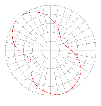 | ||||||||||||||||||
| Azimuth | Ratio | Azimuth | Ratio | Azimuth | Ratio | Azimuth | Ratio | ||||||||||||
| 0 | 0.707 | 10 | 0.594 | 20 | 0.497 | 30 | 0.410 | ||||||||||||
| 40 | 0.349 | 50 | 0.321 | 60 | 0.321 | 70 | 0.341 | ||||||||||||
| 80 | 0.375 | 90 | 0.453 | 100 | 0.558 | 110 | 0.660 | ||||||||||||
| 120 | 0.769 | 130 | 0.858 | 140 | 0.916 | 150 | 0.962 | ||||||||||||
| 160 | 1.000 | 170 | 1.000 | 180 | 0.962 | 190 | 0.916 | ||||||||||||
| 200 | 0.857 | 210 | 0.768 | 220 | 0.660 | 230 | 0.557 | ||||||||||||
| 240 | 0.497 | 250 | 0.497 | 260 | 0.594 | 270 | 0.707 | ||||||||||||
| 280 | 0.813 | 290 | 0.893 | 300 | 0.955 | 310 | 1.000 | ||||||||||||
| 320 | 1.000 | 330 | 0.960 | 340 | 0.898 | 350 | 0.813 | ||||||||||||
Structure Registration Number 1015278 Structure Type: TOWER Registered To: Saga Communications of Iowa, LLC Structure Address: .4 Mi W Of Us 69 .4 Mi S Of Ne 134th Ave Alleman, IA County Name: Polk County ASR Issued: 07/28/2010 Date Built: 07/23/2010 Site Elevation: 295.7 m (970 ft.) Structure Height: 396.9 m (1302 ft.) Height Overall: 397.9 m (1305 ft.) Overall Height AMSL: 693.6 m (2276 ft.) FAA Determination: 07/14/2003 FAA Study #: 2003-ACE-1361-OE Paint & Light FAA Chapters: A1, B, E, H Continue As Is OM&L = 24-HR HI-STROBES 41-48-01.0 N 93-36-28.0 W (NAD 83) 41-48-01.0 N 93-36-27.2 W (Converted to NAD 27) |
1541 East Grand Ave Des Moines, IA 50316 Phone: 515-287-0055 | Date: 08/21/2017 Application Certifier LATIN WORLD BROADCASTING, INC. 1541 East Grand Avenue Des Moines, IA 50316 Applicant CLARENCE M BEVERAGE Communications Technologies, Inc. Communications Technologies, Inc. P.o. Box 1130 Marlton, NJ 08053 BROADCAST ENGINEERING CONSULTANT ANTHONY T. LEPORE Radiotvlaw Associates, Llc 4101 Albemarle St Nw #324 Washington, DC 20016-2151 | |||||||||||||||||