
FCCInfo.com
A Service of Cavell, Mertz & Associates, Inc.
(855) FCC-INFO
|
|
WGRF from 09/20/1988 WGRF from 03/06/1986 |
|
|
|||||||||||||||||||
|
|
WGRF Channel: 245B 96.9 MHz Buffalo, New York Service: FM - A full-service FM station or application. Facility ID: 56102 Fac. Service: FM Analog & Digital Status: License Application Accepted: 05/23/1997 Application Granted: 10/30/1997 File Number: BLH-19970523KC License Expires: 00/00/0000 Prefix Type: This is a license for a commercial FM station Application Type: License To Cover FCC Website Links: LMS Facility Details This Application CDBS Application Other WGRF Applications Other WGRF Applications in CDBS Including Superseded Applications Mailing Address Correspondence for WGRF Correspondence related to application BLH-19970523KC Service Contour - Open Street Map or USGS Map (54 dBu) Service Contour - KML / Google Earth (54 dBu) Public Inspection Files History Cards for WGRF Facility Type: FM STATION Class: B, A Zone I or I-A station; with 25kW-50kW ERP and a class contour distance 39km-52km Site Location: 42-57-13.2 N 78-52-35.1 W (NAD 83) Site Location: 42-57-13.0 N 78-52-36.0 W (Converted to NAD 27) Effective Radiated Power: 24 kW Antenna Center HAAT: 217 m (712 ft.) Antenna Center AMSL: 398 m (1306 ft.) Antenna Center HAG: 213 m (699 ft.) Calculated Site Elevation: 185 m. (607 ft.) Height Overall*: 226 m (741 ft.) (* As Filed In This Application, may differ from ASR Data, Below.) Directional Antenna Antenna Make/Model: Oddball; usually designed by Applicant ODD891031IC Antenna ID: 14023 Polarization: | |||||||||||||||||||||
| Antenna Data for Antenna Id: 14023 WGRF FM File: BLH-19970523KC Oddball; usually designed by Applicant - ODD891031IC Service: FM | 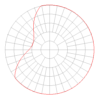 | |||||||||||||||||||||
| Azimuth | Ratio | Azimuth | Ratio | Azimuth | Ratio | Azimuth | Ratio | |||||||||||||||
| 0 | 1.000 | 10 | 1.000 | 20 | 1.000 | 30 | 1.000 | |||||||||||||||
| 40 | 1.000 | 50 | 1.000 | 60 | 1.000 | 70 | 1.000 | |||||||||||||||
| 80 | 1.000 | 90 | 1.000 | 100 | 1.000 | 110 | 1.000 | |||||||||||||||
| 120 | 1.000 | 130 | 1.000 | 140 | 1.000 | 150 | 1.000 | |||||||||||||||
| 160 | 1.000 | 170 | 1.000 | 180 | 1.000 | 190 | 1.000 | |||||||||||||||
| 200 | 1.000 | 210 | 1.000 | 220 | 1.000 | 230 | 1.000 | |||||||||||||||
| 240 | 0.866 | 250 | 0.708 | 260 | 0.562 | 270 | 0.460 | |||||||||||||||
| 280 | 0.410 | 285 | 0.402 | 290 | 0.398 | 295 | 0.402 | |||||||||||||||
| 300 | 0.410 | 310 | 0.460 | 315 | 0.501 | 320 | 0.562 | |||||||||||||||
| 330 | 0.708 | 340 | 0.866 | 350 | 1.000 | |||||||||||||||||
Structure Registration Number 1006688 Structure Type: 2TOWER Registered To: Nexstar Media Inc. Structure Address: 2077 Elmwood Ave Buffalo, NY County Name: Erie County ASR Issued: 05/28/2021 Date Built: 01/01/1948 Site Elevation: 184.9 m (607 ft.) Structure Height: 205.6 m (675 ft.) Height Overall: 226.2 m (742 ft.) Overall Height AMSL: 411.1 m (1349 ft.) Paint & Light FAA Chapters: 1, 3, 5, 14, 21 42-57-13.0 N 78-52-35.0 W (NAD 83) 42-57-12.8 N 78-52-35.9 W (Converted to NAD 27) |
780 Johnson Ferry Road Suite 500 Atlanta, GA 30342 Phone: 404-949-0700 Limited Liability Company | Date: 05/23/1997 Application Certifier MERCURY RADIO COMMUNICATIONS, LLC Buffalo Licenses, L.l.c. 350 Park Ave, 20th Floor New York, NY 10022 Applicant | ||||||||||||||||||||
|
| |||||||||||||||||||||