
FCCInfo.com
A Service of Cavell, Mertz & Associates, Inc.
(855) FCC-INFO
|
|
|
|  |
|
|||||||||||||||
|
|
KMSL Channel: 219C3 91.7 MHz Mansfield, Louisiana Service: FM - A full-service FM station or application. Facility ID: 121791 Fac. Service: FM Status: License Application Accepted: 02/23/2006 Application Granted: 03/06/2006 File Number: BLED-20060223AAI License Expires: 00/00/0000 Prefix Type: This is a license for a noncommercial educational FM station Application Type: License To Cover FCC Website Links: LMS Facility Details This Application CDBS Application Other KMSL Applications Other KMSL Applications in CDBS Including Superseded Applications Mailing Address Correspondence for KMSL Correspondence related to application BLED-20060223AAI Service Contour - Open Street Map or USGS Map (60 dBu) Service Contour - KML / Google Earth (60 dBu) Public Inspection Files Facility Type: NON-COMMERCIAL EDUC. FM Class: C3, A Zone II station; with 6kW-25kW ERP and a class contour distance 28km-39km Site Location: 32-10-39.6 N 93-55-02.7 W (NAD 83) Site Location: 32-10-39.0 N 93-55-02.0 W (Converted to NAD 27) Effective Radiated Power: 0 kW Horiz. ; 12 kW Vert. Transmitter Output Power: 1.302 kW Antenna Center HAAT: 0 m Horiz.; 103.4 m Vert. Antenna Center AMSL: 0 m Horiz.; 188.6 m Vert. Antenna Center HAG: 0 m Horiz.; 88.7 m Vert. Site Elevation: 99.9 m. (328 ft.) Height Overall*: 102.7 m (337 ft.) (* As Filed In This Application, may differ from ASR Data, Below.) Directional Antenna Antenna Make/Model: Shivley 6513-6-DA Antenna ID: 70536 Polarization: | ||||||||||||||||||
| Antenna Data for Antenna Id: 70536 KMSL FM File: BLED-20060223AAI Shivley - 6513-6-DA Service: FM | 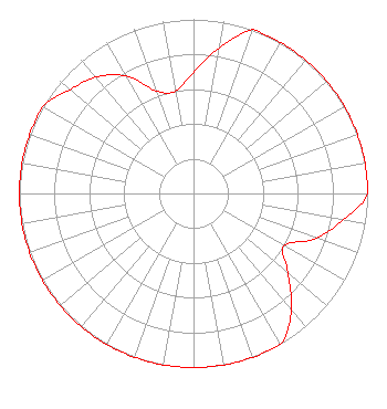 | ||||||||||||||||||
| Azimuth | Ratio | Azimuth | Ratio | Azimuth | Ratio | Azimuth | Ratio | ||||||||||||
| 0 | 0.697 | 10 | 0.847 | 20 | 1.000 | 30 | 1.000 | ||||||||||||
| 40 | 1.000 | 50 | 1.000 | 60 | 1.000 | 70 | 1.000 | ||||||||||||
| 80 | 1.000 | 90 | 1.000 | 100 | 0.875 | 110 | 0.750 | ||||||||||||
| 120 | 0.599 | 130 | 0.707 | 140 | 0.875 | 150 | 1.000 | ||||||||||||
| 160 | 1.000 | 170 | 1.000 | 180 | 1.000 | 190 | 1.000 | ||||||||||||
| 200 | 1.000 | 210 | 1.000 | 220 | 1.000 | 230 | 1.000 | ||||||||||||
| 240 | 1.000 | 250 | 1.000 | 260 | 1.000 | 270 | 1.000 | ||||||||||||
| 280 | 1.000 | 290 | 1.000 | 300 | 1.000 | 310 | 0.928 | ||||||||||||
| 320 | 0.873 | 330 | 0.778 | 340 | 0.628 | 350 | 0.597 | ||||||||||||
Structure Registration Number 1241989 Structure Type: TOWER Registered To: AMERICAN FAMILY ASSOCIATION Structure Address: End Of Fisher-davis Road Mansfield, LA County Name: De Soto Parish ASR Issued: 10/19/2009 Date Built: 01/24/2006 Site Elevation: 99.9 m (328 ft.) Structure Height: 102.7 m (337 ft.) Height Overall: 102.7 m (337 ft.) Overall Height AMSL: 202.6 m (665 ft.) FAA Determination: 12/22/2003 FAA Study #: 2003-ASW-5952-OE FAA Circular #: 70/7460-1K Paint & Light FAA Chapters: 4, 6, 12 32-10-40.0 N 93-55-03.0 W (NAD 83) 32-10-39.4 N 93-55-02.3 W (Converted to NAD 27) |
P.o. Drawer 2440 Tupelo, MS 38801-2440 Phone: 662-844-8888 Not-for-Profit | Date: 02/23/2006 Application Certifier AMERICAN FAMILY ASSOCIATION Great Lakes Broadcast Academy, Inc. P.o. Drawer 2440 Tupelo, MS 38801 Applicant MARSHA SHRADER American Family Association P.o. Drawer 2440 Tupelo, MS 38803 TECHNICAL CONSULTANT MARSHA SHRADER American Family Association | |||||||||||||||||